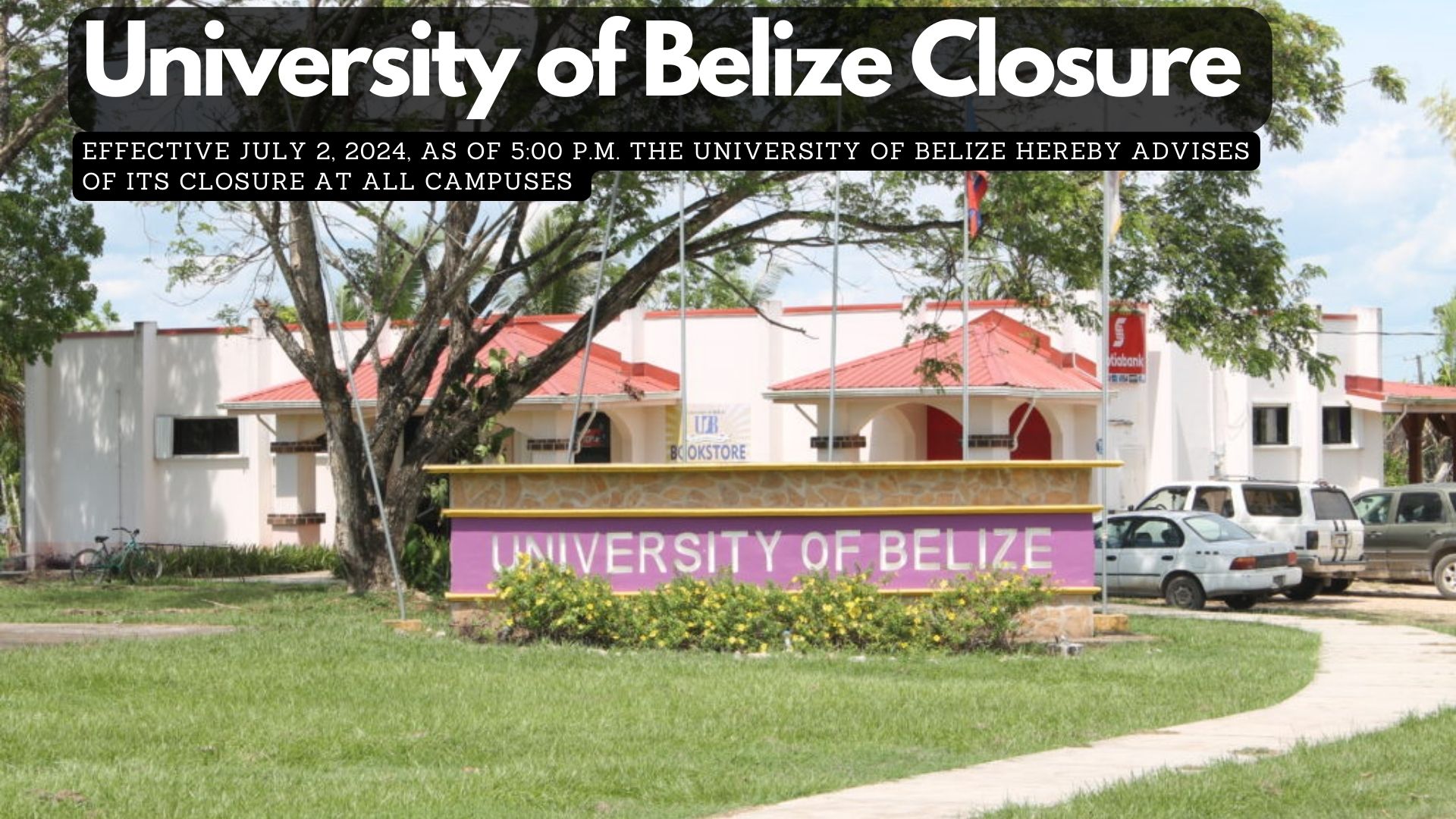
Effective July 2, 2024, as of 5:00 p.m. the University of Belize hereby advises of its closure at all campuses, due to the impending Hurricane Beryl. In this light, all summer classes will be canceled. Faculty members teaching summer classes are asked to upload all teaching materials to MOODLE. This preparation is in the event the University is unable to deliver face-to-face classes following the storm.
The University will keep you abreast of its reopening and asks everyone to keep safe and stay tuned to updates provided from official reports.
Minister of Home Affairs, Kareem Musa, confirmed with reporters today that a woman was “picked up” and detained by police over the weekend.
The video was recorded in 2021 in Gales Point Village, Stann Creek, by an adult female from Dangriga Town.
The child’s mother, who recently became aware of the video, reported the matter to the police.
Minister Musa said, “I asked the Commissioner about that when I was informed of the video and he had indicated I think it was Saturday or Sunday, right after the video was published, the individual in that video, the alleged individual, because no faces were shown in the video but the individual suspected to be in that video was picked up and detained by the police.”
The Office of the Prime Minister informs that the Prime Minister, Hon. John Briceño departed the country over the weekend en route to Panama City, Panama, to attend the Presidential Transfer of Command Ceremony of the Newly Elected, His Excellency Jose Raul Molino Quintero, on 1st July 2024.
The Prime Minister returns to Belize on Wednesday, 3rd July 2024, and during his absence, Hon. Cordel Hyde, Deputy Prime Minister and Minister of Natural Resources, Mining and Petroleum will hold over as Prime Minister.
Police Minister Kareem Musa told reporters this morning that it is an offence, “a criminal offence by virtue of the Cyber Crime Act of 2020,” to share and publish videos and photographs of a lewd and indecent nature. This warning comes after a surge of videos and photographs depicting lewd content began circulating widely on social media over the weekend.
Police Commissioner Chester Williams has also condemned the people sharing the videos. He shared, “It is an offence under the Cyber Act for one to use a computer devise to produce or distribute any video or photographs with the intent to humiliate, harm, or subject a person to public ridicule or embarrassment. Those who are therefore engaging in the posting, reposting, or further distribution of these videos or photographs are committing the crime of cyberbullying and can be prosecuted.”
Authorities urge individuals who have posted or shared such content to remove it immediately and cease further distribution. The law is clear on the matter, and violators could face significant penalties, including imprisonment.
In a statement addressing the situation, attorney Audrey Matura expressed dismay over the derogatory comments and memes following the release of explicit videos involving several women and a particular male. Matura emphasised the emotional distress caused to the individuals involved, particularly the female public figure featured in the videos. Matura encouraged the public to assist law enforcement by screen recording evidence of such posts, ensuring that perpetrators can be held accountable.
Thirty-seven-year-old Paul Arthurs of Ontario Village, Cayo District, was fatally stabbed on Saturday night in the New Site area of Blackman Eddy Village. Arthurs was involved in an altercation prior to his murder. Authurs sustained multiple injuries, including a severe stab wound to the abdomen. Arthurs was quickly transported to the Western Regional Hospital in Belmopan, where he was pronounced dead minutes later. Several individuals are in police custody.
Meanwhile, in Orange Walk, police are investigating the murder of sixty-year-old Norman Winston Gillett. Gillett was shot several times early on Sunday morning while he was on Monkey River Street in Orange Walk Town. Two other persons, including the deceased’s son and an acquaintance, were shot. Investigators believe that Gillett’s murder may be the result of an altercation that occurred earlier that night. We are told that a suspect has been identified.
The third murder reportedly occurred on Sunday night in Santa Elena Town, Cayo District. Anthony Smith was shot dead while he was in front of China Town Store. He was rushed to the hospital, where he later succumbed.
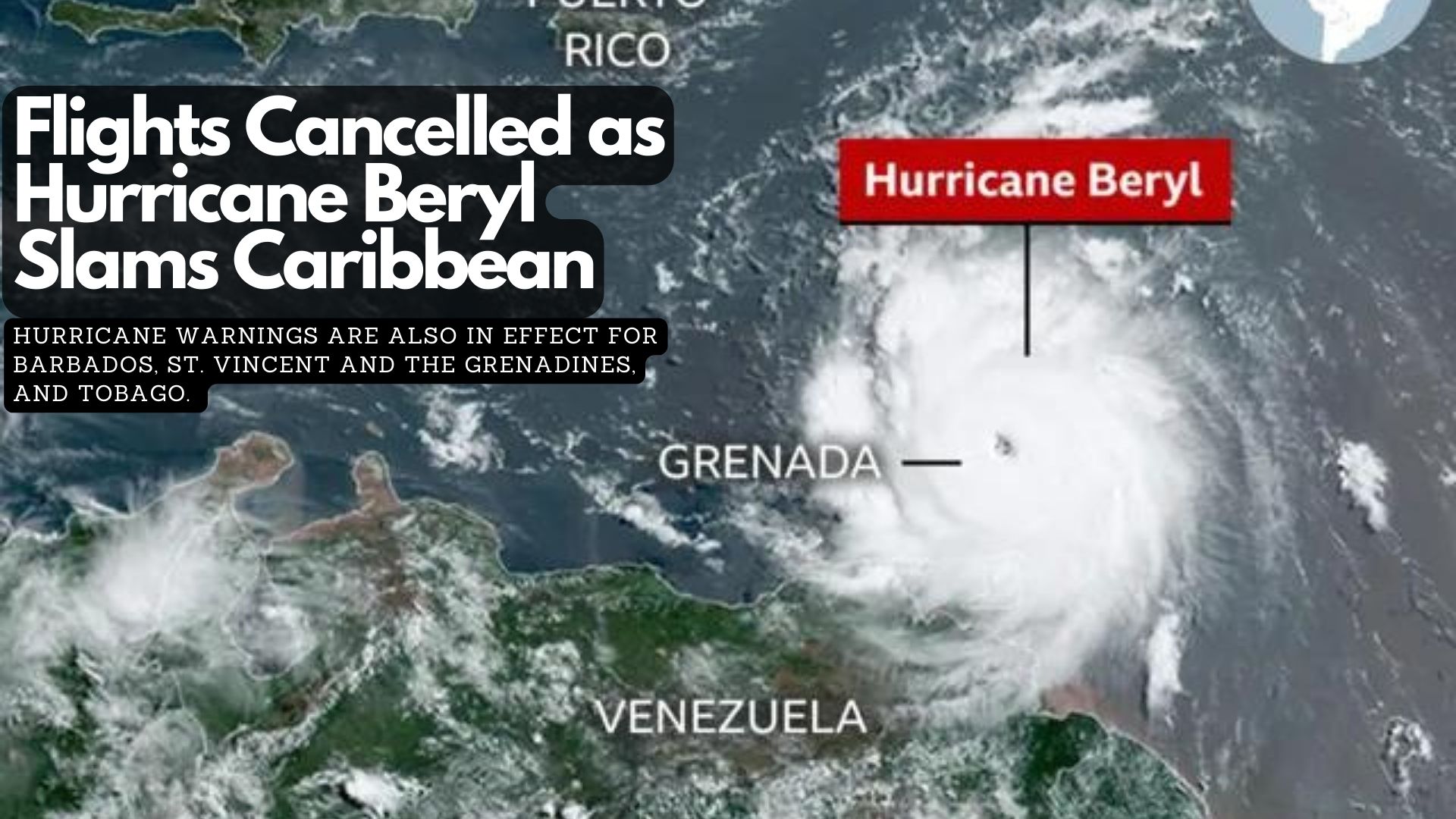
Hurricane Beryl has made landfall on Carriacou Island in Grenada. The hurricane, which has regained strength in recent hours, has prompted warnings of life-threatening winds and dangerous storm surges.
Hurricane warnings are also in effect for Barbados, St. Vincent and the Grenadines, and Tobago. Airports and businesses across the Caribbean have shut down, and residents have been urged to seek shelter as the potentially devastating storm hits the region. Dozens of flights were cancelled as Beryl approached on Sunday night, with leaders urging the public to heed warnings.
Beryl’s strength has been fluctuating. The hurricane was upgraded to a Category 4 on Monday after slightly weakening earlier.
Meteorologists say it is unusual for a hurricane of this strength to form this early in the year.
The US National Oceanic and Atmospheric Administration (NOAA) has warned that the North Atlantic could experience up to seven major hurricanes this year, up from the average of three in a season. It attributed record high sea surface temperatures as a contributing factor.
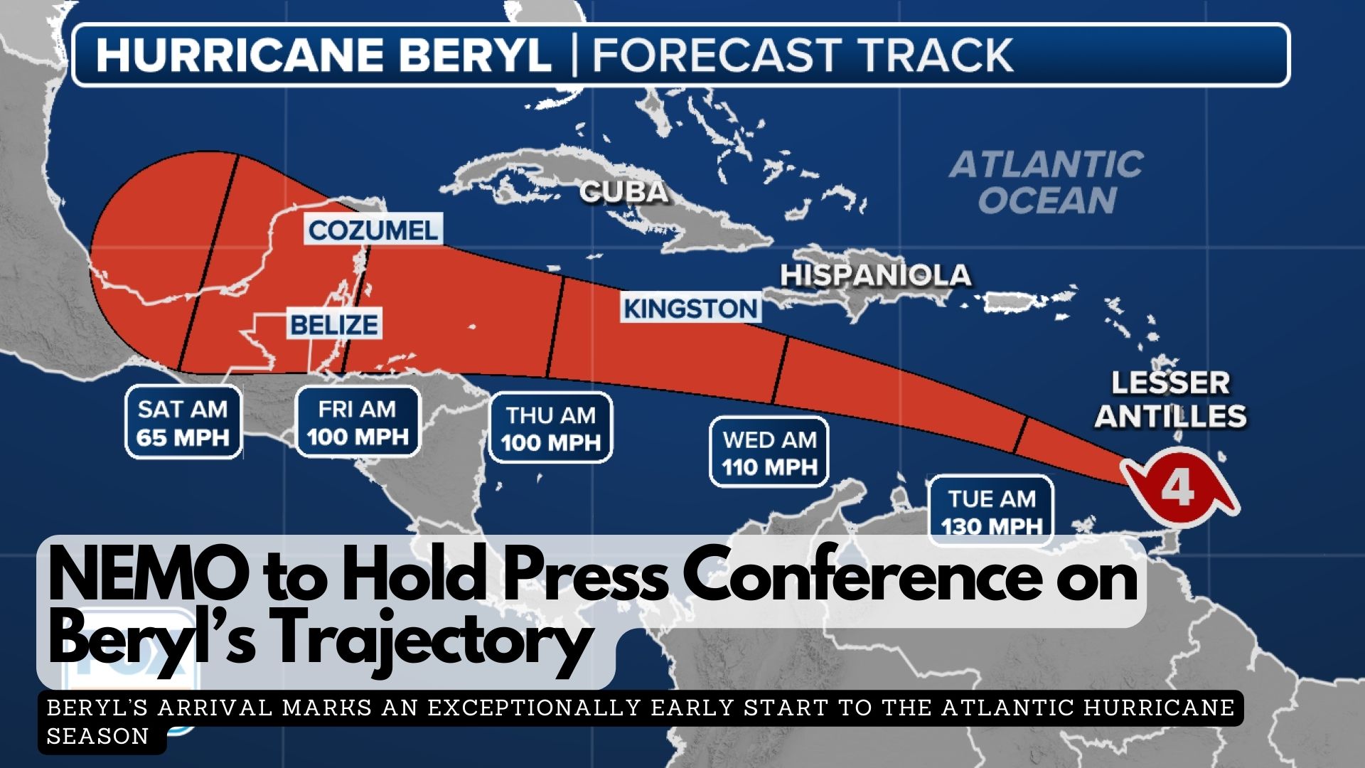
The Ministry of Blue Economy and Disaster Risk Management will hold a press conference today, July 1st, at 1:30 PM to provide an update on the trajectory of Hurricane Beryl in the Caribbean. The Belizean government is urging all citizens to continue their preparations without panic.
“Staying informed through official updates, having a plan, and remaining calm will help us all navigate any challenges that come our way.
Your safety is our top priority!”
Hurricane Beryl is lashing the Windward Islands as life-threatening Category 4 in a dangerous early start to the season.
Early Monday, Barbados, Grenada, and Trinidad and Tobago began feeling the impact of Hurricane Beryl. St. Vincent, the Grenadines, and Grenada are most at risk of being struck by the storm’s core. While a direct landfall with the eye passing over the coast may not occur, Beryl will still deliver a devastating blow to the nearby islands.
Beryl’s arrival marks an exceptionally early start to the Atlantic hurricane season. On Sunday, it became the earliest Category 4 hurricane on record in the Atlantic Ocean and the only Category 4 hurricane ever recorded in June. The bathtub-warm ocean waters that fueled Beryl’s rapid intensification are a clear sign that this hurricane season will be far from normal, influenced by a warming world due to fossil fuel pollution.
Beryl is breaking records for June because the ocean is currently as warm as it typically would be at the peak of hurricane season, said Jim Kossin, a hurricane expert and science advisor at the nonprofit First Street Foundation.
The National Hurricane Center is now tracking Hurricane Beryl, currently less than 1,000 miles east of the Caribbean.
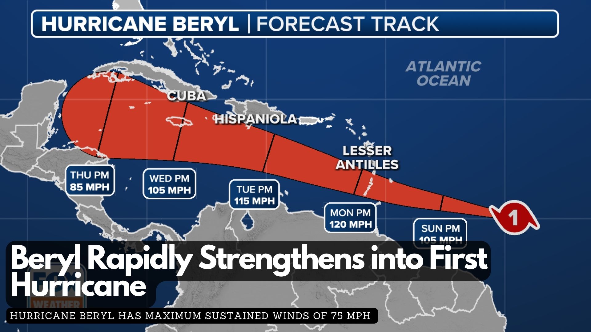
The second named storm of the 2024 Atlantic hurricane season rapidly intensified from a tropical depression to a tropical storm and then to a hurricane within 24 hours, aided by favorable atmospheric conditions.
According to the latest report from the National Hurricane Center, Hurricane Beryl has maximum sustained winds of 75 mph and a minimum central pressure below 992 MB, classifying it as a Category 1 hurricane on the Saffir-Simpson Hurricane Wind Scale. This early season hurricane formation is unusual, as the average date for the first hurricane in the Atlantic basin is August 11.
Water temperatures in parts of the central Atlantic are more typical of August and September, and Beryl’s small size has allowed it to avoid Saharan dust and adverse upper-level winds.
A Hurricane Warning is in effect for Barbados, while other nearby islands, including St. Lucia, Grenada, St. Vincent and the Grenadine Islands, Martinique, Dominica, and Tobago, are under watches.
Damaging winds, both tropical-storm-force and hurricane-force, extend up to 45 miles from the center. On its current trajectory, Beryl will impact the Windward Islands with damaging wind gusts over the next 72 hours as it moves west or west-northwest.
The latest forecast from the NHC indicates that winds could reach up to 120 mph in the eastern Caribbean, potentially upgrading Beryl to a major Category 3 hurricane. In addition to hurricane-force winds, the storm is expected to bring torrential rains, with forecast totals of 3-6 inches across Barbados and the affected Windward Islands, likely causing localised flooding.
The NHC has also upgraded its storm surge forecast, now predicting a “life-threatening” surge that could raise water levels by 5 to 7 feet above normal tide levels in areas of onshore flow.
As Barbados braces for severe weather in the next 48 hours, Prime Minister Mia Amor Mottley is urging Barbadians to stay prepared and vigilant as the country braces for Beryl’s impact.
In a video statement tonight, the Prime Minister mentioned meeting with various government departments and agencies earlier today to ensure readiness for any eventualities. She also encouraged Barbadians to look out for each other within their communities.
The Barbados Meteorological Services has issued a Hurricane Watch for Barbados, as Tropical Storm Beryl is anticipated to strengthen into a hurricane before reaching the island late Sunday night.
Residents should prepare for strong winds that could damage homes and properties, along with potential flash flooding, especially in flood-prone areas. Severe thunderstorms may also disrupt power and utility services.
Marine conditions are expected to worsen, with a small craft and high surf warning already in effect due to above-normal sea swells anticipated from Sunday night.
The public is advised to follow guidance from the Department of Emergency Management and local officials. Stay informed through the Barbados Meteorological Services, Department of Emergency Management, and Government Information Service websites, as well as their social media channels and local media.
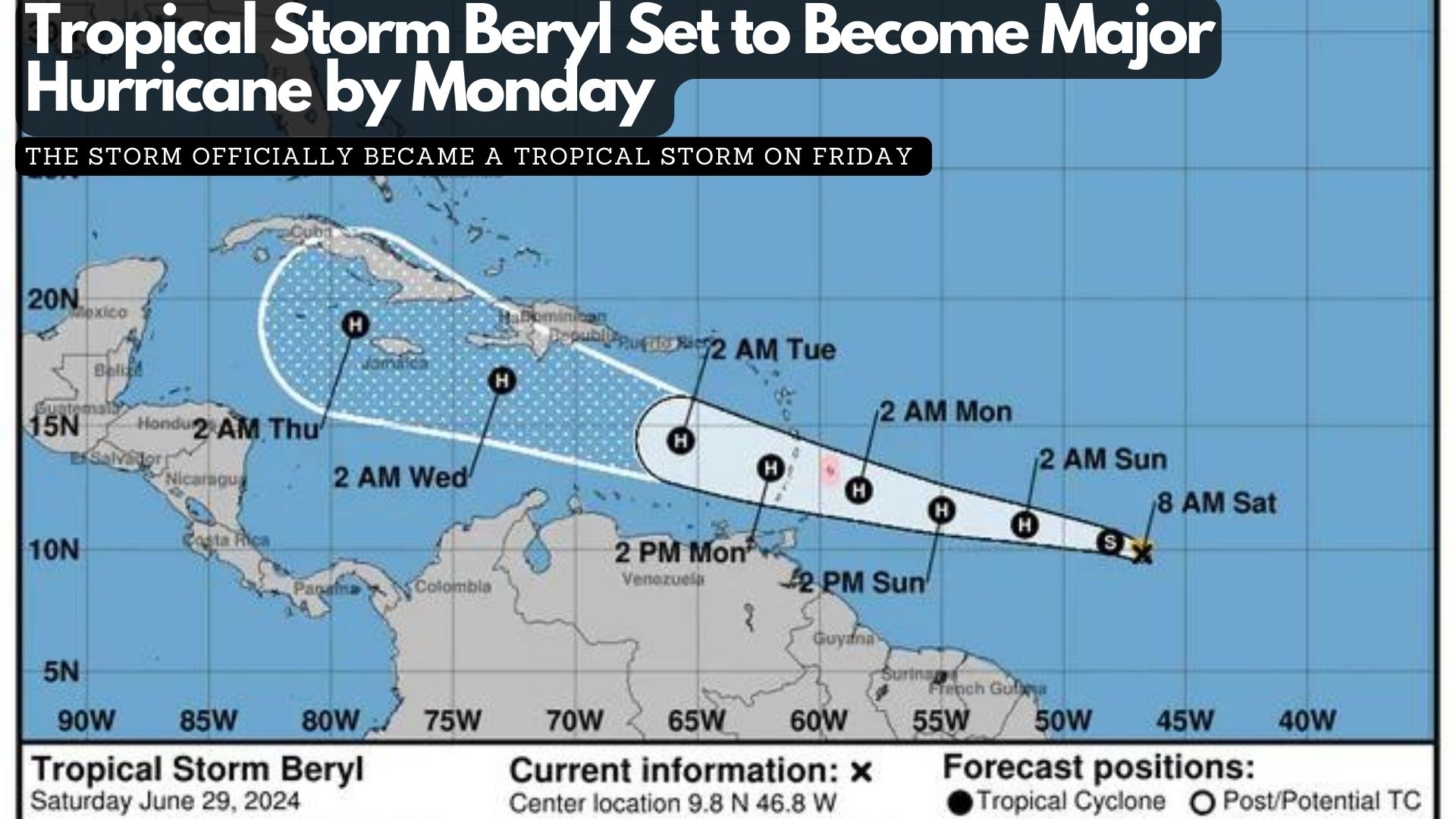
Tropical Storm Beryl formed Friday evening in the Atlantic, east of the Windward Islands, and is projected to become a “dangerous major” hurricane by Monday, according to the National Hurricane Center.
As the second named storm of the 2024 Atlantic hurricane season, Beryl is anticipated to reach hurricane status by Saturday night or Sunday morning as it moves westward. The storm officially became a tropical storm on Friday, approximately 1,100 miles southeast of the Windward Islands at the eastern end of the Caribbean.
As of the hurricane center’s 11 a.m. advisory on Saturday, Beryl was moving at about 23 mph, with maximum sustained winds of 65 mph. The center predicts that Beryl will strengthen into a hurricane by late Saturday or early Sunday and continue to intensify, reaching major hurricane status with winds of 111 mph or more before its center reaches the Windward Islands on Monday morning. The atmosphere and ocean conditions along Beryl’s path are described as “abnormally favorable for strengthening.”
However, conditions may become less favorable after the storm enters the Caribbean, where it could encounter disruptive winds that might prevent further strengthening, the center noted this morning.
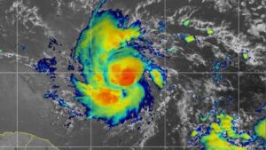
Tropical Storm Beryl on NOAA Satellite on Saturday morning.
Beryl is currently 820 miles east-southeast of Barbados, and tropical storm-force winds are expected to extend 45 miles outward from the center. The storm could bring heavy rain, hurricane-force winds, and dangerous storm surges and waves as it crosses the Windward Islands on Sunday night into Monday. A hurricane watch has been issued for Barbados, and more watches are expected later Saturday as the system moves further into the Lesser Antilles, which include the Windward Islands, Leeward Islands, and Leeward Antilles.
Barbados and nearby islands could receive 3 to 6 inches of rain, with localized flooding in vulnerable areas and life-threatening surf and rip currents. People in the central and western Caribbean should monitor the storm’s progress, keeping in mind that the forecast’s margin of error can be significant four or five days out.
By Sunday evening, as Beryl moves into the Caribbean Sea, it could have winds up to 105 mph. Although atmospheric conditions in June are typically not conducive to storm strengthening, some computer models are “quite aggressive” and suggest that Beryl could be a major hurricane before reaching the Windward Islands. Once the storm enters the Caribbean, forecast models are not yet in agreement on its potential path. For now, the official forecast cone shows that the hurricane’s center could be near or over the western half of the Dominican Republic and Haiti on Tuesday evening and over Jamaica or eastern Cuba on Wednesday evening.