As you just heard, forecasters are already sounding the alarm; it’s shaping up to be a busy hurricane season, with nineteen named storms on the radar. Experts at Colorado State University are predicting nine hurricanes, including four major ones. Now, there’s no way to know if any of those storms will head our way, but the City Emergency Management Organization isn’t taking any chances. They’re already out inspecting hurricane shelters across Belize City to make sure they’re ready, just in case.
Bernard Wagner, Mayor, Belize City
“WE have done a lot of training. They have been able to do what you call shelter inspection. They have worked very closely with NEMO. I can say outrightly that this is the best relationship we have had with NEMO as a group, because the structure, the organizational structure of NEMO has really been put in place by the new leadership. We feel that with the coordinated efforts of NEMO and CEMO in the city we want to be prepared.”
Reporter
“Where are we in terms of completion with these shelters and putting out the official list for shelters this year?”
Bernard Wagner
“Again that is coordinated with NEMO and NEMO identifies the shelters. We just go along with them in terms of knowing in what capacity they are you in, are they available, do they need repairs. If they need repairs we assist with that, but in terms of identifying and selecting shelters that is up to NEMO.”
As experts from across the region gather in Grenada for the Caribbean Climate Outlook Forum and a special media training on climate communication, the setting couldn’t be more symbolic. Grenada is still picking up the pieces after Hurricane Beryl tore through the island in July 2024, leaving a trail of destruction in its wake. Now, with the 2025 hurricane season fast approaching, the big question is: is Grenada ready? News Five’s Benita Keme Palacio sat down with Prime Minister Dickon Mitchell to talk about the country’s recovery efforts and how it’s preparing for what could be another active season.
Dickon Mitchell
Dickon Mitchell, Prime Minister, Grenada
“We have I would say, done a better job, we had a pretty devastating hurricane in 2004. We learned a lot of lessons since then, and so I think we were far better prepared to handle Hurricane Beryl, thankfully. It was mostly the northern part of Grenada and Carriacou and Petite Martinique. But, having said that, I think there are a number of things that we have become better at; financial resilience is one of those. We’ve been able to, over the years, pay for parametric insurance, which allows us to mitigate a lot of the financial losses that we have suffered as a result of Hurricane Beryl. We also purchased insurance for our farmers, so we’ve been able to help them, including some of our fishermen. In that regard, we’ve done well. We also have built into our debt instruments hurricane suspension clauses, which allow us to suspend debt payments to our creditors in the event they need the cash flow to finance the recovery and the rebuilding in the aftermath of natural disasters. In that sense, we have institutionalized financial resilience to address the loss, damage, and consequences of climatic events. Behavior-wise, I think there’s a lot of work to be done, and from an energy perspective, we are still not where we need to be in terms of having more renewable and non-carbon-type energy into the mix.”
The scars of Hurricane Beryl still linger within the country, but PM Mitchell says the country is better positioned to face what’s ahead. The Caribbean Climate Outlook Forum (CariCOF) officially opens tomorrow, and as we mention we have a team in Grenada and we’ll have more on the forum on Thursday’s newscast.
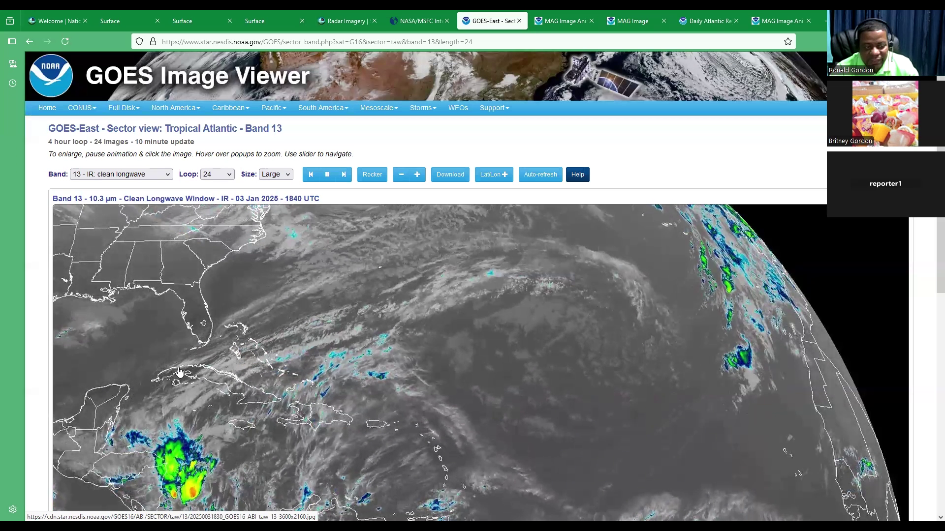
2025 started off with a bang—or rather, a splash! For Belizeans in the northeastern parts of the country, New Year’s Day was all about rain instead of fireworks, with rainfall totals reaching between five and seven inches. Chief Meteorologist Ronald Gordon explained that these showers are due to a lingering front over the region. When we asked Gordon about the upcoming weekend weather, he told us to expect more rain and cooler temperatures.
Voice of: Ronald Gordon
Voice of: Ronald Gordon, Chief Meteorologist
“We have a front which has been lingering just north of the country. this front is very weak and diffused. And at the moment, extending across the Bahamas, Cuba, into the northwestern Caribbean Sea, up to northern Belize at the moment. Previously it was located over just the north of Yucatan and ahead of the front we have had a lot of prefrontal activity as we refer to it, and that is rainfall. This front is drifting very slowly to the south and will basically dissipate over the country over the weekend. However, it’ll continue, continue to produce some rainfall, which you will share now based on the forecast. So, I’m advancing the forecast frame up to this point, which shows the line of rain associated with the front, extending to Belize. And as we move into the weekend, farther, you will see that most of the activity will drift more to the south of the country. And that will persist throughout Saturday into Sunday, with most of the rainfall being recorded over the southern districts of Toledo and Stann Creek. However, we do expect that we still could expect some light rains over the other parts of the country, but not significant accumulations with this particular front as it dissipates. By Sunday, we should see better conditions as the front disappears even farther. And then what you’re seeing here coming across the United States is another significant cold front. Extending into the northwestern Gulf of Mexico. As I advance the frame up to Monday, you can see the front. Now, this new front extends across the central Gulf of Mexico into the Bay of Campeche and later Monday night into Tuesday, you begin to see these greens again over Belize, And this is associated with prefrontal activity from this next front, which is approaching around the middle. Or the early to the middle part of next week.”
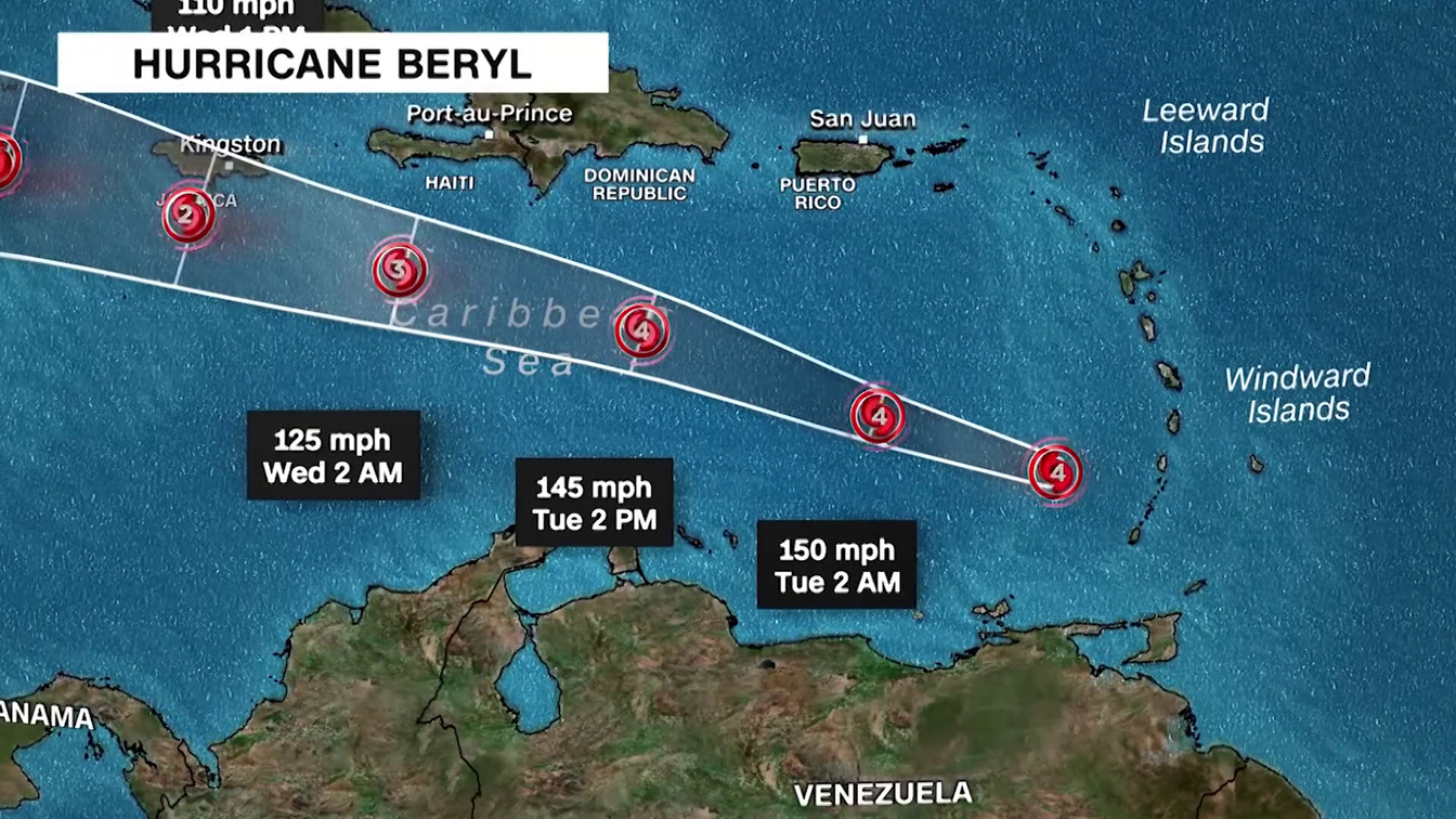
The 2024 Atlantic hurricane season officially concluded on November 30, surpassing historical averages in activity. This season recorded 18 named tropical systems, significantly higher than the annual average of 14. Of these, seven were tropical storms, and 11 developed into hurricanes, with a surge in activity after the typically peak month of September.
Belize was impacted by two tropical storms, Nadine and Sara.
The hurricanes this season were categorised as follows:
Category 5: Beryl and Milton
Category 4: Helene
Category 3: Kirk and Rafael
Categories 1 & 2: Debby, Ernesto, Francine, Isaac, Leslie, and Oscar
Meanwhile, tropical storms such as Alberto, Chris, Gordon, Joyce, Nadine, Paty, and Sara remained below hurricane strength.
Residents in various regions are advised to monitor waterways and exercise caution due to fluctuating water levels.
In Region 7, the Rio Hondo at Blue Creek North, Santa Cruz, San Antonio, San Roman, and Douglas to the coast is experiencing decreasing flood stage levels. Meanwhile, the New River at Hill Bank, Tower Hill, and Caledonia to the coast is at bankfull stage levels.
In Region 9, extreme caution is urged as the Mopan River at Benque Viejo Town shows receding flood levels nearing Hurricane Mitch levels, with further decreases expected. The Macal River at Fortis facilities, including the Chalillo, Mollejon, and Vaca spillways, is actively spilling. At San Ignacio, flood levels are decreasing, while on the Belize River at More Tomorrow, flood levels are also dropping. However, at Double Run, increasing flood stage levels persist. In Crooked Tree Lagoon, water levels have surpassed the causeway and continue to rise.
In Region 11, decreasing flood stage levels are reported on the Sibun River at Freetown Sibun and the Southern Lagoon at Gales Point Village. Watersheds along the eastern slopes of the Maya Mountains and the Sittee River at Kendal Bridge are experiencing minimal decreases in flood levels. However, the branches of the Monkey River at Swasey and Bladen, the Deep River at Medina Bank, and the Rio Grande at San Pedro Columbia and Big Falls South are showing above-normal levels. The Moho River at Blue Creek South and Jordan and the Temash River at Crique Sarco are also reporting above-normal levels.
In Region 13, the Sarstoon River continues to exhibit above-normal levels.
Further updates will be provided as necessary. Residents are encouraged to remain vigilant and take all necessary precautions.
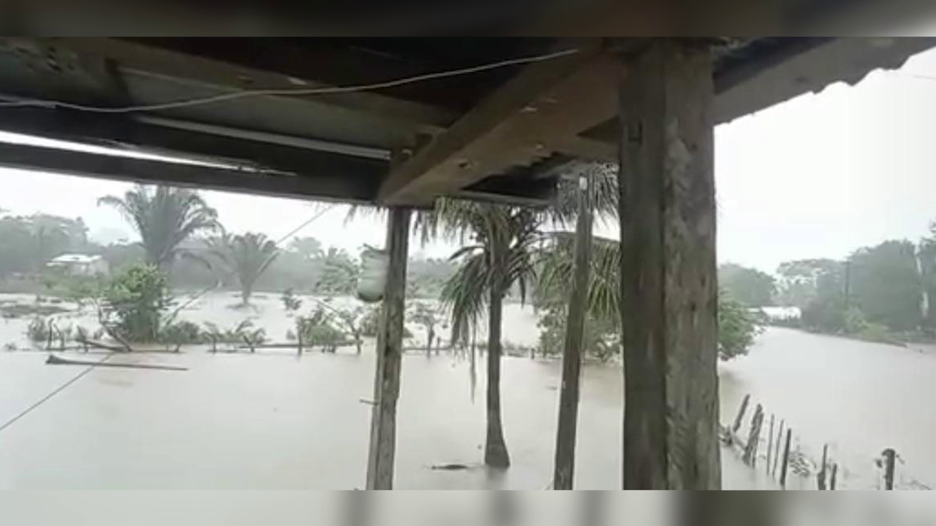
We’ve already shared how the villagers in Roaring Creek are coping with the floodwaters from Tropical Storm Sara. Meanwhile, residents on the other side of the creek in More Tomorrow Village are doing slightly better. Over the weekend, they were wading through waist-deep water, but it has since receded. However, one villager mentioned that they expect the water levels to rise again in the coming days.
Terrence Sutherland
Terrence Sutherland, More Tomorrow Resident
“The rain that come the last couple of days mein. It really flood out this area from here gaan right down tha lone water you see and I went to the village this morning and mein it was so rough and I know the people down there tek a liking because of the rain, it was a lot of rain. Down that side it was pretty rough. Like I tell you in some of the house people still have water and some have more water like what I tell you the river is still coming down, so the river nuh reach yet down here.”
Britney Gordon
“How high would you say the water is”
Terrence Sutherland
“Well I would figure about 3 or 4 feet in those people house, and it will get more higher because like I tell you the water still the come down.”
Britney Gordon
“And you said it wasn’t too bad on your farm over here, but like what did you see?”
Terrence Sutherland
“Well when I come out from out of my house. I come out like two and a half feet out in my yard with water.”
Britney Gordon
“And you said you recently to more of the entrance, what was it like when you were living back there?”
Terrence Sutherland
“It was pretty rougher, just like what I tell you. The water reach way in the house. Like when I mih deh deh like a couple of five inches inside the house.”
Britney Gordon
“Would you say that it has gotten worse over the years? Or has it been better? Is there anything to alleviate it?”
Terrence Sutherland
“Well I think with this flood weh the come right now it’s just like a hurricane flood. To me it get the same way or worse. It could be a little worse”
Britney Gordon
“How do you see the villagers coping with it.”
Terrence Sutherland
“Well. Like I tell you I mih live back there already more in the village before I move to my farm and we just have to cope with it. Like an animal on a little hill you know but all ah we just have to stay together.”
Britney Gordon
“So they just go through the water and go where they have to go?”
Terrence Sutherland
“Yeah, they have to come out and do a little shopping, and go back inside and just try to make life back again, but yesterday the little group mih come back here and pass and I think they gave them a little food. The food they gave them is not for no long while but for probably a couple days, about two three days and they wah need food again.”
Britney Gordon
“So how long do you think it will be until this water goes down, you said more is to come but how long does that usually last?”
Terrence Sutherland
“When that water left from San Ignacio, it take like two days and a half to reach down here and down here it will last another two and a half to three days down right in the village.”
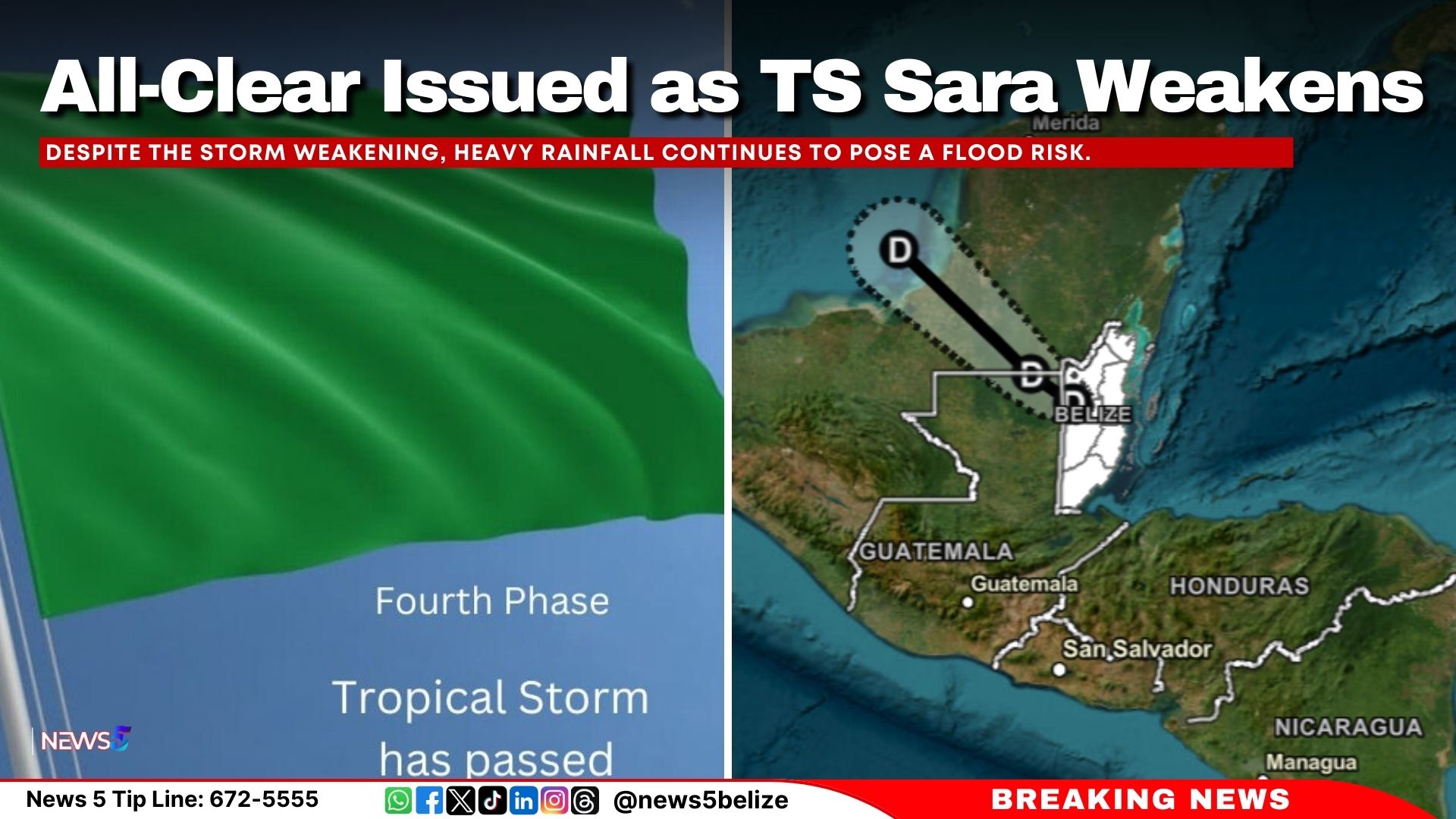
As of 12:00 PM on Sunday, November 17, 2024, Tropical Storm Sara has weakened into a tropical depression. The storm, now located about 55 miles west of Belize City, is moving west-northwest at 8 mph with maximum sustained winds of 35 mph. The tropical storm warning for Belize has been discontinued, and an All-Clear has been declared.
Despite the storm weakening, heavy rainfall continues to pose a flood risk. According to the National Emergency Management Organisation’s (NEMO) latest advisory, Belize has already recorded up to 18 inches of rain in some areas, with another 1-2 inches expected by evening. Flood warnings remain in effect, particularly for low-lying areas, and significant flooding is possible, especially in Cayo and Belize Districts.
Local roads are affected by flooding, with some routes only passable by large vehicles. Several bridges, including the Salvador Fernandez Bridge in Bullet Tree, are closed due to rising water. The Transport Department will provide an update on bus services later today.
The National Emergency Management Organization (NEMO) advises continued caution, particularly in flood-prone areas. Shelters remain open, and residents are urged to monitor conditions and follow emergency plans. The Philip Goldson International Airport is expected to resume operations on Monday, November 18.
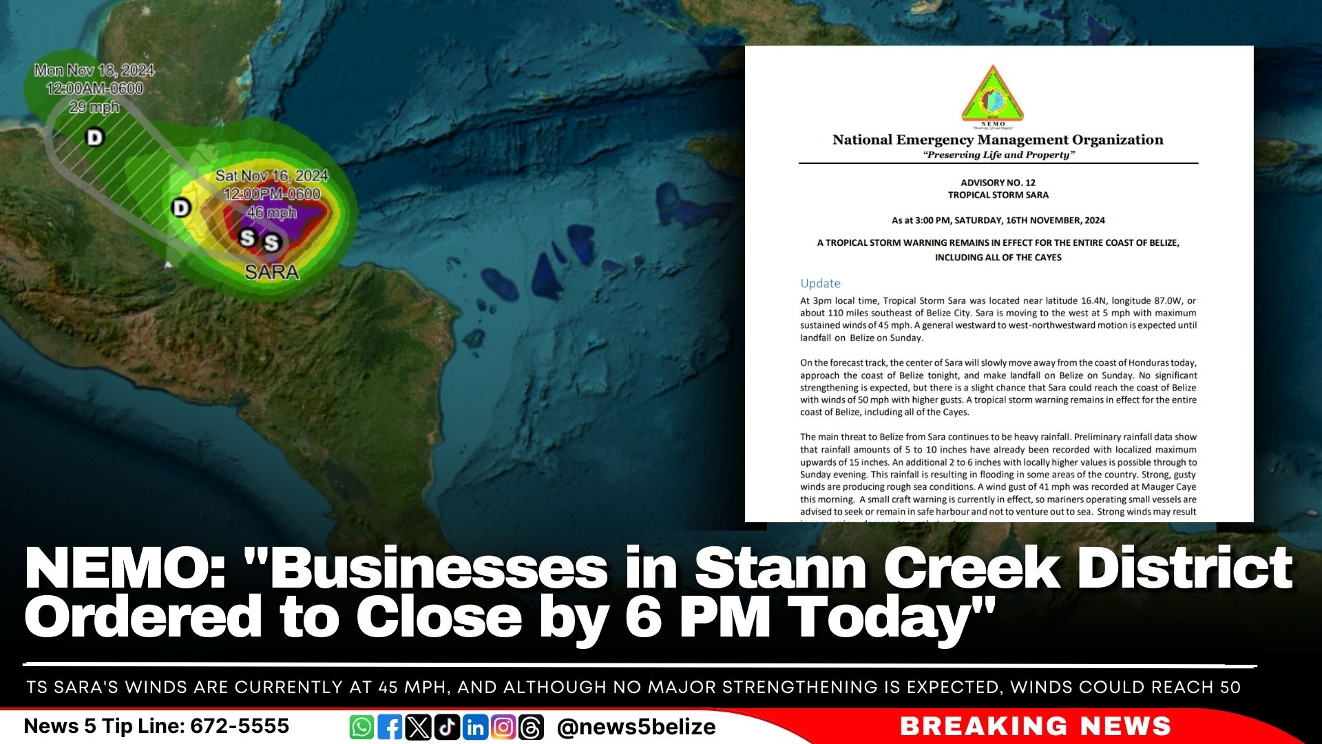
Tropical Storm Sara continues moving closer to Belize, with the latest update at 3:00 PM showing the storm just 110 miles southeast of Belize City. NEMO reinforces its tropical storm warning for the entire Belize coastline, including the cayes. Businesses in the Stann Creek District are ordered to close by 6 PM today, and all sectors—agriculture, tourism, and fisheries—are urged to implement their emergency plans. “Businesses in the Stann Creek District are to close at 6 p.m. today and remain closed until the ALL CLEAR is issued,” the advisory notes.
“The main threat to Belize from Sara continues to be heavy rainfall,” NEMO warned, with some areas already seeing up to 15 inches of rain. An additional 2 to 6 inches is expected through Sunday evening, which could cause severe flooding, especially in the Rio Hondo, Macal, Mopan, and Belize Rivers. A small craft warning continues to be in effect due to rough seas.
TS Sara’s winds are currently at 45 mph, and although no major strengthening is expected, winds could reach 50 mph as the storm nears. NEMO has activated Phase 3—Red Two—of the National Hurricane Plan, meaning landfall is expected within 36 hours.
“Persons living in areas under Flood Warning MUST remain vigilant and be prepared to implement emergency plans if necessary,” NEMO advised. Shelters will open if needed, and the public will be updated through district coordinators.
The Philip Goldson International Airport ceased operations at 3:15 PM today, and bus services are running based on road conditions.
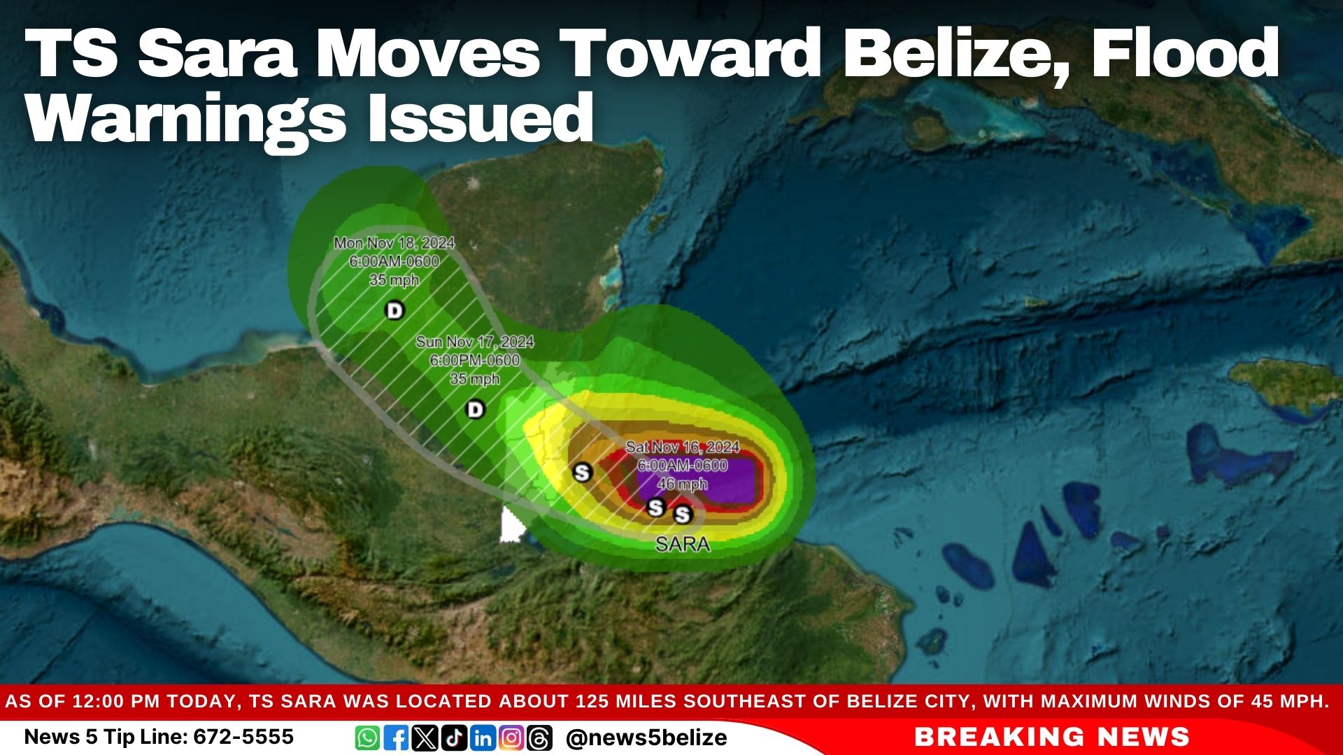
Belize remains on high alert as Tropical Storm Sara continues to move toward the country. The National Emergency Management Organization (NEMO) said in its latest advisory that the nation remains in Phase 3—Red Two of the National Hurricane Plan, signalling that landfall is expected within the next 36 hours.
As of 12:00 PM today, Tropical Storm Sara was located about 125 miles southeast of Belize City, with maximum winds of 45 mph. NEMO reports that the storm is expected to approach the coast tonight and could make landfall by Sunday.
The biggest concern with Tropical Storm Sara is heavy rainfall. Since Thursday, some areas have already received over 15 inches of rain, and many other areas have seen 4 to 8 inches. NEMO warns that an additional 3 to 8 inches of rain could cause “significant and life-threatening flooding.”
The Central and Northern parts of Belize, including the Rio Hondo, Macal, Mopan, and Belize Rivers, are under Flood Warnings.
NEMO is advising all Belizeans, especially those in flood-prone areas, to start their emergency plans now. Residents should “remain vigilant” and be ready to shelter in place or evacuate if necessary. The agricultural and tourism industries are also being warned to take precautions, as strong winds and flooding could affect them.
Authorities urge the public to stay informed through official channels and to call NEMO’s hotline at 936 for help.
The National Meteorological Service (NMS) has issued weather alerts due to Tropical Storm Sarah, which is expected to make landfall on Sunday. In a briefing this morning, Chief Meteorologist Ronald Gordon explained that the storm is located about 140 miles southeast of Belize City, moving west-northwest at a slow pace with maximum winds of 45 miles per hour.
A Tropical Storm Warning is now in effect for the entire Belize coastline and offshore areas. A Small Craft Warning has also been issued since yesterday and remains in effect, advising boat operators to stay in safe harbor. The weather will remain stormy today and tomorrow, with “squally and gusty winds and continued rainfall,” Gordon said.
Heavy rainfall has already been reported across the country, with one station recording over 15 inches of rain. Some areas have seen almost 4 inches in the past 12–18 hours.
“We expect conditions to remain cloudy tomorrow with showers persisting and decreasing later in the afternoon, afternoon into the night. By Monday, we expect fair conditions,” Gordon said, adding that the weather should improve just in time for the 19th of November celebrations.
Gordon said that the storm’s disorganised structure suggests that most of the heavy weather is occurring well ahead of its center. “A lot of the activity is occurring away from the centre,” he explained. This means that once the storm makes landfall tomorrow, conditions may improve quickly.