Heavy rains over the weekend have caused significant disruptions in Belize, affecting various regions. On Sunday, the National Emergency Management Organization (NEMO) reported that several roads in the rural Orange Walk District were impassable due to ongoing flooding, including the J&W road in Belmopan.
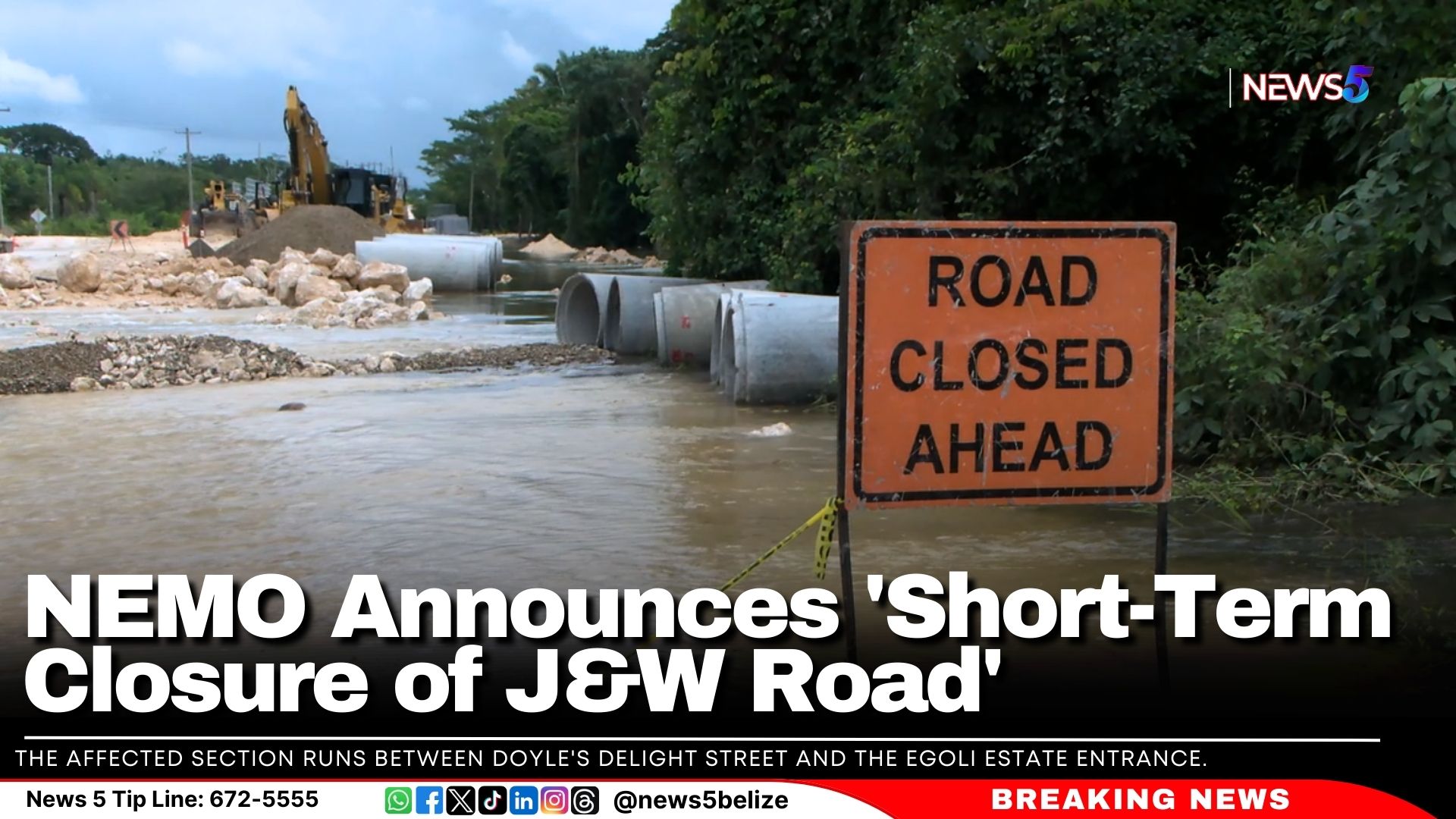
Today, the Ministry of Infrastructure Development and Housing and NEMO announced a short-term closure of the J&W Road due to rising waters. The affected section runs between Doyle’s Delight Street and the Egoli Estate entrance. The road is expected to remain closed for the rest of today, October 28, and most of Tuesday, October 29. The closure may extend if conditions do not improve.
The ministry advised all motorists to take the Cemetery Road route to John Saldivar Boulevard during this time.
A severe flood warning is in effect for the Río Hondo at Blue Creek North and Freetown Sibun on the Sibun River. Floodwaters are expected to rise, and an Excessive Rainfall Watch has been issued for the next 12-24 hours nationwide. Urban flooding is anticipated in vulnerable areas.
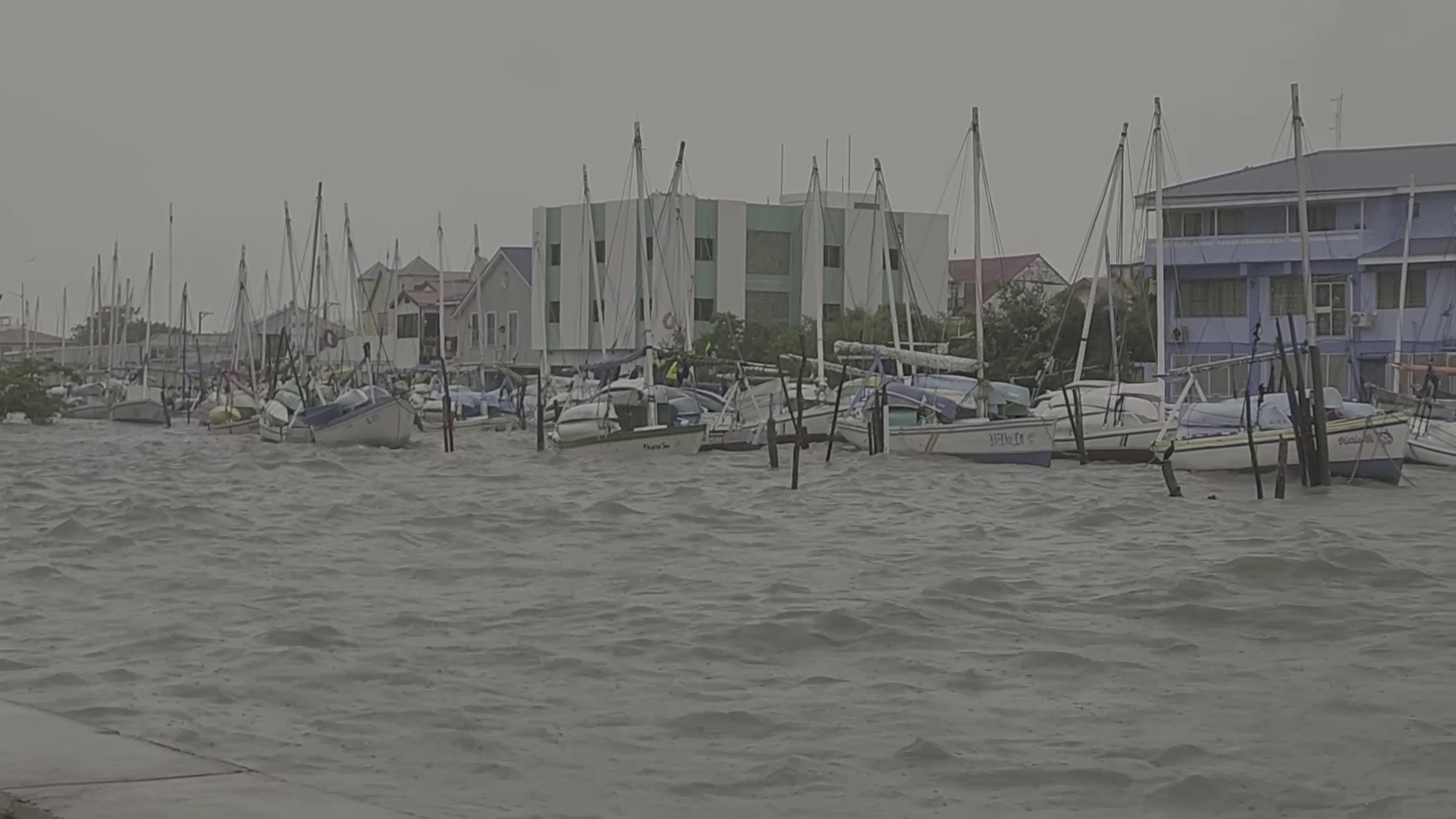
Tropical Storm Nadine swept through southern Belize City on Saturday, bringing powerful winds and heavy rain that tested the city’s resilience. Despite the storm’s intensity, the old capital has shown a remarkable recovery. Mayor Bernard Wagner shared insights on how the storm impacted the city and praised the community’s swift response and resilience.
Bernard Wagner, Mayor of Belize City
“No, it was to the best of my knowledge and the reports that I receive is that we just had the flooding in the streets. Some of the flood prone areas that are usually flooded, got extensively flooded, but with the king tides coming in and climate change and all of these converging it’s important that we put in place actions such as this climate action doing our part in reducing greenhouse gases. If we don’t do our part you’ll continue to see stronger storms more adverse climate conditions in our country.”
Tropical Storm Nadine roared to life overnight, transforming into a formidable force by Saturday morning. By 10 a.m., it slammed into Belize just south of the city. Winds clocked in at a blistering 50 miles per hour. Heavy downpours were most evident on Ambergris Caye, Caye Caulker and in the Corozal District. In Belize City, despite heavy rains, several streetside vendors were operational. Meanwhile, over in the west, the storm left its imprint in different ways. News Five’s Paul Lopez reports.
Paul Lopez, Reporting
Amidst the pounding winds and torrential downpour of Tropical Storm Nadine, it was business as usual in Belize City. Streetside vendors were out selling their products.
Street Side Vendor #1
Street Side Vendor #1
“I decided to come out because money need fih mek and if I don’t come out no money nuh mek. So, I need fih the out yah to make sure I create this service fih customers weh need it most. Reasonable stuff check.”
Street Side Vendor #2
Street Side Vendor #2
“I got people, customers weh notice I come out. But I bring out only hald of what I usually bring out. This is the last amount weh lef out ah the half. I didn’t evenbring out pork. This is the last amount left out of that half.”
Despite Tropical Storm Nadine making landfall, the Belize City market next to the bus terminal remained bustling on Saturday. Vendors carried on with business, even as NEMO strongly advised halting all operations due to the storm.
Daniel Mendez
Daniel Mendez, National Emergency Coordinator, NEMO
“Our messaging had been clear in regards to taking this seriously. We strongly recommended that businesses closed. We cannot take it for granted that this is a small storm. We don’t know what the impact will be.”
According to the National Hydrological Service of Belize, the Macal River, out west, rose approximately fifteen feet above normal levels, while the Mopan River continues to rise tonight.
Tennielle Hendy
Tenielle Hendy, Chief Hydrologist, NHS
“Recalling from memory, I believe the Macal has reached about fifteen feet, five point one two meters, which is about fifteen feet from normal flow. For Mopan right now, it is about six to ten feet above what is normal. But this system is still rising. So, that is still not the peak of this flood event we are going through.”
The Macal River runs through the Twin Towns of San Ignacio and Santa Elena. The low-lying bridge that connects the two communities became impassable on Saturday afternoon. By Sunday morning, floodwaters had started to recede. Mayor Earl Trapp of the Twin Towns spoke to News Five about a riverbank project along the Macal River that had been inaugurated just eight days prior, only to be swept away by the floods. Trapp clarified that he had no involvement in the project.
Earl Trapp
Earl Trapp, Mayor, SI/SE
“All of a sudden, the minister and area representatives came up with this of which I was not a planned. I am for the sidewalk and for the stage. I am not for the beach, because one little terential rain and it washes away.”
Paul Lopez
“So now the beach has washed away.”
Earl Trapp
“Yes, it was right in front of that stage. That is gone. So, now it means if you have a flood every month every month you will have to put back sand. I think we can do better if we can analyze the situation properly and yes with residents, I think we could make better informed decisions.”
Flood waters also destroyed a pedestrian bridge in San Ignacio. The low-lying bridge that connects the Twin Towns remains impassable. The Iguana Creek Bridge was also flooded, and that remains impassable tonight. One resident in that area visited the bridge on Sunday morning to assess the flood waters. She owns a farm near the river. Her farm was devastated by flood waters in 2020.
Denise Gordon
Denise Gordon, Resident, Blackman Eddy
“For now it doesn’t look really bad when compared to other years. So, for now to me it looks ok and it seems like it is going down fast.”
So, what’s the flood forecast for the next few days? The National Hydrological Service is reporting Hurricane Keith-level flooding along the Mopan River and Hurricane Mitch-level flooding along the Rio Hondo River. Flood alerts have also been issued for river systems in southern Belize. Chief Hydrologist shared more.
Tennielle Hendy, Chief Hydrologist, NHS
“The areas of concern that are flooding at the moment. We have a flood alert, which means that flooding is possible. So, you should be prepared. It is for the watersheds off the eastern slopes of the Maya Mountains. I know you would say that sound like where is that. We are looking at all these rivers, south Stann Creek, north Stann Cree, Sittee River, Bladden, Swasey, Deep River, all these rivers coming off the eastern slopes of the Maya Mountains. We have a flood warning in effect for Rio Hondo, New River and the tributaries to Rio Hondo, the Boots River, Rio Bravo. In the central area in Belmopan we have for the Mopan, Macal and Belize River. To the bottom of the central we have for the Sibun River. The San Ignacio and Iguana Creek low lying bridges are still impassable and we have specifically for the Rio Hondo, severe flood warning. This is because we have been monitoring the levels at our station at Blue Creek. That has exceeded Hurricane Mitch levels. Those are mainly the area we are lucking at. More so the Mopan and the Rio Hondo, we need to be vigilant. You were asking about other rainfall activities. Recall before Nadine developed we were receiving some rainfall. It is in this same western central region that we were getting these rainfall volumes then came tropical storm Nadine and even that Nadine is no longer over us, it is in Guatemala and still raining, we are receiving the rainfall and runoff values through the riverine systems. That is the contributing factor as to why we are seeing levels approaching levels of these historical systems like Hurricane Keith for the Mopan and Rio Hondo for Hurricane Mitch.”
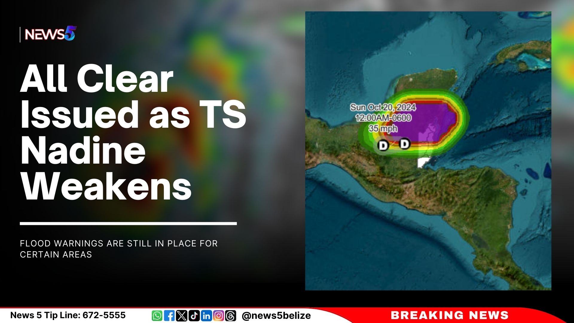
As of 6:00 PM on Saturday, October 19, 2024, Tropical Storm Nadine has weakened to a tropical depression, prompting the discontinuation of all coastal warnings. At 6:00 PM, Nadine was located near latitude 17.3N, longitude 90.0W, about 120 miles west of Belize City, with maximum sustained winds of 35 mph. The storm is moving westward at 13 mph and is expected to continue weakening as it moves further inland and away from Belize.
On the advice of the Chief Meteorologist and the National Emergency Management Coordinator, Prime Minister John Briceno has issued the “All Clear” for the entire country, signaling that Belize is no longer under threat from tropical storm conditions. However, residents are advised to remain cautious as additional rainfall of 1 to 2 inches is expected overnight, accompanied by gusty winds. A small craft caution remains in effect, and operators are urged to exercise care.
Flood warnings are still in place for certain areas, particularly the Iguana Creek low-lying bridge and the Coastal Highway from La Democracia to Hope Creek junction, which may become impassable. Rivers, including the Rio Hondo, New River, Booth’s River, Rio Bravo, Mopan, Macal, and Belize Rivers, along with those originating from the eastern slopes of the Maya Mountains, remain at risk of flooding. There is also a risk of landslides in the northern and central highland regions. The San Ignacio Low Lying Bridge remains closed, and the Mollejon Spillway is active.
The National Emergency Management Organization (NEMO) and the Ministry of Health and Wellness are urging the public to avoid contact with floodwaters, which can pose significant health risks, including infectious diseases, chemical hazards, and injuries. Exposure to contaminated water may lead to illnesses such as skin infections, stomach illness, and waterborne diseases like typhoid fever, cholera, leptospirosis, and hepatitis A.
Despite the “All Clear,” residents are encouraged to stay alert and continue following official updates from NEMO and the National Meteorological Service. NEMO’s hotline is available at 936, and the National Emergency Operations Centre, along with all District Emergency Operations centres, remains on alert.
Following flooding from Tropical Storm Nadine, the Ministry of Health and Wellness (MOHW) has declared many drinking water sources unsafe, including municipal systems, rural supplies, wells, and stored water. Affected water may “appear dark in color, have an odor, or have floating fragments.” To make water safe for drinking, cooking, or bathing, the MOHW recommends three treatment methods:
Bleach: Add one tablespoon of unscented bleach to five gallons of water, mix, and let stand for 30 minutes.
Boiling: Heat water until it reaches a rolling boil for one minute, then cool and store in a clean container.
Purification tablets: Follow package instructions and allow the water to stand for the recommended time.
The MOHW urges the public to stay safe and will continue to monitor the situation, providing updates when water sources are safe again. For more information, contact the nearest public health office.
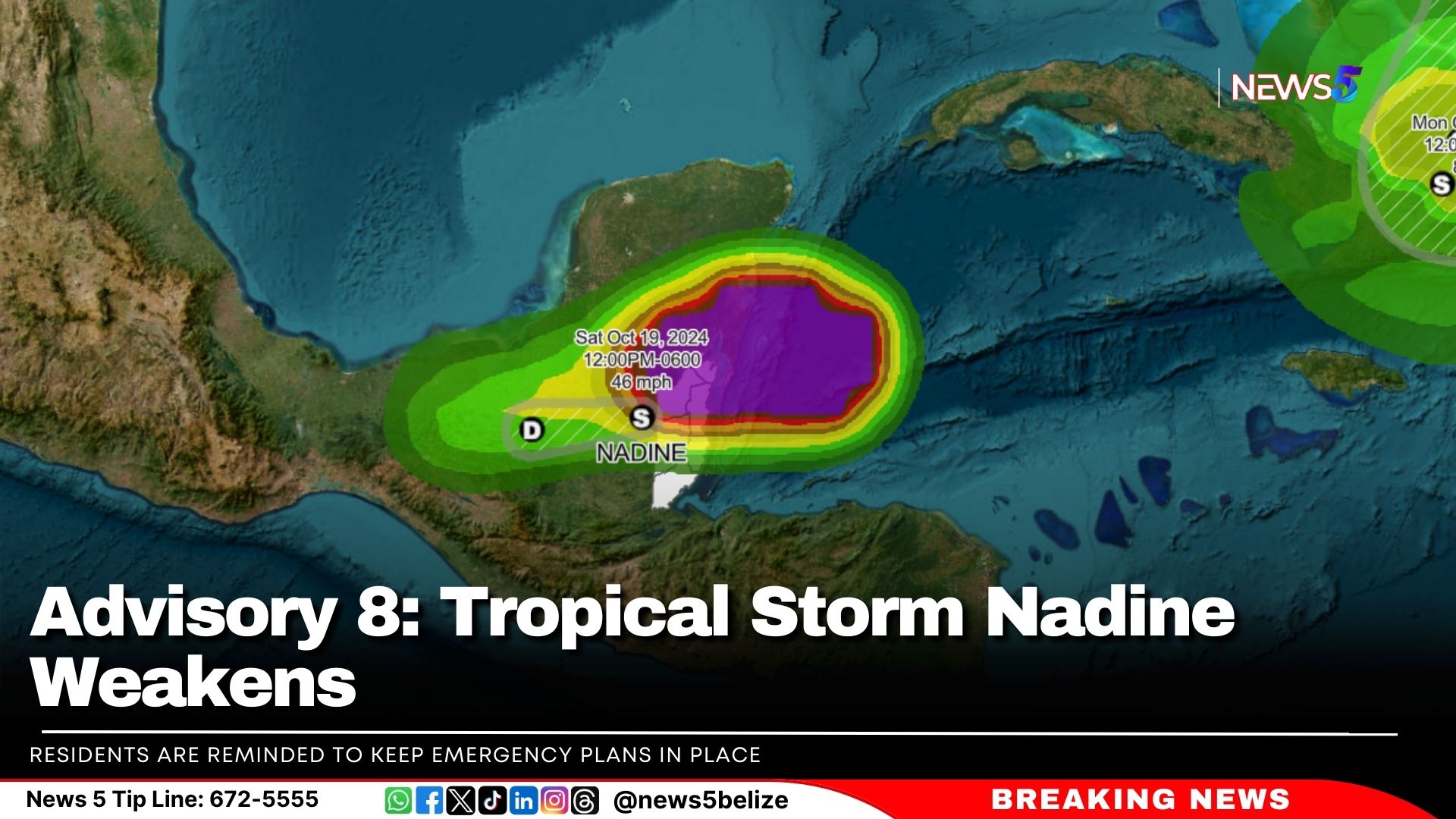
As of 3:00 PM on Saturday, October 19, 2024, Tropical Storm Nadine is gradually weakening as it continues to move inland. Despite this, tropical storm conditions are still affecting parts of the Corozal, Belize, and Orange Walk Districts. A Tropical Storm warning remains in effect from Belize City northward to the Mexico border.
At 3:00 PM, Nadine was located approximately 80 miles west of Belize City at latitude 17.4N and longitude 89.4W, moving westward at 13 mph with maximum sustained winds of 45 mph. This westward motion is expected to continue for the remainder of the day.
The primary concern remains heavy rainfall. Rainfall totals of 3 to 6 inches have already been recorded, with an additional 2 to 4 inches possible, especially over northern and central Belize. This raises the risk of flooding. Strong gusty winds are still creating rough seas, and mariners are advised to stay in safe harbor until the winds die down later this evening. Gusty winds in central and northern districts may continue for the next 2 to 3 hours and could cause minor damage to weak structures.
Hazards Expected to Affect Belize:
– Excess Rainfall: An additional 2 to 4 inches of rain is expected, which could lead to localized flooding in northern and central Belize.
– High Winds: Winds of 45 mph, with stronger gusts, may cause damage to structures, crops, and trees.
Flood Warnings are in Effect for:
– Coastal Road from La Democracia to Hope Creek Junction
– San Ignacio low-level bridge and Iguana Creek Bridge
– Sittee River and surrounding areas
– Rivers in central and northern Belize, including Rio Hondo, New River, Booth’s River, Rio Bravo, Mopan, Macal, and Belize Rivers, as well as those on the eastern slopes of the Maya Mountains.
The National Emergency Management Organization (NEMO) urges residents in the Corozal, Belize, Orange Walk, and Cayo Districts to make use of shelters if necessary. Other districts should remain on high alert. Businesses in the Corozal, Orange Walk, and Belize Districts, including San Pedro and Caye Caulker, should remain closed. Essential services, however, will stay open in these areas.
Residents are reminded to keep emergency plans in place, ensure they have supplies of food, water, and medicine, and check on vulnerable individuals, including the elderly and those with disabilities. Shelters are available in affected districts, and water taxi operations remain suspended.
The Philip Goldson International Airport (PGIA) remains open, but travelers should expect delays.
Hurricane Oscar has formed off the coast of the Bahamas, according to the National Hurricane Center (NHC) in Miami. Characterised as “tiny,” Oscar is currently located approximately 165 miles east-southeast of the Bahamas and about 470 miles east of Camaguey City in Cuba, with maximum sustained winds reaching 80 miles per hour.
In response to the storm, the government of Cuba has issued a Hurricane Watch for the provinces of Guantanamo, Holguin, and Las Tunas.
The latest advisory from the NHC warns of locally heavy rainfall that may affect the Turks and Caicos Islands and the southeastern Bahamas later today, with conditions expected to spread to eastern Cuba by Sunday.
Additionally, the NHC is also monitoring Tropical Storm Nadine, which is currently situated just inland over Belize.
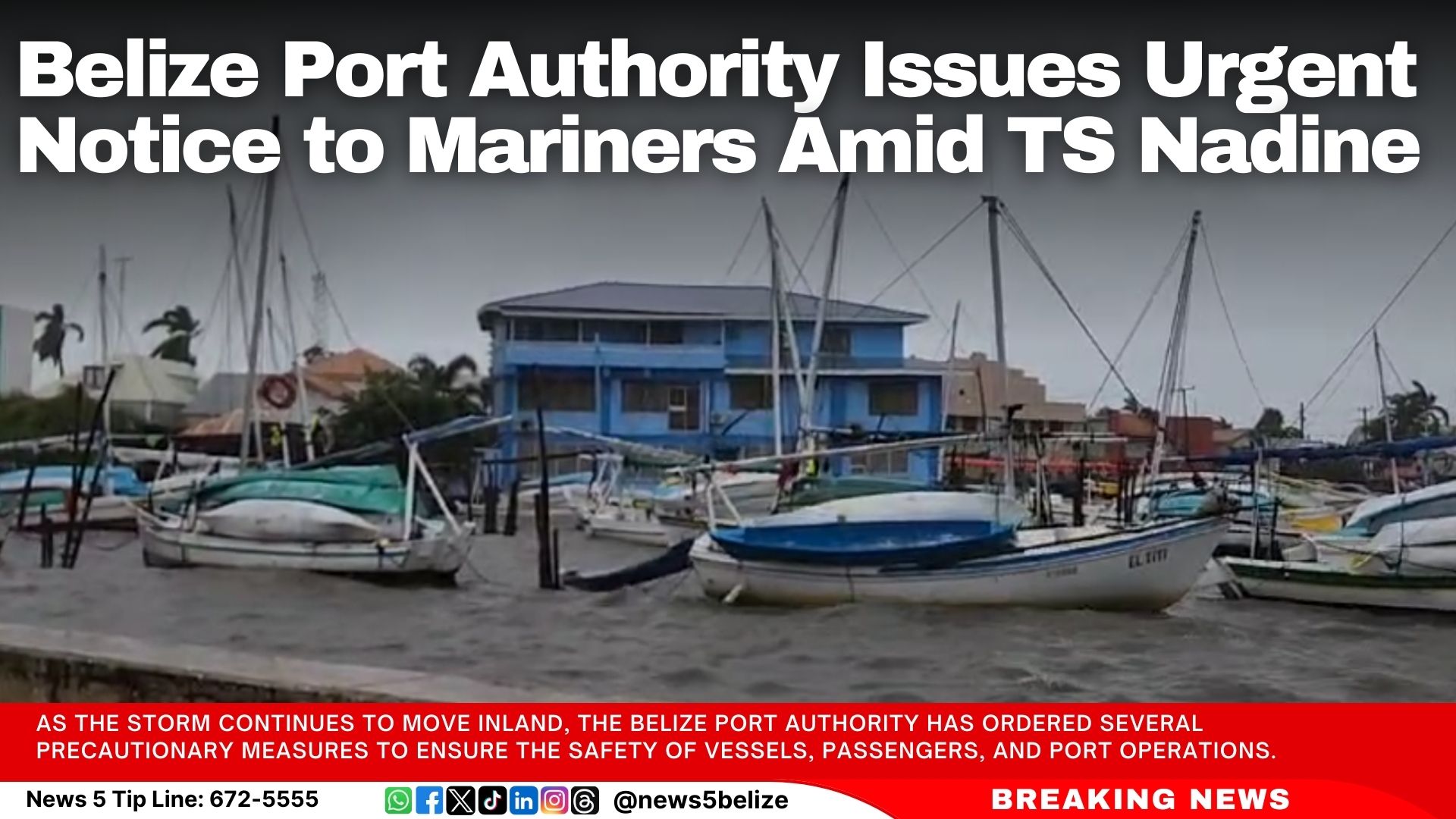
The Belize Port Authority has issued an urgent advisory to all mariners, boat owners, and port facility operators in light of Tropical Storm Nadine, which is currently affecting the country. A Tropical Storm Warning is in effect from Belize City northward to the border with Mexico, bringing heavy rainfall, strong winds, rough seas, and the potential for flooding, particularly in northern and central districts.
As the storm continues to move inland, the Belize Port Authority has ordered several precautionary measures to ensure the safety of vessels, passengers, and port operations.
Suspension of Water Taxi Operations
All water taxi services within the affected areas have been suspended until further notice. Operators are instructed to immediately cease operations and prioritize the safety of passengers and staff.
Guidelines for Vessel Owners and Operators
All vessels in the affected zones are advised to remain moored in safe harbor until the situation improves. Vessel owners should check and secure mooring lines and remove any loose items from decks to prevent damage. Mariners are urged to stay updated on official weather reports and advisories from the Belize Port Authority and the National Emergency Management Organization (NEMO).
Port Facilities Precautions
Port operators in the impacted areas should secure all cargo and fasten loose materials in preparation for high winds and potential flooding. Operations should be limited or suspended if weather conditions deteriorate to unsafe levels.
The Belize Port Authority is closely monitoring the situation and will provide updates as needed. Mariners are encouraged to stay tuned to local radio stations and VHF radio advisories for the latest information.
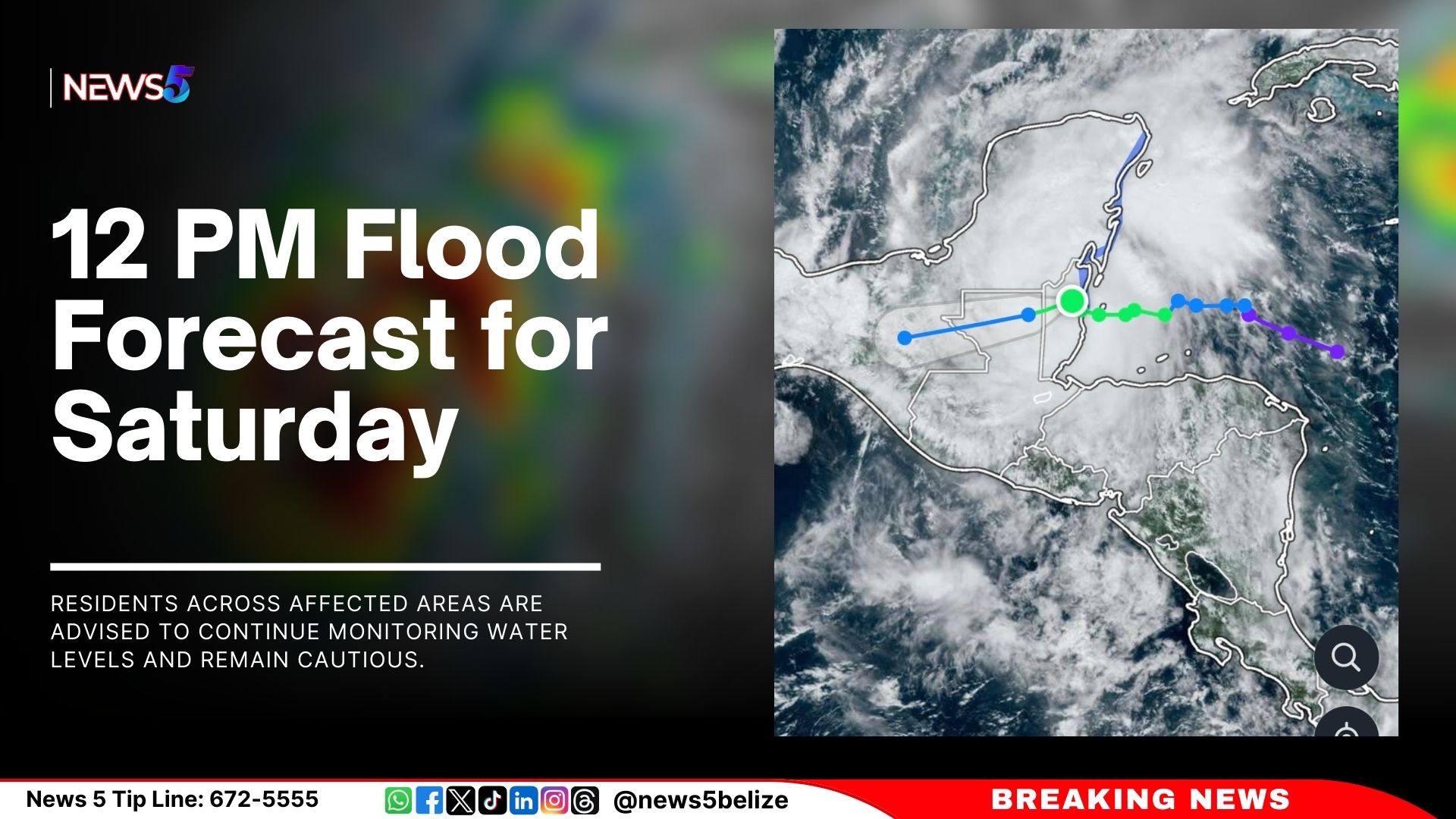
As of 12:00 PM, the flood outlook for the next 24 hours indicates elevated river levels are expected for the Sibun River at Freetown Sibun. In Region 7, residents are urged to monitor water levels and exercise caution. On the Rio Hondo at Blue Creek North, flood levels are expected to continue, with increasing levels forecast downstream at Santa Cruz, San Antonio, San Roman, Douglas, and toward the coast. The New River at Hill Bank and Tower Hill will see rising levels, while elevated levels are expected at Caledonia.
In Region 9, the Mopan River at Benque Viejo Town is expected to reach bank full stage. The Macal River’s Fortis reservoirs at Chalillo and Mollejon are projected to remain below spillway, but Vaca will exceed the spillway, and the low-level bridge at San Ignacio will also be affected. The Belize River at Double Run will see above-normal levels, while the Crooked Tree Lagoon’s levels are expected to remain below the causeway.
In Region 11, the Sibun River at Freetown Sibun will experience increasing but still below-normal levels. The Southern Lagoon at Gales Point Village will see rising levels. Watersheds on the eastern slopes of the Maya Mountains and the Sittee River at Kendal Bridge will continue to see above-normal levels. Below-normal levels are expected for the Swasey and Bladen branches of the Monkey River, while normal levels are forecast for the Deep River at Medina Bank, the Rio Grande at San Pedro Columbia and Big Falls, and the Moho River at Blue Creek South and Jordan. Similarly, the Temash River at Crique Sarco will maintain normal levels.
In Region 13, normal levels are expected on the Sarstoon River. Residents across affected areas are advised to continue monitoring water levels and remain cautious.