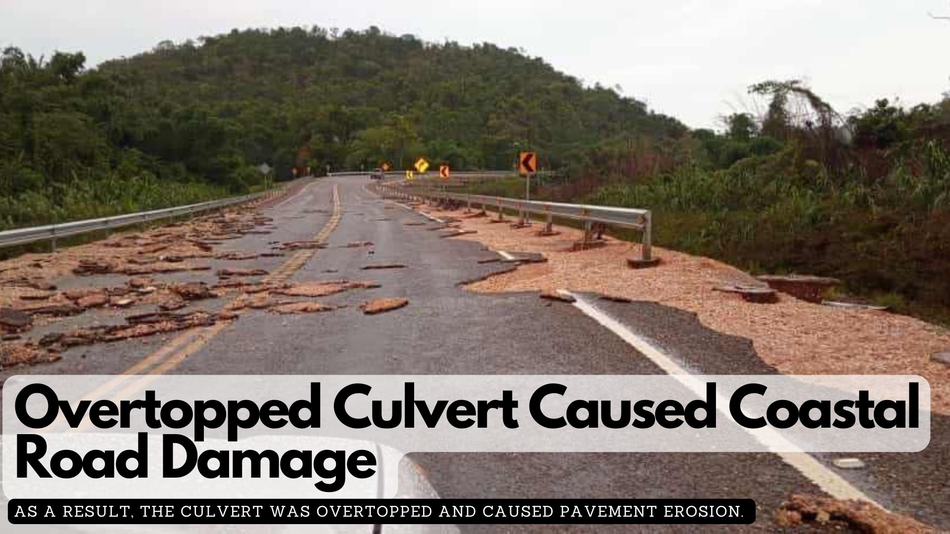
The Ministry of Infrastructure Development and Housing explained that damage to the Coastal Plains Highway was caused by a 3.0m x 1.5m box culvert that was overtopped due to backwater from Soldier Creek, approximately 180m away.
In a press release, the ministry said that this backwater resulted from a blockage in the creek and deforestation caused by recent wildfires, which expanded the catchment areas around the culvert.
“The Road Maintenance Unit of the MIDH, along with the contractor, has been mobilised to execute clean-up and minor restoration works on the pavement. In addition, the MIDH is conducting further assessment of the area to determine any additional contributing factors that forced run-off away from the intended Soldier Creek.”
According to the ministry, this suggests that the culvert’s overtopping and subsequent pavement erosion were due to the unexpected intensity of rainfall and flash flooding, along with debris overwhelming the culvert’s capacity.
Meanwhile, the Ministry of Education announced the “suspension of classes for all levels in the Corozal and Orange Walk Districts for today, 17th June 2024. This suspension is necessary due to excessive rainfall, which has impacted both districts since early this morning.”
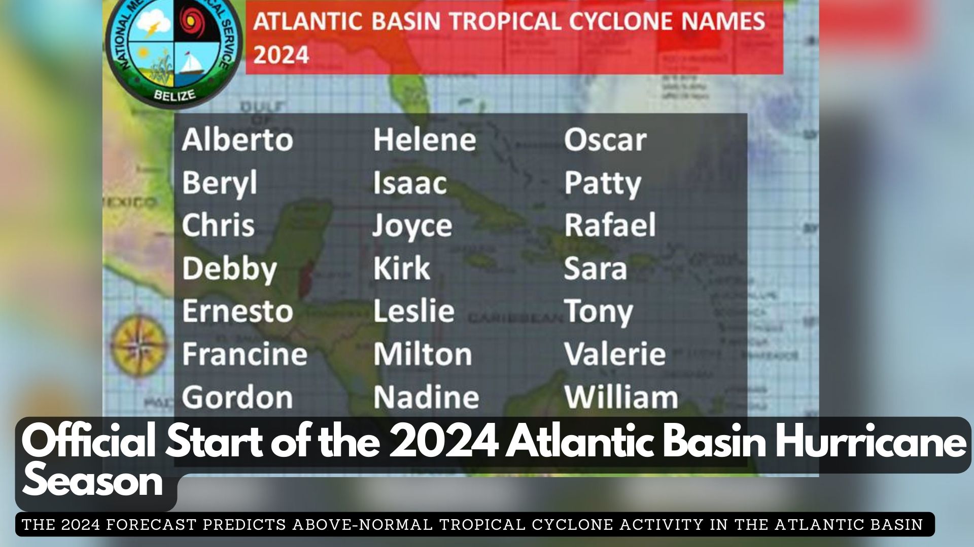
June 1st marks the official beginning of the 2024 hurricane season for the Atlantic Basin, which includes the North Atlantic, Caribbean Sea, and the Gulf of Mexico. This season runs from June 1st to November 30th each year, though tropical cyclones can occasionally form outside this period.
The 2024 forecast predicts above-normal tropical cyclone activity in the Atlantic Basin, with expectations of 17 to 25 named storms. Out of these, eight to 13 are anticipated to become hurricanes, and four to seven are likely to reach major hurricane status (Category 3 or stronger). Typically, an average Atlantic season comprises 14 named storms, seven hurricanes, and three major hurricanes.
Two main factors are expected to influence the 2024 Atlantic hurricane season:
High likelihood of La Niña: Developing during the peak of the season, this phenomenon is likely to enhance tropical cyclone activity in the Atlantic Basin.
Warmer-than-average sea surface temperatures: These temperatures are expected to provide more energy, fueling tropical cyclone development.
What Does this Mean for Belize?
While seasonal predictions indicate the expected activity level of a hurricane season, they do not specify the timing or path of individual hurricanes. Belize, being in a region vulnerable to tropical cyclones, must remain prepared each year regardless of the forecast. Whether one or more of the 17 to 25 named storms predicted this season will impact Belize is uncertain, but preparedness is crucial.
The fourth International Conference on Small Island Developing States (SIDS4) is underway in Antigua. More than 20 world leaders, along with representatives from the private sector, civil society, academia, and youth—nearly 4,000 participants in total—have gathered at the American University to tackle critical issues impacting the future of SIDS.
The fourth International Conference on Small Island Developing States (SIDS4) is underway in Antigua
Under the theme “Charting the Course Toward Resilient Prosperity,” the four-day conference (27-30 May) will showcase innovations and develop practical solutions to address challenges driven by the climate emergency, spiralling debt, and health crises.
The conference will adopt The Antigua and Barbuda Agenda for SIDS (ABAS), a Renewed Declaration for Resilient Prosperity, outlining the sustainable development aspirations of small islands over the next decade and the support required from the international community.
The session began with a recorded message from King Charles III. During his speech, King Charles III said, “I’ve seen the critical challenges you face and how they can multiply to a terrifying and existential degree. I have also seen how islands are leaders. You are continuously showing the world in tackling climate change, in protecting biodiversity and in stewarding incredibly 1/3 of the global ocean which is absolutely crucial in the fight against both climate change and nature loss.”
Secretary-general of the United Nations António Guterres
UN Secretary-General António Guterres, in his opening address, emphasized that SIDS are a “test case for climate justice and financial justice.” He decried the prospect of losing entire countries or cultures due to global warming and the disparities in the global financial system. Guterres called for bold investments from SIDS and substantial support from the international community, particularly from countries with the greatest responsibility and capacity to address these challenges. He underscored the urgency of implementing the Antigua and Barbuda Agenda for SIDS and demanded a fair and just global financial architecture.
SIDS, spanning the Pacific, Caribbean, Atlantic, Indian Ocean, and South China Sea, are home to approximately 65 million people and manage 19.1 percent of the world’s Exclusive Economic Zones. Despite their high biodiversity and significant contributions to renewable energy, sustainable tourism, and conservation, these nations face unique vulnerabilities due to their small size, remote locations, and susceptibility to climate-induced disasters.
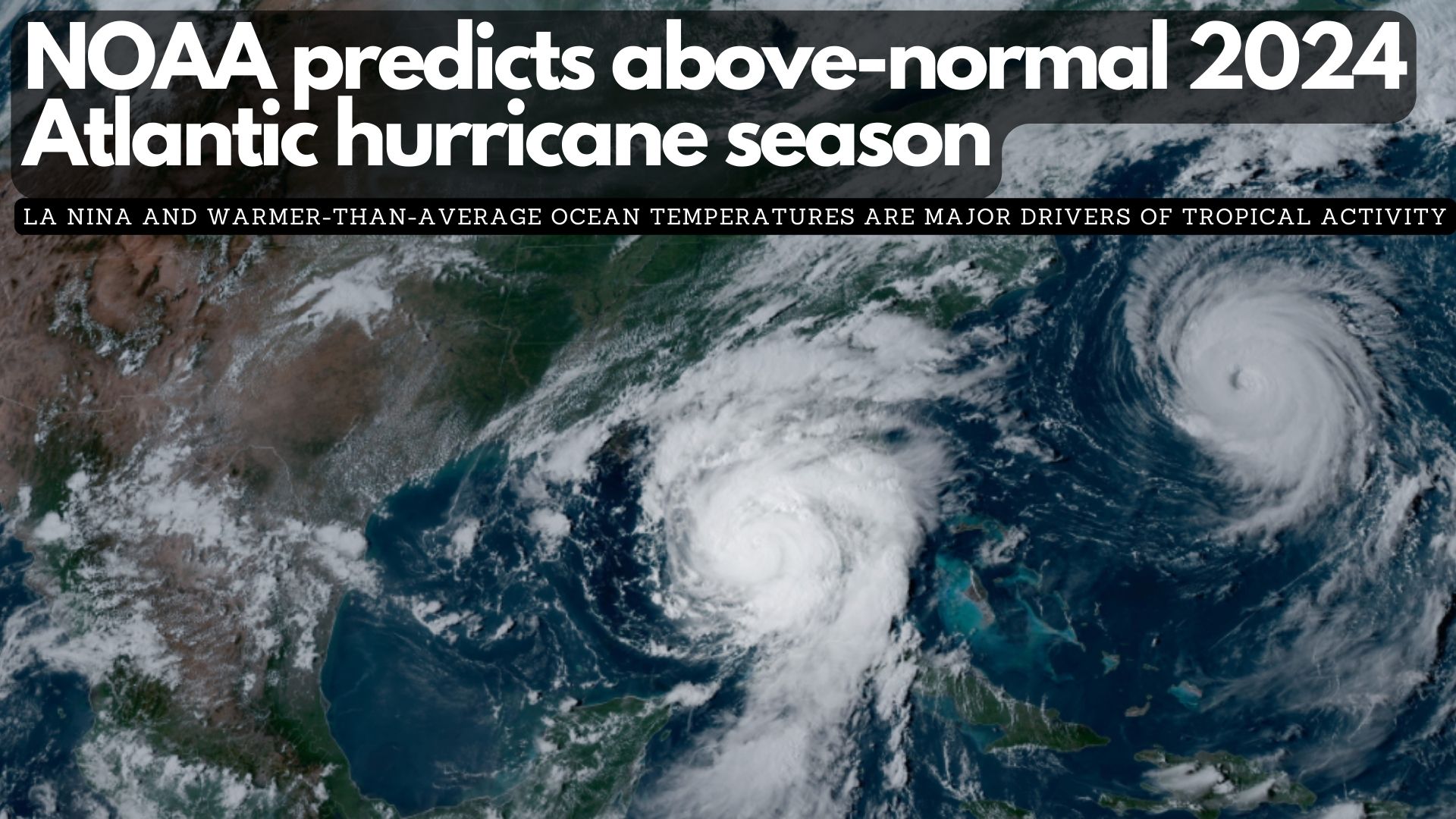
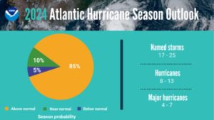
NOAA National Weather Service forecasters at the Climate Prediction Center predict above-normal hurricane activity in the Atlantic basin this year. NOAA’s outlook for the 2024 Atlantic hurricane season, which spans from June 1 to November 30, predicts an 85% chance of an above-normal season, a 10% chance of a near-normal season and a 5% chance of a below-normal season.
NOAA is forecasting a range of 17 to 25 total named storms (winds of 39 mph or higher). Of those, 8 to 13 are forecast to become hurricanes (winds of 74 mph or higher), including 4 to 7 major hurricanes (category 3, 4 or 5; with winds of 111 mph or higher). Forecasters have a 70% confidence in these ranges.
The upcoming Atlantic hurricane season is expected to have above-normal activity due to a confluence of factors, including near-record warm ocean temperatures in the Atlantic Ocean, development of La Nina conditions in the Pacific, reduced Atlantic trade winds and less wind shear, all of which tend to favor tropical storm formation.
A summary infographic showing hurricane season probability and numbers of named storms predicted from NOAA’s 2024 Atlantic Hurricane Season Outlook. (Image credit: NOAA)
“With another active hurricane season approaching, NOAA’s commitment to keeping every American informed with life-saving information is unwavering,” said NOAA Administrator Rick Spinrad, Ph.D. “AI-enabled language translations and a new depiction of inland wind threats in the forecast cone are just two examples of the proactive steps our agency is taking to meet our mission of saving lives and protecting property.”
“Severe weather and emergencies can happen at any moment, which is why individuals and communities need to be prepared today,” said FEMA Deputy Administrator Erik A. Hooks. “Already, we are seeing storms move across the country that can bring additional hazards like tornadoes, flooding and hail. Taking a proactive approach to our increasingly challenging climate landscape today can make a difference in how people can recover tomorrow.”
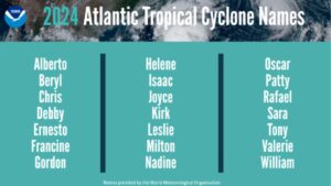
A summary graphic showing an alphabetical list of the 2024 Atlantic tropical cyclone names as selected by the World Meteorological Organization. The official start of the Atlantic hurricane season is June 1 and runs through November 30. (Image credit: NOAA)
As one of the strongest El Ninos ever observed nears its end, NOAA scientists predict a quick transition to La Nina conditions, which are conducive to Atlantic hurricane activity because La Nina tends to lessen wind shear in the tropics. At the same time, abundant oceanic heat content in the tropical Atlantic Ocean and Caribbean Sea creates more energy to fuel storm development.
This hurricane season also features the potential for an above-normal west African monsoon, which can produce African easterly waves that seed some of the strongest and longer-lived Atlantic storms. Finally, light trade winds allow hurricanes to grow in strength without the disruption of strong wind shear,and also minimize ocean cooling. Human-caused climate change is warming our ocean globally and in the Atlantic basin, and melting ice on land, leading to sea level rise, which increases the risk of storm surge. Sea level rise represents a clear human influence on the damage potential from a given hurricane.
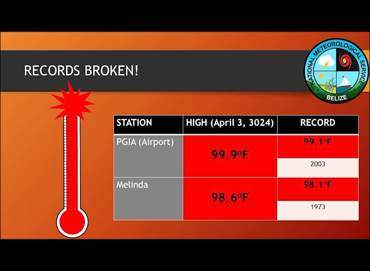
Belize has been experiencing some extremely hot days over the last few weeks. In fact, two all-time heat records were broken only last week. The National Meteorological Service of Belize warns that above seasonal temperatures are expected to continue across the county over the next few months, with as many as fifty heat wave days expected inland. Chief Meteorologist Ronald Gordon told us more.
Ronald Gordon
Ronald Gordon, Chief Meteorologist, National Meteorological Service
“As we reported last week we had two stations in this country that broke all time records on the second of, or it was the third, last week Wednesday. We had a record here at the airport which we never experienced before, which is a hundred degrees Fahrenheit and ninety-nine point nine to be exact. That is an all-time record for this station. We had another record in Melinda. I cannot recall the exact figure but that was also a record that was broken an all-time record on that same day. So it shows you that that day was extremely hot across the country and if that is any indication of what is going to happen in the peak of the dry season then we can expect it to be a record hot year for us this particular heat season. To put it precisely one of the things that is favoring that excessive heat is the very warm ocean temperatures. We know that the air is modified by the oceans. So, certainly given the fact that we have very warm ocean temperatures mean we are going to have very warm atmospheric temperatures near the surface.”
The National Meteorological Service of Belize may soon be faced with a shortage of personnel. With senior employees retiring, filling their positions presents a challenge as it requires studying abroad to meet the qualifications in the field. Chief Meteorologist Ronald Gordon addressed the issue on Monday, emphasizing the urgent need for replacements for those who are retiring.
Ronald Gordon, Chief Meteorologist, National Meteorological Service
“To be honest we had one additional person coming on board and that was last year. So, in terms of our forecasting team it has not increased that much. We do hope people would become interested in this field. We are in a situation where several of our senior personnel have retired or are about to retire and we need to replacements. So it is something we do encourage. In terms of the gender balance, I would say it has flipped. First, we had more males in the field. But, certainly at this point in time, in terms of the technical persons, we have more females in this field. We encourage persons of all gender to join. We do outreach to different schools at different times to try to encourage students to become interested in the field of meteorology and we would hope it would be something that would take off. One of the difficulties we have is that this field is not offered in Belize or not taught here so persons needs to go abroad to qualify and that is one of the things that hinders us to recruit more personnel.”
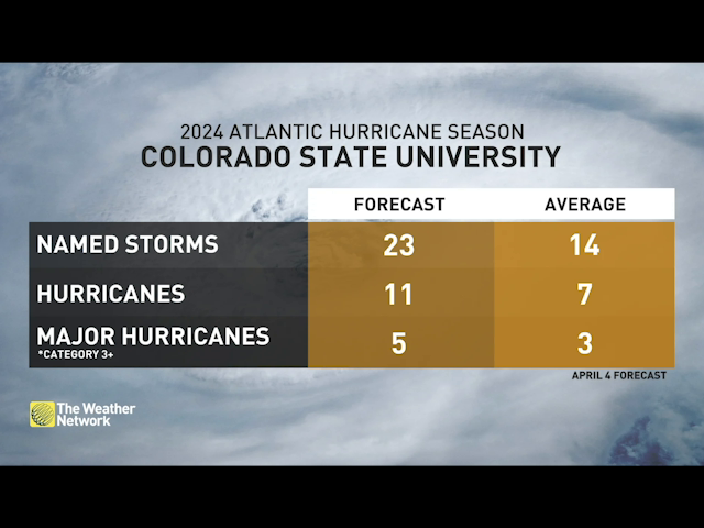
This year’s Atlantic hurricane season is expected to be the most active ever recorded. Two months ahead of the official start of the season, a team of experts from Colorado State University is forecasting twenty-three named storms, including eleven hurricanes and five major hurricanes. Forecasters are pointing to two main factors that could contribute to an extremely active hurricane season: historically warm ocean temperatures and an impending La Nina. Meteorologists, including those in Belize, hold the university’s forecast in high regard because of the team’s accuracy in their reports. So, today we spoke with Chief Meteorologist, Ronald Gordon, about what Belize can expect this hurricane season.
Ronald Gordon
Ronald Gordon, Chief Meteorologist, National Meteorological Service
“The forecast from Colorado State University has been issued and they’re predicting a very active, 2023 Atlantic Hurricane season. If my memory serves me right, the figure they issued is for twenty-three named storms, eleven hurricanes, and about five major hurricanes. That forecast is early, preliminary. We are in April and from what we have seen in the past there is some limited skills to those early season forecast. Notwithstanding that CSQ has indicated they have an above normal confidence in this forecast and the reason for this is because the predictors are suggesting it is going to be quite active. In terms of what it means for Belize, whenever you have the odds for a higher than normal season it would indicate that the odds for us are also higher than normal that one could come our way. So we know that the twenty-three named storms that are predicted all of them will not come here or go in one direction, that is a prediction for the entire basin. However, because you know that it is a super active season, the odds of us having one is increased. The figures I have from CSU is that the typical average for us getting a named storm within fifty miles of our coastline, the average is at forty-two percent. This year it is at sixty percent. So there is a higher probability of a storm coming near to us. And one thing I failed to mention in terms of the total numbers is the average. The average for their to fourteen named storms, of those fourteen seven typically becomes hurricanes and three of those become major hurricanes and that is an average over the last thirty years from 1991 to 2020.”
As we mentioned, the 2024 Atlantic hurricane season does not officially begin until the first of June. But early forecasts like the one coming out of Colorado State University provide an opportunity to review hurricane plans way in advance. Chief Meteorologist Ronald Gordon is advising the nation to do just that. He warns that those living along coastal Belize should especially put mitigating measures into place to reduce risks.
Ronald Gordon, Chief Meteorologist, National Meteorological Service
“To mention at this point what level of preparations people should do is at this point you want to review your hurricane plan. We are still of course I believe about two months plus from the start of the hurricane season. We do know that you could have systems out season as well, but the official start is on June the first, so what we encourage our residents to always do is ensure that you are fine tuning those plans at the moment to know what measures you will take, whether you will need to evacuate, what measures you will need to take to reinforce your house to withstand at least a category two or three hurricane or even a major hurricane for that matter and also if you are able to afford insurance now is a good time to look at it because the prediction is going for an active season and as I mentioned before, that means there is a higher risk of one coming our way. So if you can afford insurance that is a good thing to look at and that type of thing nuh to ensure you are prepared for the event that sort of thing comes your way. In terms of any particular part of the country, we do know that our entire coastline is vulnerable to hurricanes. There is no doubt about it. If you are way down south, Punta Gorda and below, it is rare that you can any sort of direct landfall. We do know that you have secondary effects from systems making landfall in Central America, which includes excessive rainfall. So to summarize, there is no particular location on the coast of Belize that is exempt. It is important that all communities that are in the direct path of these systems prepare in advance and take measures to mitigate any possible impact from any possible landfall system this season.”
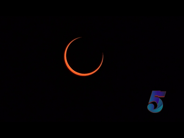
The total solar eclipse that occurred today in some parts of Mexico, the U.S., and Canada was only a partial one in most other countries. In Belize, for those who tried to capture the event, it was a mere forty percent blockage of the sun by the moon. But your efforts might have been in vain, depending on where you were, because some parts of the country were cloudy just as the eclipse was occurring around eleven-eighteen this morning. Chief Meteorologist, Ronald Gordon said the sky did get dark, but cloud cover was an issue to contend with.
Ronald Gordon
Ronald Gordon, Chief Meteorologist, National Meteorological Service
“I certainly don’t have the specialized equipment to go there and look at the sun. So I did not do that. But I want to say that, from my own observation, it got a bit darker. I think it wasn’t that significant that I had predicted, or as we had mentioned, I believe before that it was a 40 percent occlusion for this particular eclipse, a partial eclipse. So we didn’t expect it to even be as dark as the one that we had in October last year, which had more. Obstruction or occlusion, so certainly it wasn’t as dark as that 1 and I think unfortunately for residents in my area. I don’t know about where. The entire country, but certainly in Belize today, even with a little area, it was a bit cloudy. So certainly if you had the. The specialized sunglasses to go there and look at it, it may have been a bit disappointing because for the most part, it was a bit cloudy.”
The upcoming total solar eclipse in North America is scheduled for Monday, April eighth. The totality will last up to four minutes and will span across Mexico, the United States, and Canada. For those outside the path of totality, a crescent-shaped partial eclipse will still offer a mesmerizing view. While Belize won’t experience the total phase of the eclipse, it will witness a partial solar eclipse, beginning at eleven-eighteen with the first contact between the Moon and the Sun’s edge. We spoke with Chief Meteorologist Ronald Gordon, who gave us some more information.
Ronald Gordon
Ronald Gordon, Chief Meteorologist, National Meteorological Service
“As it relates to this particular eclipse that will occur actually on Monday, the eighth of April believes is not within the path of totality, which means that we are not going to experience a total solar eclipse. However, we are going to see a partial solar eclipse. From what I’m seeing. We are going to be about forty percent of occlusion, which means that about forty percent of the sun will be covered by the moon. And that indicate that it will not be very dark. You may recall that we had an annular solar eclipse in October of last year. And that was an eclipse in which the moon basically was within the entire part of the or entire coverage of the sun. But there was that. Ring around it because at that point, the distance between the moon and the earth was not close enough for it to entirely cover the sun. So it’s not a total eclipse, but rather described as an annular solar eclipse. In this case, there’ll be even less coverage. In other words, there’ll be even less blockage of the sun, so it will not even be as dark as it was. For the clips that we saw last year. Now, in terms of timing, the information that I have is that it will be starting around about eighteen minutes after eleven here local time. The maximum coverage will be about twelve thirty-one and by about one forty-five or so more or less. It will be all clear. Weather conditions currently, although it’s a bit far away, indicate that we’ll be under an easterly flow. There’s a possibility of isolated showers and the possibility of some cloudiness. We cannot tell for sure if at that particular time, it will be cloudy or not. It’s not possible to see that. But if it is not cloudy, and you’re able to look at the sun, which we advise you to do with specialized sunshades. You will maybe see that there’s an obstruction between the earth and the sun. You’ll see the shadow of the moon, basically, not the shadow, but the actual moon obscuring part of the sun. If you look up, if you are not able to look up with those specialized sunshades, you may not even know that there’s something covering the sun. It may look like a cloud or something, or it might be the level of darkness will not be that significant for you to know that there’s an eclipse occurring. That’s what we expect it to look like at that time.”