Potential Tropical Development in Caribbean and Atlantic

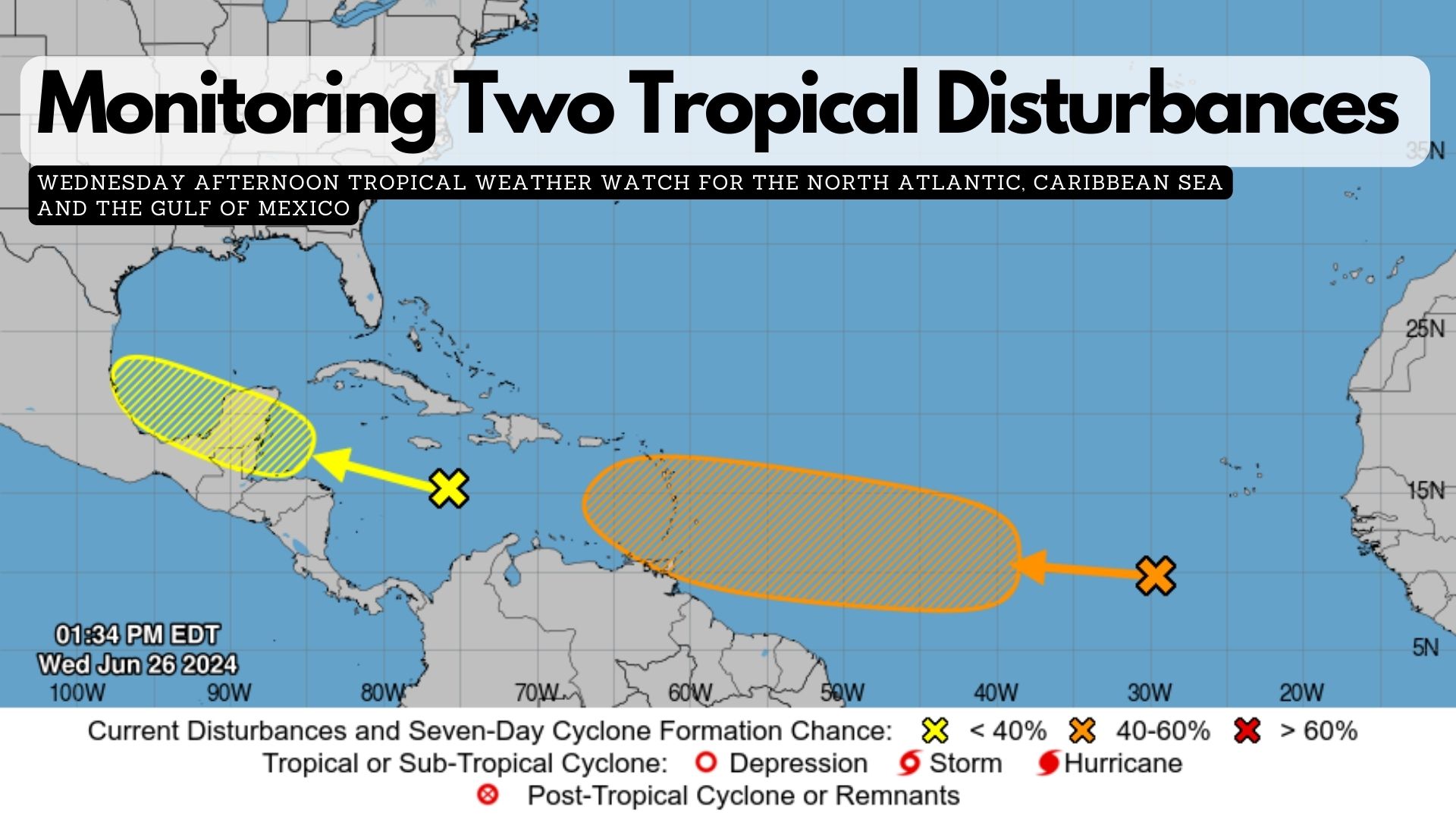
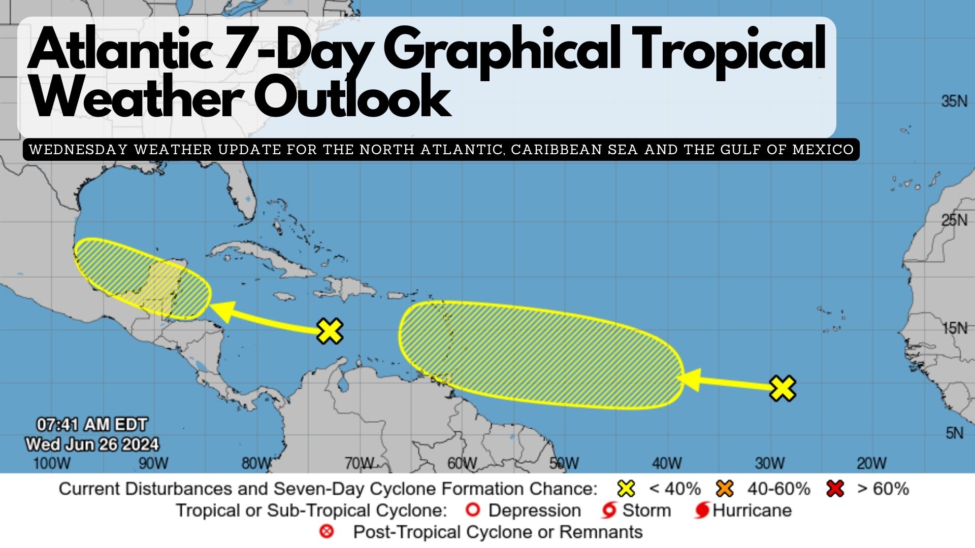
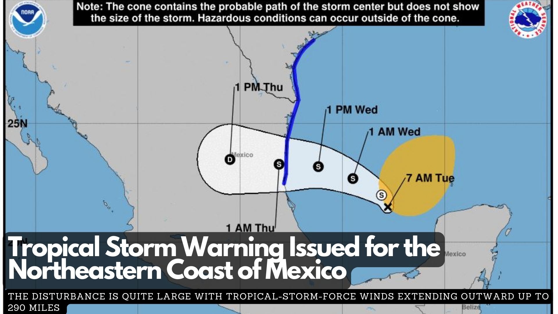
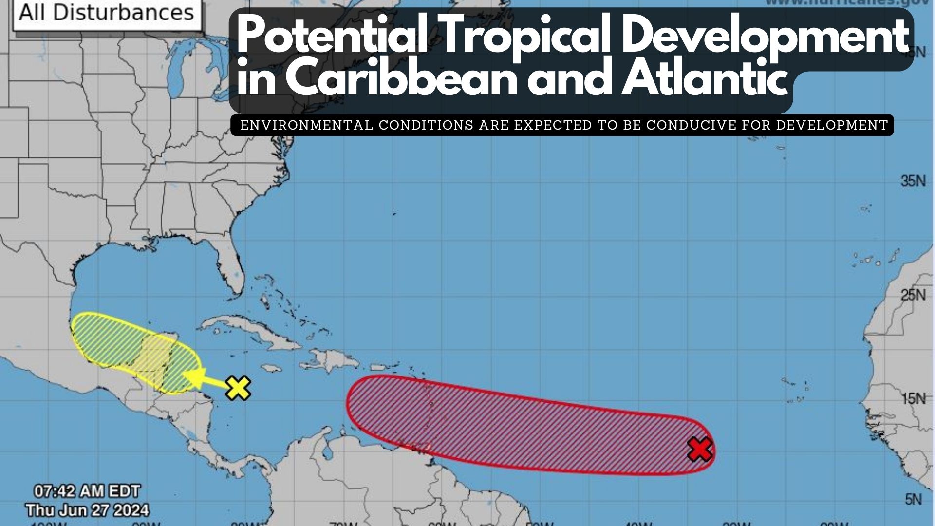
This Thursday, a tropical wave in the western Caribbean Sea is creating widespread but disorganized showers and thunderstorms as it moves westward at about 20 mph. Some development of this system is possible over the northwestern Caribbean Sea or the southwestern Gulf of Mexico in the coming days. It has a low chance (10%) of formation in the next 48 hours and a low chance (30%) in the next 7 days.

Meanwhile, a tropical wave several hundred miles west-southwest of the Cabo Verde Islands continues to produce disorganized showers and thunderstorms. Environmental conditions are expected to be conducive for development, and a tropical depression or tropical storm is likely to form this weekend several hundred miles east of the Windward Islands as the system moves westward at 15 to 20 mph. It has a medium chance (40%) of formation in the next 48 hours and a high chance (70%) in the next 7 days.

Monitoring Two Tropical Disturbances 

(2 p.m. update) Meteorologists from the National Hurricane Center in Miami are closely monitoring two disturbances that could potentially develop into tropical cyclones.

Western Caribbean/Southwestern Gulf of Mexico:
The first disturbance is currently a tropical wave sweeping through the central Caribbean Sea at a brisk pace of twenty-five miles per hour. While shower activity remains disorganised, conditions are expected to become more favourable for gradual development over the weekend. There is a possibility that this system could intensify over the western Caribbean Sea or the southwestern Gulf of Mexico.
* Formation chance through 48 hours…low…10 percent.
* Formation chance through 7 days…low…20 percent.

Eastern Tropical Atlantic:
Meanwhile, a second tropical wave located southwest of the Cabo Verde Islands is also under scrutiny. This system is generating scattered showers and thunderstorms and has the potential to strengthen over the next few days. Forecasters indicate that a tropical depression could potentially form in the eastern tropical Atlantic by the end of the week or into the weekend as it moves westward at 15 to 20 mph.
* Formation chance through 48 hours…low…near 10 percent.
* Formation chance through 7 days…medium…40 percent.

Atlantic 7-Day Graphical Tropical Weather Outlook

As of 8:00 AM EDT on Wednesday, June 26, 2024, the National Hurricane Center in Miami, Florida, has identified two areas of interest in the Atlantic basin that could potentially develop into tropical systems over the coming days.

Western Caribbean/Southwestern Gulf of Mexico:
The first area of concern is a tropical wave currently situated over the central Caribbean Sea. This system is moving rapidly westward at approximately 25 mph, accompanied by disorganised shower activity. There is a possibility that environmental factors may improve by the weekend.
* Formation chance through 48 hours…low…10 percent.
* Formation chance through 7 days…low…20 percent.

Eastern Tropical Atlantic:
The second area being monitored is a tropical wave located several hundred miles southwest of the Cabo Verde Islands. This disturbance is generating disorganised showers and thunderstorms as it moves westward across the central and western tropical Atlantic at a speed of 15 to 20 mph.
* Formation chance through 48 hours…low…near 0 percent.
* Formation chance through 7 days…low…30 percent.

Atlantic 7-Day Graphical Tropical Weather Outlook

The NWS National Hurricane Center in Miami, FL, has issued a tropical weather outlook for the North Atlantic, Caribbean Sea, and Gulf of Mexico as of 2:00 PM EDT on Tuesday, June 25, 2024. A tropical wave currently located over the southeastern Caribbean Sea is generating disorganized showers and thunderstorms while moving quickly westward at approximately twenty-five miles per hour. Environmental conditions may become conducive to gradual development of the system once it reaches the western Caribbean Sea later this week, with potential for further development over the southwestern Gulf of Mexico during the weekend. The chance of formation through the next forty-eight hours is low at 10 percent, and the chance of formation over the next seven days is also low at twenty percent.

Atlantic 7-Day Graphical Tropical Weather Outlook

Tropical Weather Outlook

NWS National Hurricane Center Miami FL
2:00 PM EDT Mon Jun 24, 2024

For the North Atlantic, Caribbean Sea, and the Gulf of Mexico:

Western Caribbean/Southwestern Gulf of Mexico:

A westward-moving tropical wave, located a few hundred miles east-southeast of the Windward Islands, is producing disorganized showers and thunderstorms. Environmental conditions appear conducive for slow development once the wave reaches the western Caribbean late this week.

Formation chance through 48 hours: low, near 0 percent
Formation chance through 7 days: low, 20 percent

Coastal Plains Highway Open for Access

The Ministry of Infrastructure Development and Housing advises the public that water has receded, and the Coastal Plains Highway is now open for access. Road conditions will continue to be closely monitored as further rainfall is expected throughout the weekend. The MIDH thanks all road users for their patience and cooperation and reminds all to drive with care and attention, take note of the gauges present at the floodways that indicate water depth, use seat belts, adhere to the posted speed limits, do not drink and drive and do not text and drive.

(Press release) 

Coastal Road Impassable 

The Coastal Plains Highway is currently impassable, the Ministry of Infrastructure Development and Housing (MIDH) informed in a press release earlier this morning.

It said the highway is “impassable for small vehicles as a result of heavy rainfall and associated flooding over the past 24 hours.”

The Manatee Bridge, Corn House Creek Bridge approaches, and two of the four concrete floodways are submerged under approximately 24 to 30 inches of water. However, the water levels are receding quickly. The MIDH has deployed its maintenance team to monitor the situation and undertake remedial work in these critical areas.

Further updates will be provided throughout the day. Motorists are advised to use the Hummingbird Highway for southbound travel and to drive cautiously, adhering to posted speed limits.

Tropical Storm Alberto Claims Lives Across Mexico and Southern Texas

At least three lives were claimed by the first named storm of the Atlantic hurricane season, Tropical Storm Alberto, after making landfall along the Mexican coast and southern Texas, the BBC reports. The three deaths occurred in the northern Nuevo León state due to the rains brought by the system. According to the Mexican government, one of them, age fifteen, drowned while trying to retrieve a ball in the La Silla River, south of Monterrey. The other two, both ages twelve, died from an electric shock in the municipality of Allende. The three deaths were confirmed by  Nuevo León’s governor, Samuel García, Telemundo reported.

In response to the situation, García implemented a temporary halt to public transportation, while schools in nearby Tamaulipas have been shut down. Meanwhile, Texas Governor Greg Abbott issued a disaster declaration over the border in Texas, saying that “widespread and severe property damage, injury, and loss of life” are possible. Although the system has been upgraded from a tropical cyclone, there are warnings of “life-threatening” flooding and possible mudslides in north-eastern Mexico and southern Texas.

Tropical Storm Alberto Forms

Tropical Storm Alberto formed on Wednesday in the southwestern Gulf of Mexico, marking the first named storm of what is expected to be a busy hurricane season. According to the National Hurricane Center in Miami, Alberto was positioned 185 miles east of Tampico, Mexico, and 295 miles south-southeast of Brownsville, Texas, with top sustained winds of 40 mph. A tropical storm has sustained winds between 39 and 73 mph; beyond that range, it becomes a hurricane.

The storm was moving west at 9 mph.

The National Oceanic and Atmospheric Administration forecasts a well above-average hurricane season, which began on June 1 and runs through November 30. They predict between 17 and 25 named storms, with up to 13 hurricanes and four major hurricanes. In comparison, an average Atlantic hurricane season typically produces 14 named storms, seven hurricanes, and three major hurricanes.


Tropical Storm Warning Issued for the Northeastern Coast of Mexico

At 700 AM CDT (1200 UTC), the disturbance was about 355 miles (575 km) east-southeast of La Pesca, Mexico. The system is moving toward the north near 6 mph (9 km/h). A gradual turn toward the west-northwest and west is expected is expected tonight and Wednesday, and the system is likely to approach the western Gulf coast late Wednesday. Maximum sustained winds remain near 40 mph (65 km/h) with higher gusts.

Some increase in strength is likely during the next 36 hours, and the disturbance is forecast to become a tropical storm by Wednesday. It has a high (80 percent) chance of formation during the next 48 hours and the next 7 days.

The disturbance is quite large with tropical-storm-force winds extending outward up to 290 miles (465 km) to the northeast of the center.

RAINFALL: Potential Tropical Cyclone One is expected to produce rainfall totals of 5 to 10 inches across northeast Mexico into South Texas, with maximum totals of 15 inches possible. This rainfall will likely produce flash and urban flooding along with new and renewed river flooding. Mudslides are also possible in areas of higher terrain across northeast Mexico.

STORM SURGE: The combination of a dangerous storm surge and the tide will cause normally dry areas near the coast to be flooded by rising waters moving inland from the shoreline. The water could reach the following heights above ground somewhere in the indicated areas if the peak surge occurs at the time of high tide…

Exit mobile version