A flood warning remains in effect for the Belize City area as floodwaters continue to flow down the Belize River system, posing a risk of rising water levels in the region.
Region 7:
On the Rio Hondo at Blue Creek North, Santa Cruz, San Antonio, and San Roman, normal water levels are expected. However, from Douglas downstream to the coast, above-normal levels will continue. On the New River at Hill Bank, Tower Hill, and Caledonia, above-normal levels are anticipated.
Region 9:
On the Mopan River at Benque Viejo Town, water levels are expected to remain at the bankfull stage. On the Macal River, reservoir levels at all FORTIS facilities will remain below the spillway, and at San Ignacio, above-normal levels will stay below the low-level bridge. On the Belize River at Double Run, above-normal levels will persist. At Crooked Tree Lagoon, increasing levels are expected but will remain below the causeway.
Region 11:
On the Sibun River at Freetown Sibun, normal water levels are expected. At the Southern Lagoon near Gales Point Village, above-normal levels are forecast. Watersheds on the Eastern Slopes of the Maya Mountains will see above-normal levels, and at Kendal Bridge on the Sittee River, the same trend is expected. On the Swasey and Bladen branches of the Monkey River, below-normal levels are anticipated, while the Deep River at Medina Bank will see normal levels. The Rio Grande at San Pedro Columbia and Big Falls South will experience below-normal levels, as will the Moho River at Jordan. Meanwhile, normal levels are forecasted for the Moho River at Blue Creek South and the Temash River at Crique Sarco.
Region 13:
On the Sarstoon River, normal levels are expected.
Residents in low-lying areas of Belize City are advised to remain vigilant as floodwaters continue to move down the Belize River.
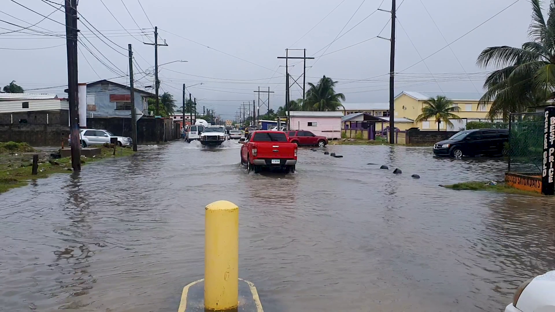
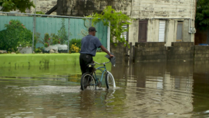
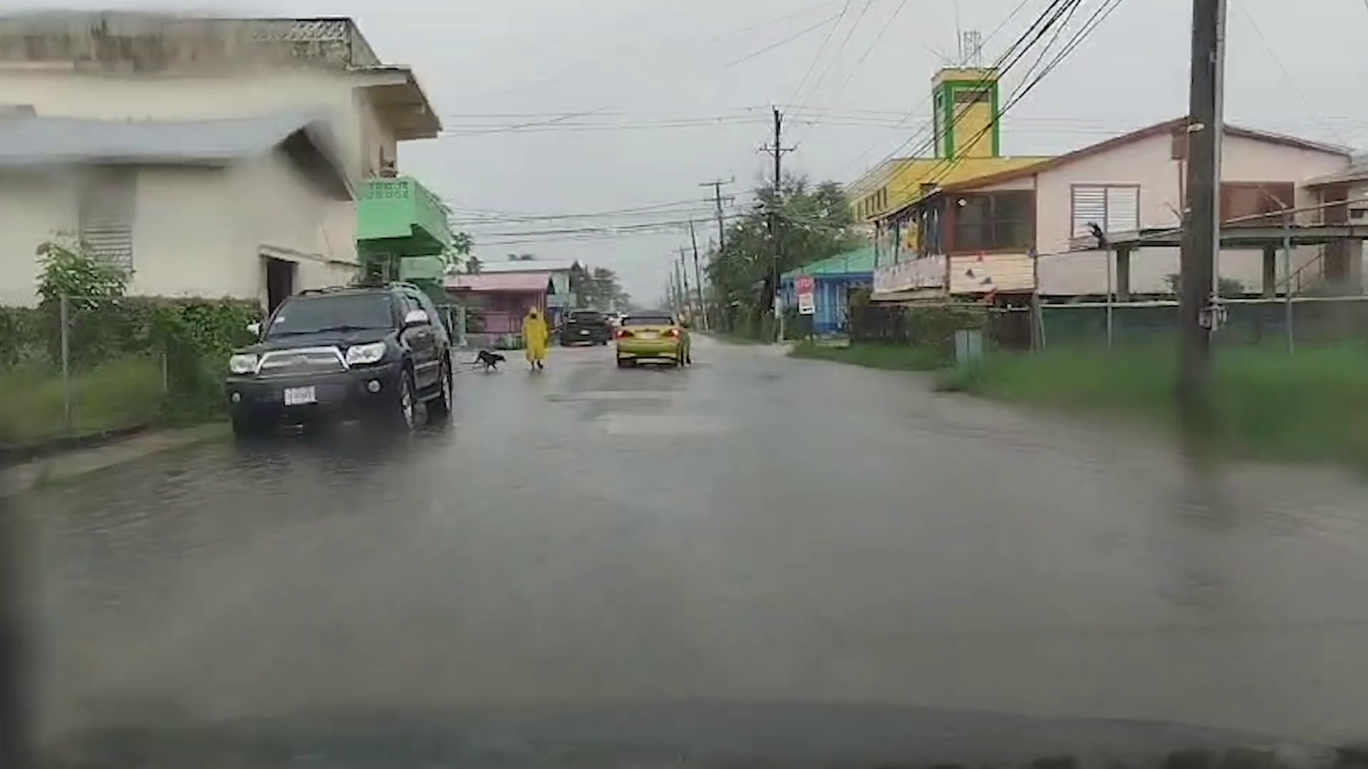
Belize City was under water for the most part of the morning. After a heavy, early morning downpour brought on by a tropical wave, numerous streets were inundated by floodwaters. Classes had not been called off, and so students made their way to school. That is until institutions across the country began sending kids home due to the weather. Floodwater was a major inconvenience to pedestrians and low vehicles alike, but most people pressed on. The Belize City Pumping Station was activated and according to the experts, it helped to decrease floodwaters along key streets in downtown Belize City. News Five’s Paul Lopez went out early this morning. Here is what he found.
Paul Lopez, Reporting
A few hours of downpour on Friday morning led to flooding across Belize City. Vehicles and pedestrians alike had to traverse through several inches of water along main thoroughfares. One woman was seen cautiously stepping off the sidewalk and unto the street with water above her ankles on Mahogany Street. The downpour and flood led many schools to call off classes for the day and send students home.
Darwin Retreage
Darwin Retreage, Belize City Resident
“You guh round and tek a circle around there, you will see a lot of people downstairs, a lot of people yard flood out. We yard flood out, it flood.”
Paul Lopez
“What you think happens if the rain continues like this?”
Darwin Retreage
“Well if it continues people downstairs house flood out. Deh wah have to deal with people appliance and carpet and so.”
Kerry Sandoval
Kerry Sandoval, Belize City Resident
“Cho everywhere flood boss, everywhere. Watch how high the water, right now my yard flood. You cant even walk. Flooded bad, watch yah when I walk this morning I the look to slip down because the yard flood.”
In response to the floods, Belize City Mayor Bernard Wagner left his office and hit the streets to assess the situation firsthand. We met him at the Yabra Pumping Station. The station came on line in October 2023 to mitigate flooding in the Old Capital.
Bernard Wagner
Bernard Wagner, Mayor, Belize City
“Obviously as you can see here, the four screws are working efficiently. Really putting out like one cubic meter per screw. So, we are looking at four cubic meter per second of water being pulled. As we sit, based on the engineers, this is just taking off the top of the water currently. We have not locked off the gates as yet, because water is being pushed out in its natural form in different areas of the city.”
Ramon Menjivar, the Assistant City Engineer, further explained that the pumping station should reduce the floodwater’s runoff time by fifty percent.
Ramon Menjivar
Ramon Menjivar, Assistant City Engineer, Belize City Council
“The system allows us to activate the pumps and get the water much faster, not necessarily much faster than what is dropping, because you have to compare the rainfall dropping on a land mass, as compared to the facility of the pumping action.”
Paul Lopez
“What should be people’s expectations in terms of how fast the water should run off, compared to not having the turbines in place?”
Ramon Menjivar
“I would say about fifty percent right now, so if we expect the water to run off in six hours, we could have the water with the pumps activated, two to three hours.”
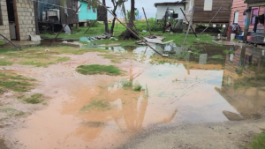
In the immediate area of the pumping station, residents were complaining that floodwater inundated their properties like never before. They questioned the effectiveness of the pumping station, while pointing out an accumulation of garbage in the canal.
Darwin Retreage
“We never does have this problem from when this mih build. Before this build water does run off quick. Less than half an hour. Since this build, this dah wah problem for this community around here. You go around and take a circle; you see a lot of flood people the flood out. You take a picture over there you will see how the garbage pile up, when this the stir up people the tek lick with the mud scent.”
Bernard Wagner
“Flooding is everywhere globally. If you look at Miami, our people need to appreciate that climate change is here and they have to play their role in keeping their yards clean of shrubs, ensuring the drain in front of their yards are clean. It is not just a city council task to take on drainage in front of residents. You should have that civic pride to take pride in your property to ensure that you aid in alleviating flooding in your neck of the woods. We will do our best, but you always require participation by the residents. This is not a one person activity. It requires participation, collaboration, everyone on board. It is not only Belize City, flooding occurs globally, all across the world.”
The rain certainly did not stop this week’s mas camp events. Several bands danced under the rainy night skies. They told us that their costumes are durable, and that rain can’t stop the Soca jam. Today, we also sought the opinion of Belize City residents on whether the carnival road march should be postponed. Here is a perspective from one carnival band leader and a resident we spoke with.
David Matus
David Matus, Band Leader, Titans Mas Camp
“As you can see we started off in the rain, because no rain cant stop this jam. So if you are worried about the weather, the weather is not going to stop us. Our customs are durable. You could use it every time, nothing will go wrong with it. So it is durability at its best.”
Kerry Sandoval
Kerry Sandoval, Belize City Resident
“Cho, I feel like deh have to cancel that. I am not into the carnival. I go to church and thing. I am not into the carnival. I not even care. But you cant have carnival on the tenth of September that is what I want to make them know, cause yeah we have to celebrate the tenth and twenty-first. After that year, they could have their carnival and dash out.”
According to the National Met Service, the central and northern areas of Belize received the most rain between nine p.m. on Thursday night and midday today. Belize City received over five inches of rain. The good news is that the showers have decreased. Scattered showers and isolated thunderstorms are expected over the next twelve to eight hours. But the good news is that a general decrease in showers is expected on Saturday.
Shanea Young
Shanea Young, Senior Climatologist, National Meteorological Service
“For the next eight to twelve a few showers, isolated thunderstorms and periods of rain, but mostly over coastal and northern areas tonight and tomorrow morning. And then during the course of the day tomorrow, a general decrease in showers is expected. We can still get up to about two to four inches of rainfall between now and tomorrow morning, and then conditions become a little less moist with showers decreasing over the area.”
Britney Gordon
“ As you mentioned, Belize City is experiencing the most rainfall, we can expect this to persist tomorrow as well? And if so, what areas specifically in Belize City?”
Shanea Young
“The rains and also the showers, Belize City is very small in the Belize District. So it’s the entire Belize District that got the most rainfall. But In terms of the showers, basically, especially the ones that have passed us, they cover the entire city. So both the north and the south side of the city has received around almost the same amount. Slightly less on the southern portions of the city with the areas near Port of Belize and the Coastal getting around one hundred sixty millimeters while on the north side. That was the area that got the 138 millimeters. And so tonight into tomorrow, there is no differentiation between which parts of the city should get at least light rain tonight into tomorrow. But like I mentioned after tomorrow morning, shower activity across the country, not just in the city, should start to decrease. As we go into the weekend.”
Britney Gordon
“So when you say tomorrow morning, around what time do you mean? Because as we know, we have activities very early on in the morning as well. So can we expect heavy rainfall during those as well?”
Shanea Young
“It’s still possible, but not as much. So by the afternoon, it should clear up. By, I would say maybe like by nine o’clock or so tomorrow morning, the significant shower activity should decrease.”
There is going to be a whole lot of rain, accompanied by thunder and lightning insome areas, as a strong tropical wave crosses over Belize starting tonight and for the next day. The weather system entered the Caribbean Sea earlier this week and moved in a northwesterly direction. Chief Meteorologist, Ronald Gordon told the media that Belize is not under any threat of a tropical cyclone watch or warning and that the system has not developed into a tropical depression or a tropical storm. According to Gordon, there is little to no chance of the system becoming anything more than a tropical wave before it gets here, but the amount of rainfall it is expected to produce is significant.
Ronald Gordon
Ronald Gordon, Chief Meteorologist
“In my calculation and based on the forecast models, the axis of this wave will cross the country early tomorrow morning, between midnight and six in the morning. However, the effects of the wave – the rainfall will begin affecting the country from late Thursday evening to tonight, intensifying throughout the night into tomorrow morning. Rainfall model projections are suggesting that for the first twenty-four hours, that is from about this evening into tomorrow evening, we can get up to two to four inches of rainfall with locally higher values from this tropical wave. As the system moves west of the country, we expect rainfall to decrease on Saturday to about one to two inches, then for Sunday, a further decrease. Apart from the very heavy rainfall, intense thunderstorm activity and lightning activity, we can expect it to become very gusty, especially during thunderstorms, leading to very rough sea conditions. So, certainly, apart from the excessive rainfall watch that we have in effect at the moment, which would likely be upgraded to an excessive rainfall warning by this evening, we will certainly issue a caution to mariners to be extremely careful out at sea because we do know that once you get this burst of activity during thunderstorms, you can have very strong winds and rough sea conditions.”
The approaching tropical wave is expected to cause flooding in some parts of the country, according to the Hydrology Department. The department has issued flood alerts for certain areas and has advised residents in flood prone locations to be on the alert for the possibility of flooding and to take necessary action. Chief Hydrologist, Tenielle Hendy updated reporters on areas where they already see rising waters.
Tenielle Hendy, Chief Hydrologist
“We do see the Sibun River reaching bank full stage, and we also are looking at the Mopan River, but based on our 24 hour outlook that we have, there is a caution out to residents in the south of the country, for them to monitor the water level in their area. As well as, you know, we might not be getting rainfall in our country, and it traverses our territorial boundaries. Just remain vigilant and look at the situation in terms of flash flooding. We are seeing some elevated levels in the northern or northeastern part of the country. In terms of the Maskall area, we’re seeing where there’s a lot of water channeling its way in that area, so we put out a flash flood alert and the alert means that flooding is possible to be prepared for the twenty-four-hour outlook. We’re looking at the Rio Hondo, Macall Rivers, all the rivers coming off the Eastern slopes of the Maya Mountains, we see those having elevated levels going into tomorrow morning.”
Because the tropical wave is expected to cause flooding and perhaps damage to older buildings, NEMO will have officers on standby and will be prepared to coordinate the rendering of assistance. NEMO Coordinator, Daniel Mendez also advised that because we are now entering the peak of the hurricane season, it’s important for everyone to have a hurricane plan.
Daniel Mendez
Daniel Mendez, Coordinator, NEMO
“We see the tropics have started to become active. So the time to plan is now you need to have your plan ready. You need to know what to do. So we will continue to stress that for the rest of the season. So, it is really important to have to be aware and to listen to all of the warnings and the briefings that are coming out from the med service and the hydrology. National Hydrology Service as well. Um, as I said, uh, NEMO is on, is on standby as, as, as normal. Uh, we will continue to monitor and be prepared to render any assistance as is required.”
Marion Ali
“The carnival related activities that are planned for tonight going into the weekend – what kind of advisory or advice would you give to these people who have already planned their events for this period of time?”
Ronald Gordon
Ronald Gordon, Chief Meteorologist
“The forecast is indicating that we will have excessive rainfall starting from tonight persisting tomorrow morning, and there’ll be a slight decrease later tomorrow into tomorrow night. However, early Saturday morning, in particular, the forecast indicates that we will have a lot of rainfall. I cannot say for certain if during the event or I don’t know, it will march, so to speak, to the beginning, but we do know that there will be moisture lingering behind waves. It will be west of us by then, and we see moisture lingering behind. So it is really up to the individual and to the, the person preparing these activities to take the necessary action that they would want to take but it will be raining. There is a potential for excessive rainfall tonight and tomorrow. It’s increasing on Saturday. So the good news for the activities on Saturday is that the rainfall will not be as heavy.”
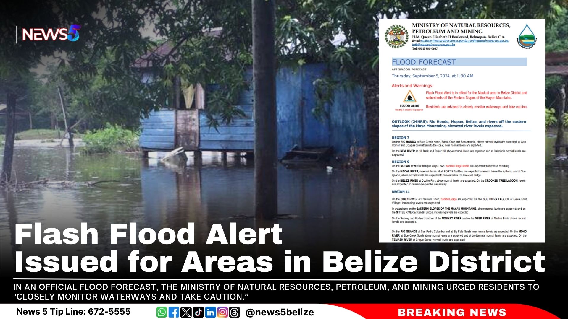
A Flash Flood Alert is now in effect for the Maskall area in Belize District and surrounding watersheds off the Eastern Slopes of the Mayan Mountains. In an official Flood Forecast, the Ministry of Natural Resources, Petroleum, and Mining urged residents to “closely monitor waterways and take caution.”
The Ministry’s Flood Forecast warns of elevated river levels over the next 24 hours. Above-normal levels are expected on the Rio Hondo at Blue Creek North, Santa Cruz, and San Antonio, with near-normal levels downstream at San Roman and Douglas.
Increased levels are expected on the Mopan River at Benque Viejo Town and above normal levels at San Ignacio on the Macal River, though below the low-level bridge. The Belize River at Double Run will have above-normal levels, while Crooked Tree Lagoon levels are expected to stay below the causeway.
The Sibun River at Freetown Sibun will experience bankfull stages and increasing levels on the Southern Lagoon at Gales Point Village. Watersheds on the Eastern Slopes of the Mayan Mountains and rivers like the Sittee, Monkey, and Deep Rivers will also see above-normal levels.
Above-normal levels are anticipated on the Sarstoon River.
Residents in these areas should stay alert for potential flooding.
The first week of Belize’s September festivities unveiled a tantalising preview of Saturday’s Carnival Road March, with Carnival Mas Bands showcasing just a taste of what’s to come. If you think you’ve seen it all, think again. This year’s carnival promises an explosion of vibrant colours, high-energy performances, and extravagant costumes.
However, attendees are advised to prepare for possible rain. Chief Meteorologist Ronald Gordon has reported that a tropical wave is expected to affect Belize. Although Gordon reassured the public that there are no tropical storm or hurricane warnings in effect, he warned of heavy rain and thunderstorms starting tonight: “There is a potential for excessive rainfall tonight and tomorrow. Decreasing on Saturday. So the good news for the activities on Saturday is that the rainfall will not be as heavy,” he stated.
So, hold on to your umbrellas for Belize’s annual carnival experience, rain or shine! Here’s a rundown of more activities for the coming weekend:
Belize City:
September 6: Street Fete at Marion Jones Sporting Complex, 9 PM – PAID
September 7: Carnival J’ouvert, starting at Belcan Bridge and winding through the principal streets of Belize City, 4 AM – FREE
September 7: Carnival Road March, beginning at Memorial Park, proceeding up Marine Parade, onto Barrack Road, then Princess Margaret Drive, and ending at Marion Jones Sporting Complex, 1 PM – FREE
September 8: 5th Martin’s Community Fest at Mahogany Street, 10 AM – FREE
September 8: National Day of Prayer and Ecumenical Service at Fordyce Chapel, SJC, 6 PM
Belmopan:
September 7: Food and Beer Fest at Independence Park, 5 PM
September 8: National Day of Prayer and Ecumenical Service at Independence Plaza, 9 AM
San Ignacio & Santa Elena:
September 6: Senior Citizen’s Day at Octavia Waight Centre, 11 AM
September 8: National Day of Prayer and Ecumenical Service
Benque Viejo:
September 8: National Day of Prayer and Ecumenical Service
Orange Walk:
September 8: National Day of Prayer and Ecumenical Service
Corozal:
September 8: National Day of Prayer and Ecumenical Service
San Pedro:
September 8: National Day of Prayer and Ecumenical Service
Dangriga:
September 8: National Day of Prayer and Ecumenical Service
Punta Gorda:
September 9: Fire Engine Parade through the principal streets of Punta Gorda, 7 PM
As carnival celebrations take place this weekend, the National Meteorological Service of Belize warns of mostly cloudy conditions with outbreaks of showers, thunderstorms, and periods of rain. An excessive rainfall watch is in effect, with potential impacts over the next few days.
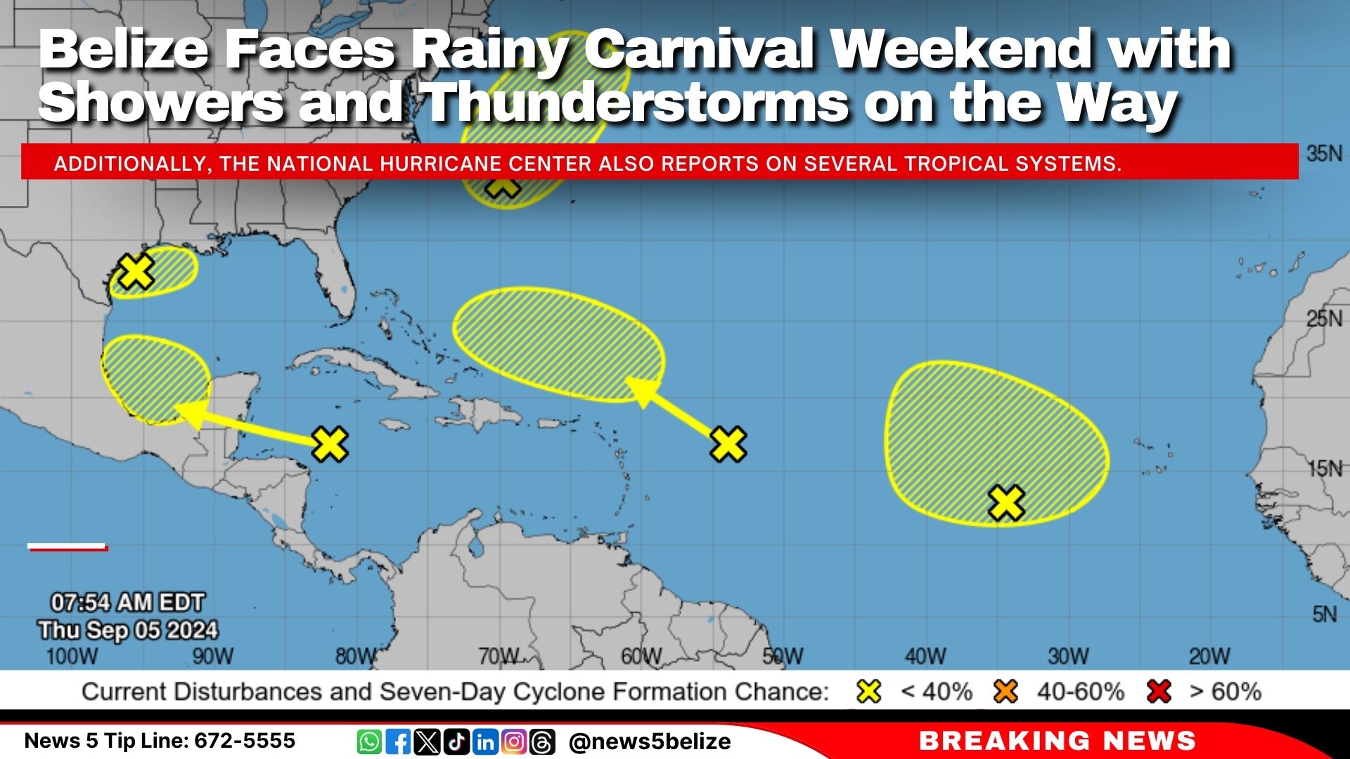
Additionally, the National Hurricane Center also reports on several tropical systems:
Northwest Gulf of Mexico: A trough is bringing widespread disorganised showers and thunderstorms. Heavy rainfall is anticipated along the northern Gulf Coast, with only a 10 percent chance of further development.
Northwestern Atlantic: A low-pressure system east of North Carolina could acquire subtropical characteristics. However, development is unlikely once it encounters cooler waters by late Saturday, with a 20 percent chance of further growth.
Eastern Tropical Atlantic: A broad low-pressure area is producing disorganised activity. Some slow development is possible as it drifts northwest, with a 10 percent chance through the next few days.
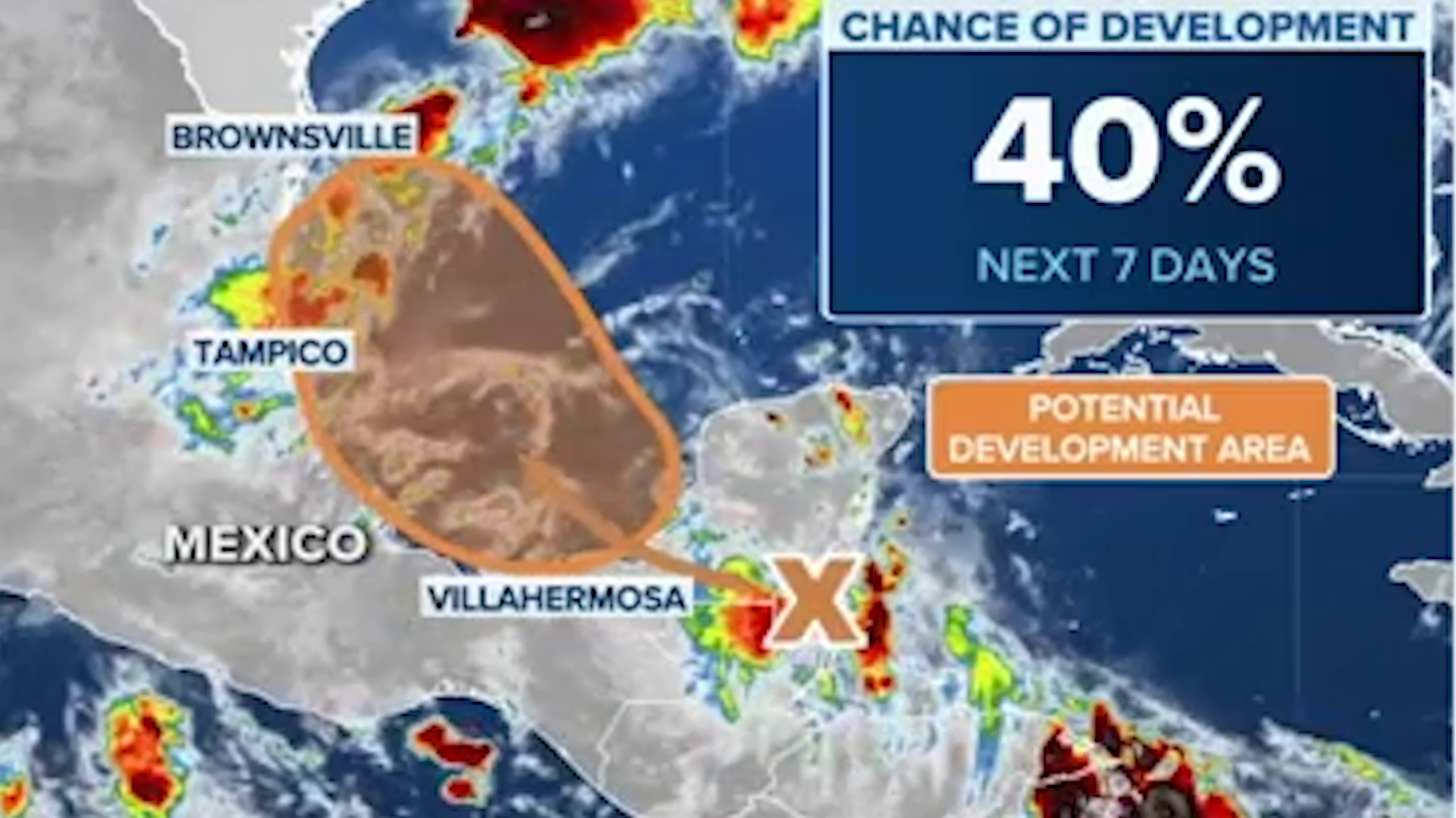
Western Caribbean Sea: A tropical wave is increasing shower and thunderstorm activity. While significant development is unlikely before reaching Belize and the Yucatan Peninsula, there is a 30 percent chance of development once it moves into the southwestern Gulf of Mexico.
The National Meteorological Service of Belize will be hosting a press conference this afternoon to provide updates.