Belize Faces Heavy Rainfall, Caribbean and Atlantic Monitored for Current Tropical Waves

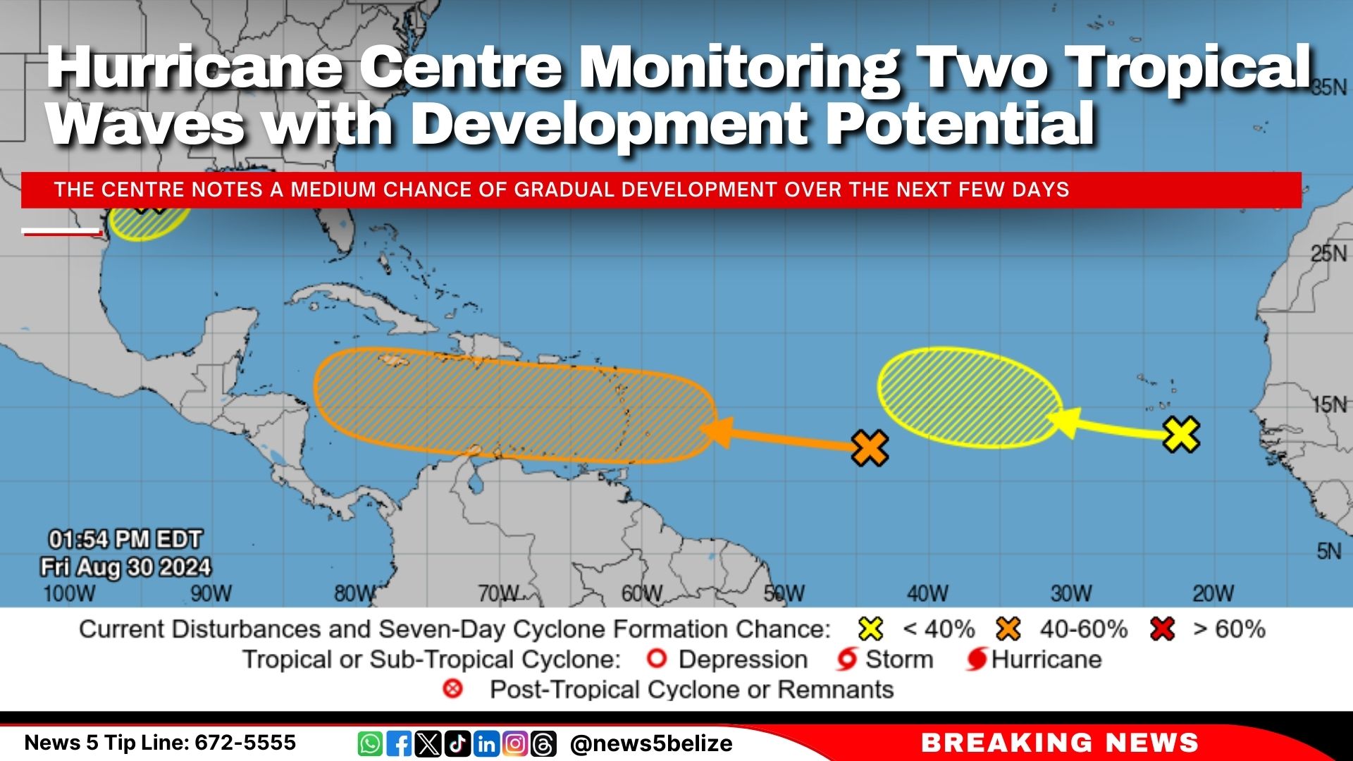
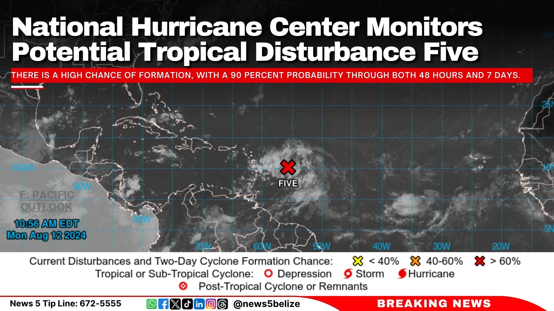
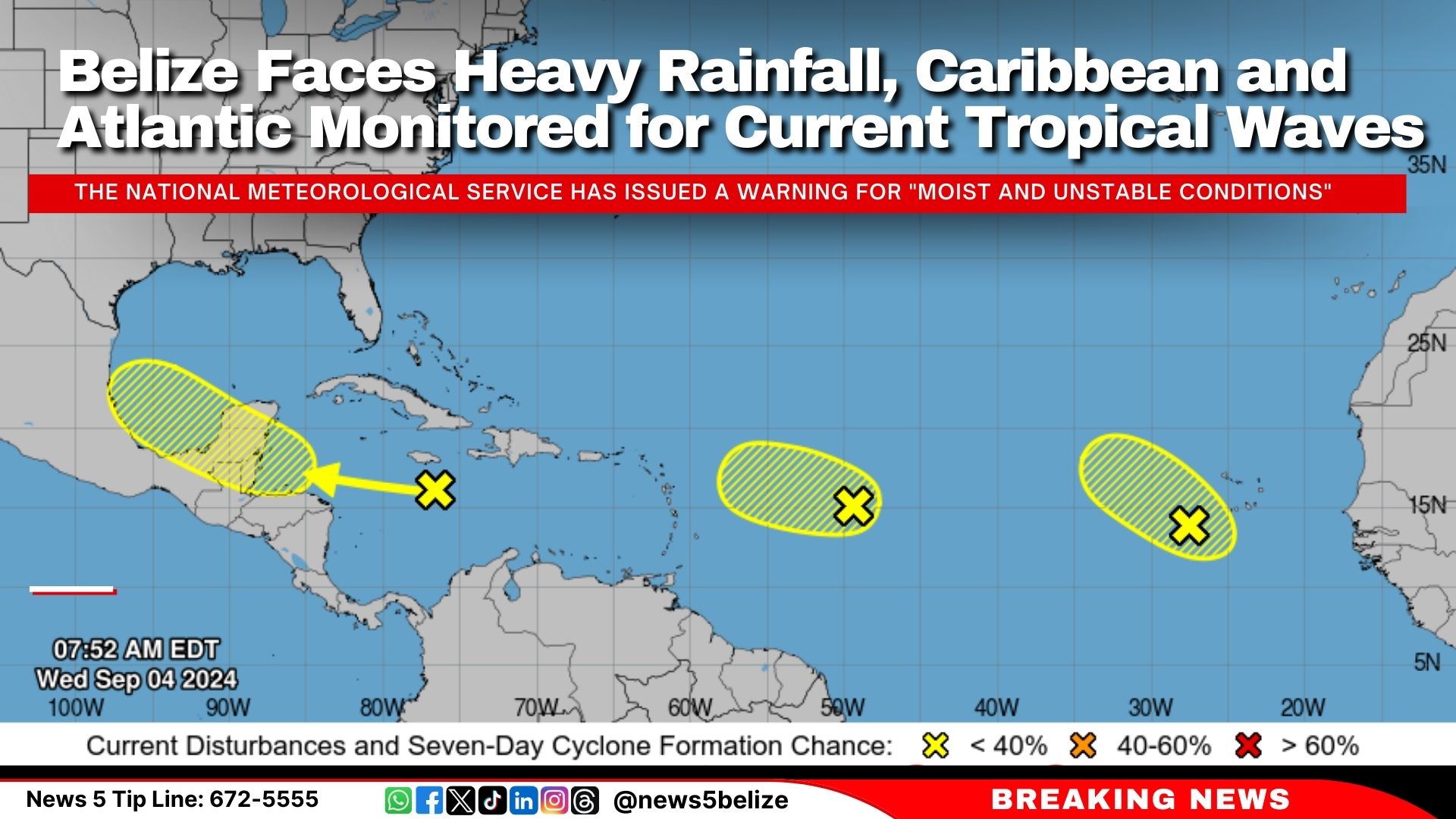
This morning, the National Hurricane Center in Miami reported several tropical waves with low chances of development. A tropical wave moving west at 20 mph is generating “disorganised showers and thunderstorms” near southeastern Cuba and Jamaica, with only a 30 percent chance of formation over the next week. Another wave, east of the Lesser Antilles, is showing minimal activity and has a 10 percent chance of significant development. A third wave in the eastern Atlantic is also producing disorganised showers, with a 20 percent chance of slow development in the coming week.

In Belize, the National Meteorological Service has issued a warning for “moist and unstable conditions” expected to continue over the next few days. The 24-hour forecast indicates “mostly cloudy to overcast skies,” with “a few showers, thunderstorms, and periods of rain” impacting northern and central areas today, with increased activity anticipated tonight, especially over the south and coast. 

An excessive rainfall watch is in effect due to the potential for heavy rainfall, and small craft operators are advised to exercise caution due to gusty winds and rough seas.

Hurricane Centre Monitoring Two Tropical Waves with Development Potential

The National Hurricane Center released its latest tropical weather update this afternoon, highlighting two systems under observation. The first, a tropical wave over the central tropical Atlantic, is associated with showers and thunderstorms but remains disorganised. The Centre notes a medium chance of gradual development over the next few days, with a potential to become a tropical depression next week as it moves westward across the Caribbean Sea. Currently, the formation chance through 48 hours is near 0 percent, but increases to 40 percent over the next seven days.

Additionally, another tropical wave near the Cabo Verde Islands is being monitored. Although it is producing minimal activity, some slow development is possible as it progresses west-northwest over the eastern and central tropical Atlantic. The formation chance through 48 hours is near 0 percent and rises to 20 percent through 7 days.

Atlantic Hurricane Season Entered Most Active Phase on Tuesday

The Atlantic hurricane season officially began on June 1, but on Tuesday, we entered the “season within the season”—the period when tropical activity in the Atlantic is at its most intense.

This peak period, which runs through October 10, includes the overall peak of hurricane season on September 10. Remarkably, two-thirds of all hurricanes occur during this time as activity surges.

This surge is fuelled by a combination of atmospheric conditions across a vast area of the Atlantic, including low wind shear, warm sea surface temperatures, increased moisture, and atmospheric instability. These factors come together most powerfully from August through mid-October, creating an ideal environment for the formation and intensification of tropical systems. September, in particular, is the most active month, with a large area of the Atlantic becoming a hotspot for development.

During this period, tropical waves emerging from Africa and moving into the Atlantic are often more organised and developed, increasing their chances of evolving into hurricanes.

While the likelihood of hurricane formation decreases after mid-October as atmospheric conditions become less favourable and potential formation areas shrink, the threat persists until the official end of the season on November 30.

Hurricane Ernesto to Impact East Coast and Bermuda This Weekend

Hurricane Ernesto is rapidly closing in on Bermuda as a Category 2 storm. Although Ernesto is showing signs of weakening this morning due to vertical wind shear, residents and officials are still preparing for severe weather. The National Hurricane Center (NHC) reported that as of 8 a.m. Friday, Ernesto was 255 miles south-southwest of Bermuda, with sustained winds of 100 mph. NHC maintains a hurricane warning is in effect for Bermuda, and they anticipate life-threatening flash flooding, especially in low-lying areas.

The Category 2 hurricane, which recently battered Puerto Rico and the Virgin Islands, left hundreds of thousands without power. In Puerto Rico, about 200,000 customers were still without power on Friday morning, reported CNN. The Virgin Islands reported over 10,000 customers without power.

As Ernesto continues its path, it is expected to move close to Atlantic Canada. Swells from Ernesto will affect the U.S. East Coast and other regions, including the Turks and Caicos, the Bahamas, Bermuda, and Atlantic Canada. Beachgoers should be cautious of dangerous surf and rip currents.

Hurricane Ernesto Heads Northward

The National Hurricane Centre (NHC) continues to monitor Hurricane Ernesto, currently situated about 500 miles south-southwest of Bermuda. Ernesto is moving north at 12 knots, with maximum sustained winds of 75 knots and gusts up to 90 knots. The storm’s minimum central pressure is estimated at 975 mb.

The NHC has indicated that no new tropical cyclone formation is expected in the North Atlantic, Caribbean Sea, or Gulf of Mexico over the next seven days.

In Belize, the 24-hour forecast predicts isolated showers or thunderstorms between Friday afternoon and Saturday midday. There may be a few more showers or storms over the southern regions on Friday night and Saturday morning.

Tropical Storm Ernesto Becomes Hurricane, Continues to Intensify

The National Hurricane Centre reported that Tropical Storm Ernesto has strengthened into a Category 1 hurricane. The storm is currently located approximately 175 miles northwest of San Juan, Puerto Rico, after passing over the Virgin Islands on Tuesday. Ernesto is moving northwest at 16 mph with maximum sustained winds of 75 mph.

The storm is expected to move into open Atlantic waters later today and could strengthen into a major hurricane. Forecasts suggest it could reach Category 3 status by the end of the week, with Bermuda potentially facing impacts.

In Belize, moist and unstable conditions will persist, but are expected to decrease over the next 24 to 48 hours. The forecast includes cloudy periods with a few showers and thunderstorms, gradually diminishing.

National Hurricane Center Monitors Potential Tropical Disturbance Five

The National Hurricane Center issues advisories on potential tropical cyclone Five. The disturbance is currently a few hundred miles east of the Lesser Antilles. 

There is a high chance of formation, with a 90 percent probability through both 48 hours and 7 days.

The next named storm for the 2024 Atlantic hurricane season will be Ernesto.

Tropical Weather Outlook: Potential System in Caribbean Sea

The National Hurricane Center reports that a tropical wave currently situated over the east-central Caribbean Sea is showing minimal changes this morning. The system is expected to progress westward across the central Caribbean Sea, with slow development anticipated over the next couple of days. Conditions for strengthening could become more favourable later in the week as the system approaches the western Caribbean Sea or southern Gulf of Mexico.

Currently, the likelihood of formation within the next 48 hours remains low at 10 percent. Over the next seven days, the chance increases slightly to 30 percent. The situation will continue to be monitored closely.

Caribbean Tropical Wave Shows Slow Development Potential as Debby Hits Florida’s Gulf Coast

The National Hurricane Center reports that Tropical Storm Debby made landfall as a Category 1 hurricane near Steinhatchee, Florida, early Monday, unleashing heavy rains and strong winds. 

In the Caribbean, a tropical wave near the Windward Islands is producing minimal activity. Development of this system is expected to be slow over the next few days as it progresses westward. However, conditions may become more favourable later in the week as it moves across the western Caribbean Sea or the southern Gulf of Mexico.

Formation chances for this system are low, with a 10 percent chance through 48 hours and a 30 percent chance over the next 7 days.

Tropical Weather Outlook: Potential Development Near Florida, Cuba, and the Bahamas

The NOAA reports that a well-defined tropical wave is currently causing scattered showers and thunderstorms across eastern Cuba, Hispaniola, the southeastern Bahamas, and Jamaica, along with adjacent waters. The system is expected to continue moving over Cuba today and enter the Straits of Florida by tonight or Saturday.

Environmental conditions are predicted to be favourable for further development, with a tropical depression likely forming this weekend over the Straits of Florida or eastern Gulf of Mexico. Tropical storm watches or warnings may be issued for parts of Florida later today.

Residents in Florida, Cuba, and the Bahamas are advised to monitor updates closely. A NOAA Hurricane Hunter aircraft is scheduled to investigate the system later today. Regardless of development, heavy rainfall is anticipated, which could lead to flash flooding in these areas.

Formation chance through 48 hours: 60 percent

Formation chance through 7 days: 90 percent

Exit mobile version