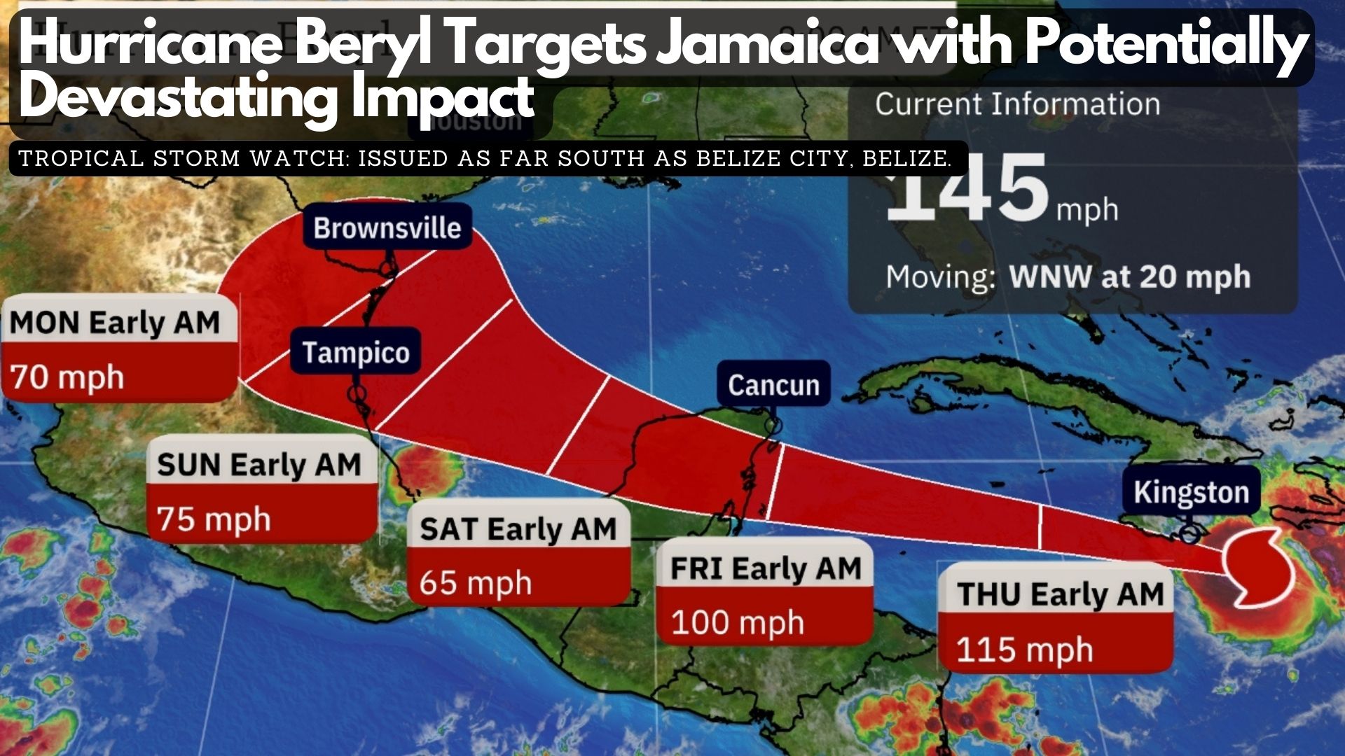
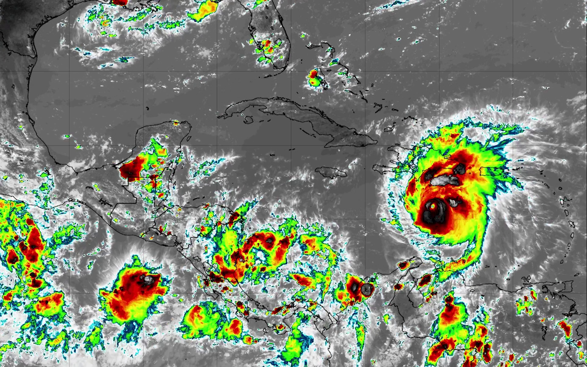
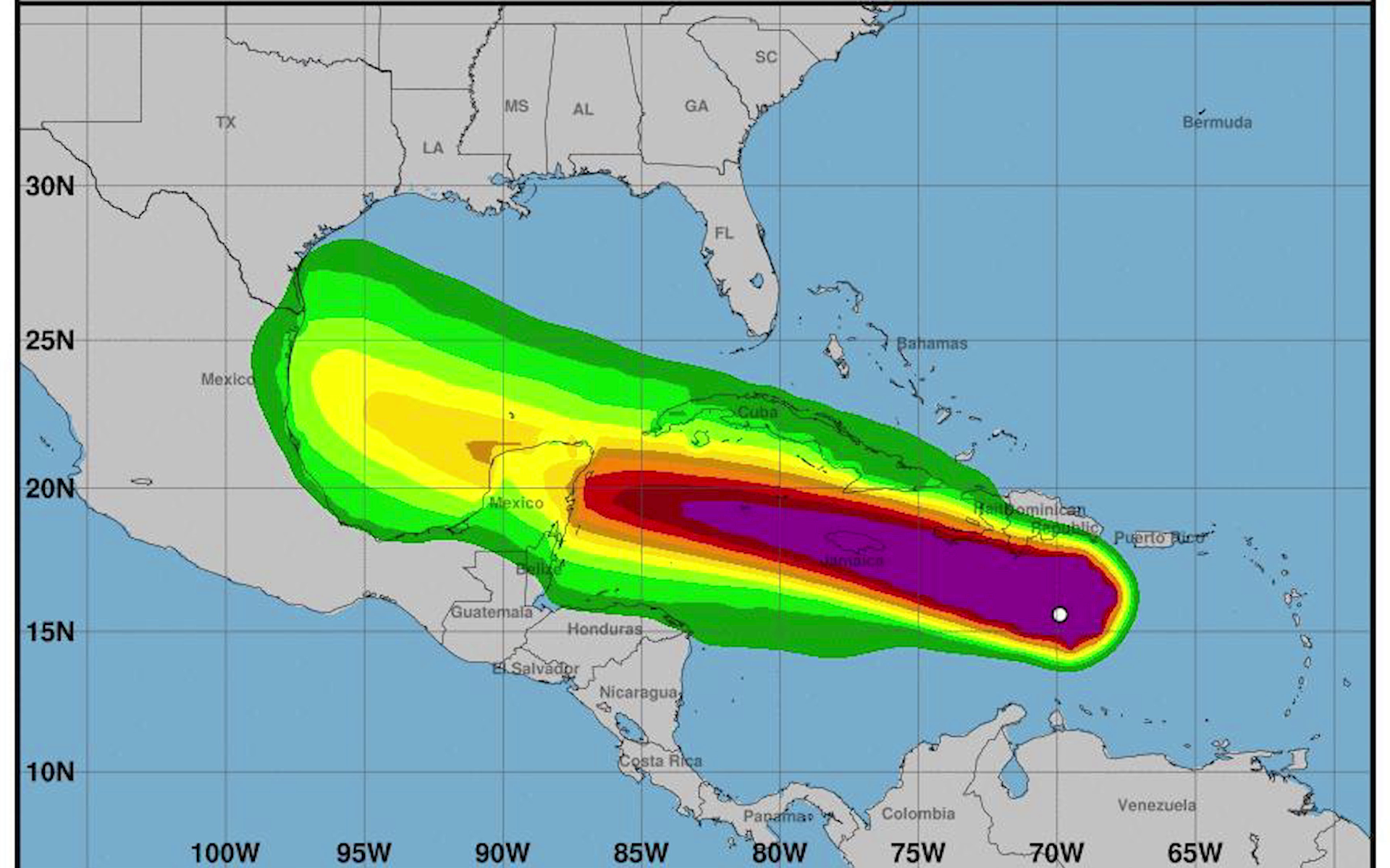
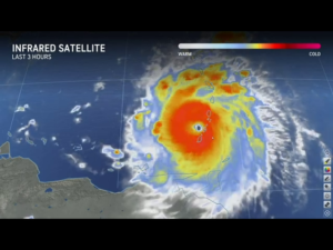
Current Status: Hurricane Beryl, a Category 4 storm, is rapidly advancing west-northwest in the northern Caribbean Sea, closing in on Jamaica. On Beryl’s eastern side, bands of heavy rain are impacting Haiti, raising concerns about potential flooding and mudslides.
Impact Forecast
– Jamaica: Beryl is expected to hit Jamaica on Wednesday with potentially devastating winds, particularly in mountainous regions, and a life-threatening storm surge reaching 6 to 9 feet above normal tide levels. Torrential rain could lead to flash flooding and landslides, marking the strongest hurricane strike on Jamaica since Hurricane Dean in 2007.
– Cayman Islands: On Wednesday night and Thursday, Beryl is forecasted to make its closest approach to the Cayman Islands, especially Grand Cayman, bringing storm surge flooding, high winds, and heavy rain. This could be the most significant hurricane impact on Grand Cayman since Hurricane Paloma in November 2008.
– Yucatan Peninsula: By Friday, Beryl is expected to make landfall as a hurricane on Mexico’s Yucatan Peninsula, affecting areas from the Belize border to Cozumel with storm surge flooding, damaging winds, and heavy rain.
Warnings and Watches:
– Hurricane Warning: Issued for Jamaica and the Cayman Islands.
– Hurricane Watch: Issued for the eastern coast of Mexico’s Yucatan Peninsula, including Costa Maya, Tulum, Cozumel, and Cancún.
– Tropical Storm Watch: Issued as far south as Belize City, Belize.
Areas under hurricane warnings are urged to complete preparations immediately. Those under hurricane watches should ensure their plans are ready to implement.
Hurricane Beryl became the earliest Atlantic Category 5 storm on record after impacting the Windward Islands on Monday. Beryl will continue its west-northwest trajectory through the Caribbean Sea this week. Although it will likely lose some intensity due to increasing wind shear, it remains a significant threat. The storm’s future in the Gulf of Mexico is uncertain, with potential impacts on eastern Mexico and Texas early next week.
Hurricane Beryl is now a category four hurricane as it barrels its way towards Jamaica where it is expected to make landfall into tomorrow. Earlier this morning, forecast models indicated a slight shift north in the storm’s projected path. Not much has changed with those projections throughout the course of today. As of six p.m., a tropical storm watch will be declared for Belize City all the way to Corozal. There is still a great deal of uncertainty as to where exactly Hurricane Beryl will make landfall, but it is expected to weaken and is already seeing decreased wind speeds. Hurricane Beryl will likely make landfall in the Yucatan Peninsula or Northern Belize as a category one hurricane. Chief Meteorologist Ronald Gordon gave us the latest this afternoon.
Ronald Gordon
Ronald Gordon, Chief Meteorologist, NMS
“The Hurricane continues to move rapidly west, north westward at twenty-two miles per hour and maximum sustained winds have decreased slightly. It is now a category four hurricane, a strong category four hurricane with maximum sustained winds of a hundred and fifty-five miles for hour. The latest satellite imagery I saw from Beryl is that the eye has become a bit more rapid, indicating that the system has been weaking due to the vertical wind shear and that is starting to affect the system. It would seem that the northern part of the country if it follows the most probable path will be the one on the fringes of tropical storm force winds. If it follows the worst case scenario and moves further south then of course hurricane force winds will affect that part of the country. The forecasted weakening indicates that at land fall it will be a category one hurricane. That is anywhere between seventy-four and ninety-five miles per hour, in terms of wind speeds and along with that we expect heavy rainfall near the center along with bands extending further out and of course storm surge to the north of the country which we don’t expect to impact the country of Belize.”
Daniel Mendez
Daniel Mendez, National Emergency Coordinator, NEMO
“We have been watching the system closely alongside the met service. WE have continued our preparations across the country. All the national committees met this morning to formulate a plane that we will implement across the country in case it is needed. At this time we remain on standby. All of our district committees remain on alter and will be prepared to mobilize in the next few days as we watch the development of Hurricane Beryl heading our way.”
National Emergency Coordinator, Daniel Mendez is urging the nation to continue its preparations. He noted that even if this system does not cause any severe impact to Belize, we are still at the start of the hurricane season, so those plans will not go to waste.
Daniel Mendez
Daniel Mendez, National Emergency Coordinator, NEMO
“In the meantime we continue to encourage the population to continue their preparations. It will not go to waste for sure. We also ask as you continue your preparations to reach out to those members of our community who are elderly, those with special needs and have some sort of disability, just check in to make sure their preparations are going well. Let us not forget them as we continue to work on this. NEMO will remain on standby throughout this period. The national Emergency Operation Center is in full operation and we will be monitoring this system for the next few days. We are on twenty-four seven watch along will all the coordinators across the country and we remain prepared to respond for anything. Our hotline is open, nine, three, six if you have anything to report or concern to share with us. We remain vigilant and we are prepared to respond as the storm gets closer.”
According to Chief Meteorologist Ronald Gordon, at least five models are in line with the current projections. This does not mean that the northern parts of Belize will not be impacted if the system makes land fall in Mexico.
Ronald Gordon
Ronald Gordon, Chief Meteorologist, NMS
“In terms of consistency we have seen that at least the last five models run from about three p.m. one that came out yesterday afternoon is showing this system will take this projected path and head towards Tulum on the Yucatan Peninsula. So I do reiterate that there is still a cone and a part of that cone still covers the extreme part of northern Belize, but it is a probability distribution and the highest probable path or the most likely probable path is at the center of that cone. We are confident enough in the forecast that we made the declaration at this point that we made the declaration. We have been communicating with the National Hurricane Center in Miami, the hurricane experts. We have shared what we are seeing and based on our mutual discussion we believe the system will make landfall north of the country. We know the system is not a point where I have always emphasized to media houses please don’t force me to say exactly where it will cross the shoreline there are impacts beyond that point. Therefore even if it makes landfall where it is projected to, we do know that the hurricane force winds and tropical storm force winds extend from that center. Based on that information we certainly communicate with Mr. Mendez and with the Prime Minister and we were allowed, approved to declare a tropical storm watch for the country.”
Residents and the business community of San Pedro have had numerous experiences with hurricanes threatening Belize over the past two decades. So, when the news emerged that Hurricane Beryl was heading in this general direction, the San Pedro Town Council wasted no time to mobilize and convene emergency management meetings. Even though Beryl has shifted course a bit and is now heading north of Belize, today, the town council met with the NEMO coordinator and the various departments. That meeting included the Coast Guard and even neighborhood watch groups to prepare themselves in the event Beryl changes course and jogs due west. News Five’s Marion Ali files a report on that meeting.
Marion Ali, Reporting
The San Pedro Town Council is wasting no time in taking precautionary measures ahead of Hurricane Beryl, if the storm changes course and heads directly our way. Today, Mayor Wally Nunez told News Five that they have been asking the residents to seek higher ground and they have taken heed to that advice.
Wally Nunez
Wally Nunez, Mayor, San Pedro
“One of the things that we are looking at as NEMO is having a count of how much people are leaving the island up to this morning at 10 a.m. We had roughly around 600 people who had left the island.”
There is that group of people, however, that perhaps, because of their youth, are not taking the threat of a hurricane seriously. Mayor Nunez offered some useful advice to them.
Wally Nunez
“It is not something just to take it lightly. A lot of people are just planning hurricane parties and people are planning because they’re going to be off from work. I think we need to take it a lot more serious. I know some people haven’t experienced a hurricane before, but it is quite dangerous and it could be catastrophic.”
The plane and water taxi services have also taken an early decision to call off normal trips to and from the island as of Wednesday.
Wally Nunez
“Caribbean Swinter had informed that they would be closing off midday tomorrow. And also, Tropic Air had a release that they would be operating up until, I think it was 11 or midday tomorrow as well. I don’t know if they will have an update on that based on what the trajectory of the storm is taking.”
With only two hurricane shelters in San Pedro, Mayor Nunez said that it is prudent that the residents have been moving off the island on their own., The shelters are primarily used for the neediest people.
Wally Nunez
“We only have two places for shelters, use the shelters. And they don’t carry a lot of about or quite the number of people in there. Compared to the amount of residents that here on the island so it is. It is for that same reason that we were asking for voluntary evacuation because, you I know that during a storm. We need to find a better location or a secret area areas where it’s higher. And even our shelters are not in the best location, but it’s what we have and what we can offer. So that’s for that same reason we were asking people to find another location probably in the mainland. But we have, the sagebrush. And the other one is, is a youth center from the Catholic Church, but the youth center from the church, we usually use it mostly for the disabled persons for the elderly.”
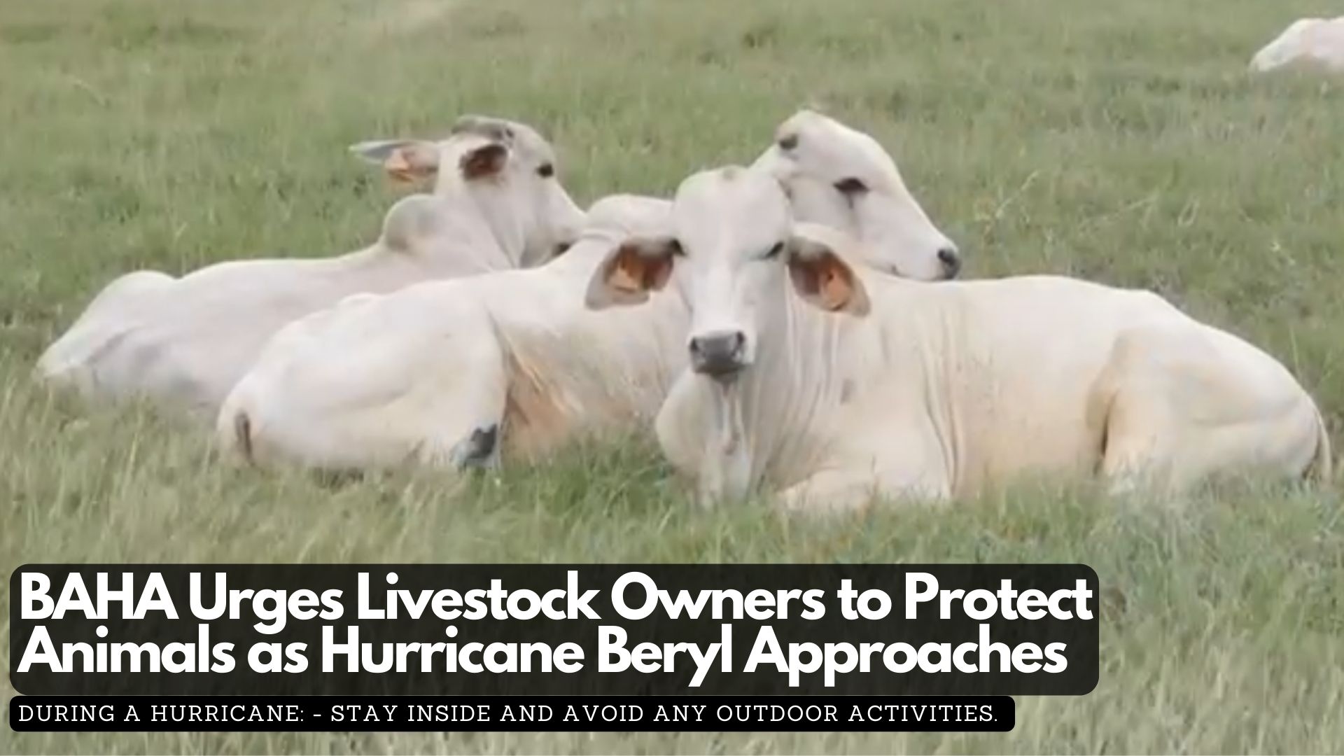
The Chief Veterinary Officer of the Belize Agricultural Health Authority (BAHA) is advising livestock owners to closely monitor the development of Hurricane Beryl and take necessary measures to safeguard both human and animal life. With an extremely active hurricane season forecasted, planning and preparation are crucial to minimize losses caused by such disasters.
BAHA recommends the following key activities to reduce the risk of harm to animals before, during, and after a storm:
Before a Hurricane:
– Ensure an accurate count of all animals owned or under care, with updated records and proof of ownership.
– Secure an adequate supply of feed, water, and veterinary supplies, including necessary medications for use before and after the storm.
– Move livestock out of flood-prone areas to higher, safer pastures.
– Secure animal housing and remove loose and dangerous items that could become projectiles during the storm, including feeders and waterers.
– Trim trees and remove branches that could potentially fall on barns or animal housing.
– Ensure pets have adequate shelter from the elements and are not tied down if proper shelter is unavailable.
During a Hurricane:
– Stay inside and avoid any outdoor activities.
After a Hurricane:
– Approach animals with caution due to potential stress caused by the storm.
– Conduct a complete headcount of all animals.
– Inspect animals for injuries or open wounds and provide immediate assistance.
– Ensure animals have access to clean water and food.
– Record and promptly dispose of any deceased animals.
– Evaluate and repair any structural damages to animal housing.
For further information, contact the Animal Health Department at animalhealth@baha.org.bz or call 824-4872.
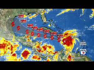
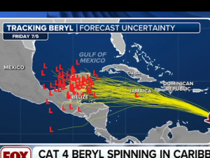
Tonight, Hurricane Beryl is barreling its way towards Central America. The tropical system developed into a hurricane over the weekend and rapidly intensified to a category four hurricane before making landfall in the eastern Caribbean. This is a historic tropical system as it is the first time a category four hurricane has developed within the Atlantic basin in the month of June. These types of weather systems are more common in the peak of the hurricane season, between August and October. Its projected path shows Belize and the Yucatan Peninsula inside the cone of impact. But it is too early for the experts to say whether Belize will experience a direct hit. Belize will however begin to experience the effects of the system as early as Thursday evening. Today, the National Emergency Management Organization hosted the first of a series of daily press conferences for this week. News Five’s Paul Lopez reports.
Ronald Gordon
Ronald Gordon, Chief Met Officer
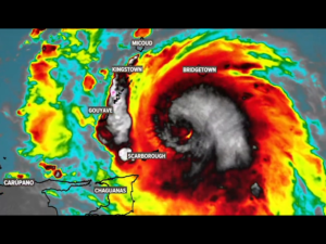
“Our update as of midday on a potentially catastrophic major hurricane Beryl was that it was moving west northwest at about twenty miles per hour away from Windward Island after having affected those island this morning. the projected forecast is for it to move to a west, northwest track towards the southeastern Caribbean Sea for the remainder of today, Tuesday, enter the central Caribbean Sea just around Jamaica on Wednesday and move into the northern Caribbean Sea on Thursday.”
Paul Lopez, Reporting
Beryl maintained its strength as a category four hurricane throughout the course of today, with wind speeds of up to one hundred and fifty miles per hour. Forecasts are calling for it to weaken as it enters the central Caribbean Sea.
Ronald Gordon
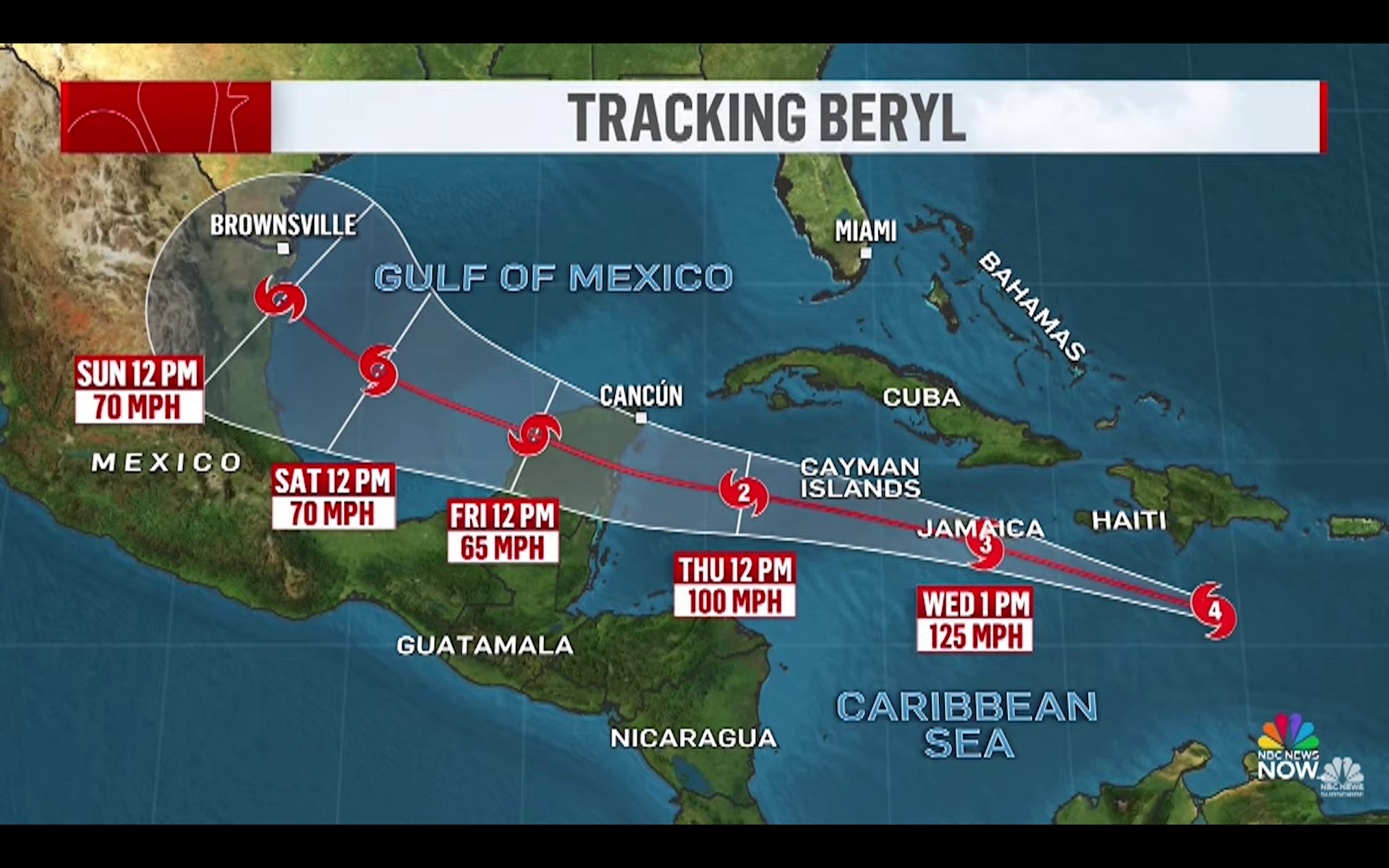
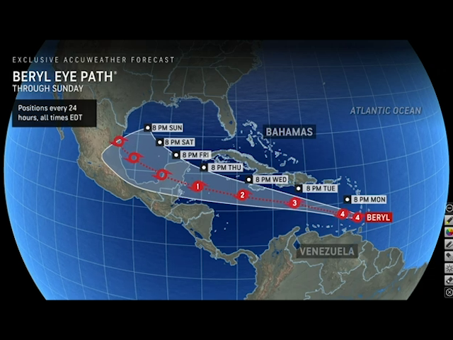
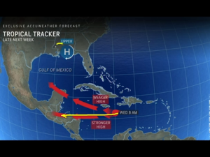
“In terms of the projected path, the system currently is moving west northwest. It will encounter a high-pressure ridge that will develop over the Gulf of Mexico forcing a more westward track. Just to make it simple for the public, a ridge is like a mountain, the hurricane cannot move over a mountain, so it moves around it. That ridge will block the system from moving north and push it on a westerly track after it leaves near Jamaica. There is still a lot of uncertainty. This is a four-to-five-day prediction. That carries a lot of uncertainty as you can see from the projected cone there is a hashed area near Belize indicating there is a high level of uncertainty where the system will be. However, the projected cone shows it anywhere from the southern district, let’s say Stann Creek to the Yucatan Peninsula.”
According to Gordon, the center of the hurricane can make landfall anywhere within the projected cone by Friday morning. There is also a great deal of uncertainty surrounding the strength that Hurricane Beryl will have when it makes landfall in the western Caribbean.
Ronald Gordon
“In terms of possible impacts we cannot say precisely at the moment given the uncertainty. But if the system moves within the projected path, we will likely receive some impact including strong winds and heavy rainfall which we will be able fine tune as the weeks goes on as we get more information.”
The National Emergency Management Organization will be activated as of nine a.m. on Tuesday morning. Daniel Mendez, the National Emergency Coordinator, is advising the country to prepare for the arrival of Hurricane Beryl on Friday.
Daniel Mendez
Daniel Mendez, National Emergency Coordinator, NEMO
“We continue to encourage the public to prepare. We highly encourage people who are living in low lying areas or areas that are flood prone to consider early evacuation to start moving in an advance as this develops. As the chief meteorologist has said, there is a large area of uncertainty, but we cannot wait until it is too late, so we encourage you to get these things done as soon as possible.”
The forecast track has shifted several times over the past twenty-four hours. According to Chief Meteorologist Ronald Gordon, it was moving further north from Belize. It then shifted south to include Belize. This is the uncertainty of the models that the experts are currently working with. One thing is certain, sea temperatures are above average for this time of the year. That is fuel for a tropical system.
Ronald Gordon
“The entire Atlantic and Caribbean basin are supercharged with hot water. So, we have looked at the figures. We are about two or three degrees Celsius above normal in terms of temperature. And like you said that is the energy these system needs to fuel them. That is precisely why this system intensified rapidly. This hurricane is the first category four hurricanes in history in recorded history for the month of June.”
Daniel Mendez
“Our message has been since June, May, you need to have a plan, start preparing and so while we cant tell you to go out an purchase, what we can tell you is to ensure you have a plan, you know where to go. Again, with this great degree of uncertainty for us to say yes you need to purchase these things and stock up, I think it would be too early to say. You must know what to do and where to, and you cannot wait until the last minute.”
So, when will the experts be able to confirm whether this system will make direct landfall on Belize? Gordon projects that by Tuesday afternoon there will be greater certainty about the path of the hurricane.
Daniel Mendez
“The best-case scenario is that it goes through the Yucatan channel and doesn’t affect anybody. That would be the best case. The worst case is that it comes direct to the country as a category two or three hurricane and that would be the worst-case scenario.”
As for the availability and readiness of hurricane shelters, National Emergency Management Coordinator, Daniel Mendez, says shelters have been inspected and are ready. Here is how he puts it.
Daniel Mendez
Daniel Mendez, National Emergency Coordinator, NEMO
“Yes, the shelter list is on our NEMO Facebook page or website. You can download it from there. The shelters we have inspected. You will find there is a category one, category two list. So depending on the intensity of this storm, we will be opening these shelters as necessary. So, through the district offices you will be provided with information as to which shelters will be open and when those will be open. Prepare your homes, if you need to seek shelter know where you are going. If you are living on the island, you know that this may impact you, start to live on your own. It can get very difficult if you wait until the last minute, you may not get space on a boat if evacuation is required. So, it is really important to take these steps now and early and keep in communication with the met service, NEMO, and use that information and take action.”
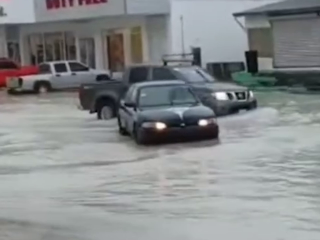
Over the weekend, several parts of Corozal District experienced severe flooding. The ground remains very saturated which is a cause for concern if Hurricane Beryl is expected to bring further rainfall. The fact that the country recently experienced a bout of severe drought may also lead to flooding in other parts of Belize. Tennielle Hendy, the Principal Hydrologist at the National Hydrological Services, explains.
Tennielle Hendy
Tennielle Hendy, Principal Hydrologist, National Hydrological Services
“The forecast for the north is still for flooding conditions to prevail. That is caused mainly by the excessive rainfall we received over the past couple of weeks. We are not seeing any riverine flooding which is different from precipitation related flooding. But there is the possibility that we do get riverine flooding from our neighbors, Guatemala and Mexico as we saw in Chetumal. The same time Chetumal was flooding, Belize in the north was also flooding but more recently the flooding we are seeing in San Roman, is based on excessive rainfall. That is called urban flooding. With any additional rainfall we can get, I would say with a minimum of six inches more we can see a combination of excessive rainfall coupled with riverine flooding. So you might be saying well you are using a lot of words what does this mean? It just means we will have flooding conditions for longer periods, because what we call localized flooding from excessive rainfall that runs into the river. but if the rivers are full where is it going to go? We also have to factor in tidal events. When the is a high tide the water remains stagnant or it starts to fan out or spread out and in areas that are not prone to flooding it becomes flooded. So there are a lot of factors we need to consider in terms of flooding that is why we work very closely with the met service and NEMO.”
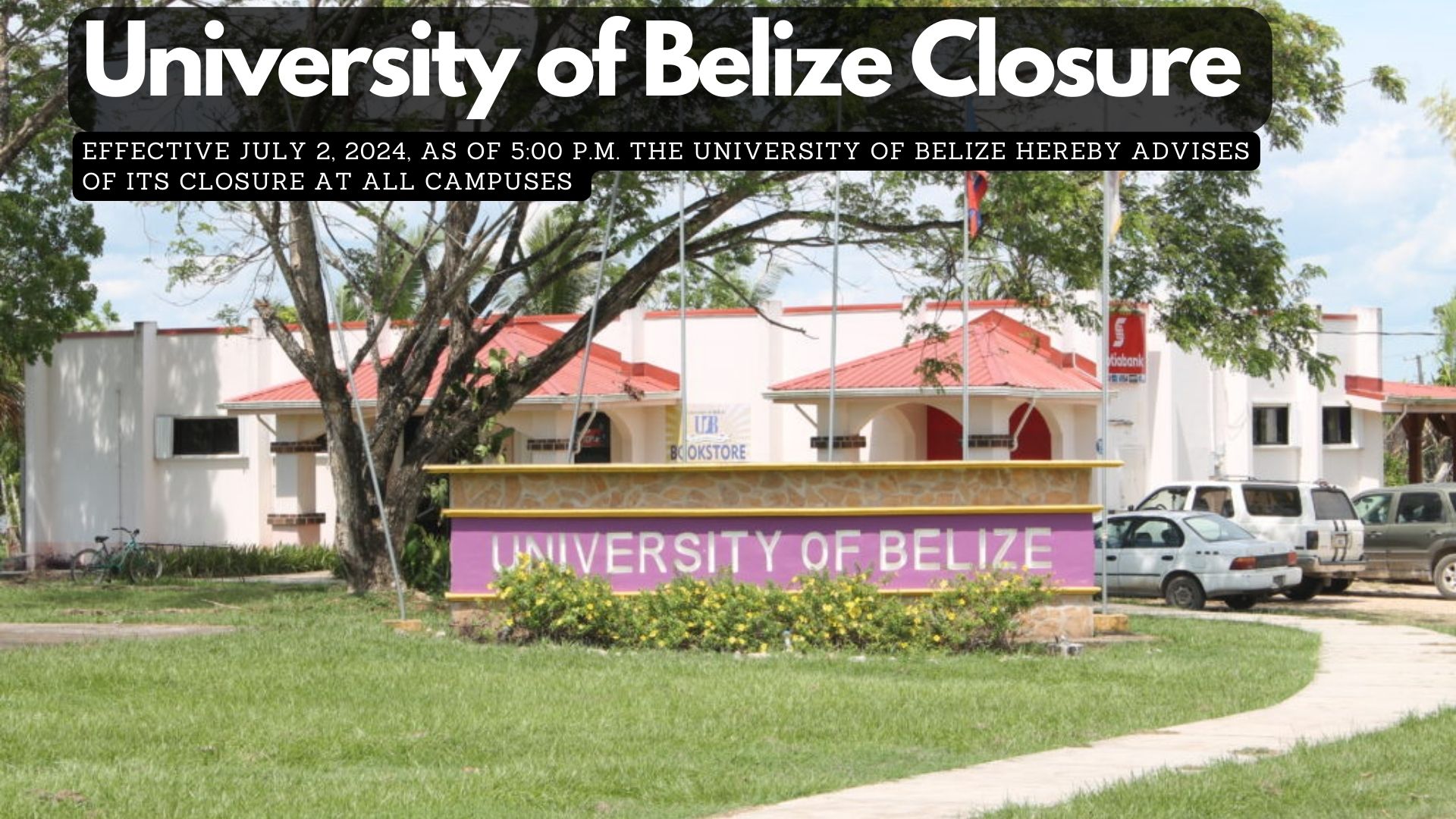
Effective July 2, 2024, as of 5:00 p.m. the University of Belize hereby advises of its closure at all campuses, due to the impending Hurricane Beryl. In this light, all summer classes will be canceled. Faculty members teaching summer classes are asked to upload all teaching materials to MOODLE. This preparation is in the event the University is unable to deliver face-to-face classes following the storm.
The University will keep you abreast of its reopening and asks everyone to keep safe and stay tuned to updates provided from official reports.