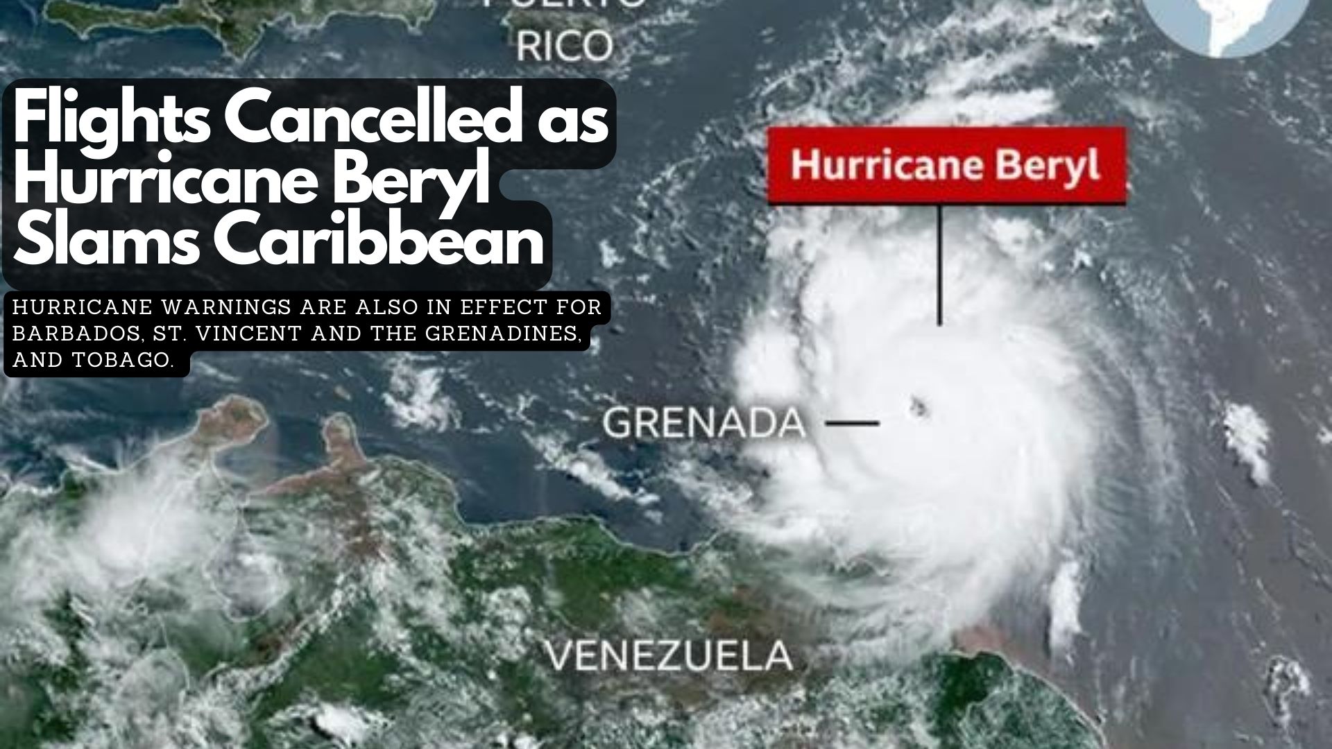
Hurricane Beryl has made landfall on Carriacou Island in Grenada. The hurricane, which has regained strength in recent hours, has prompted warnings of life-threatening winds and dangerous storm surges.
Hurricane warnings are also in effect for Barbados, St. Vincent and the Grenadines, and Tobago. Airports and businesses across the Caribbean have shut down, and residents have been urged to seek shelter as the potentially devastating storm hits the region. Dozens of flights were cancelled as Beryl approached on Sunday night, with leaders urging the public to heed warnings.
Beryl’s strength has been fluctuating. The hurricane was upgraded to a Category 4 on Monday after slightly weakening earlier.
Meteorologists say it is unusual for a hurricane of this strength to form this early in the year.
The US National Oceanic and Atmospheric Administration (NOAA) has warned that the North Atlantic could experience up to seven major hurricanes this year, up from the average of three in a season. It attributed record high sea surface temperatures as a contributing factor.
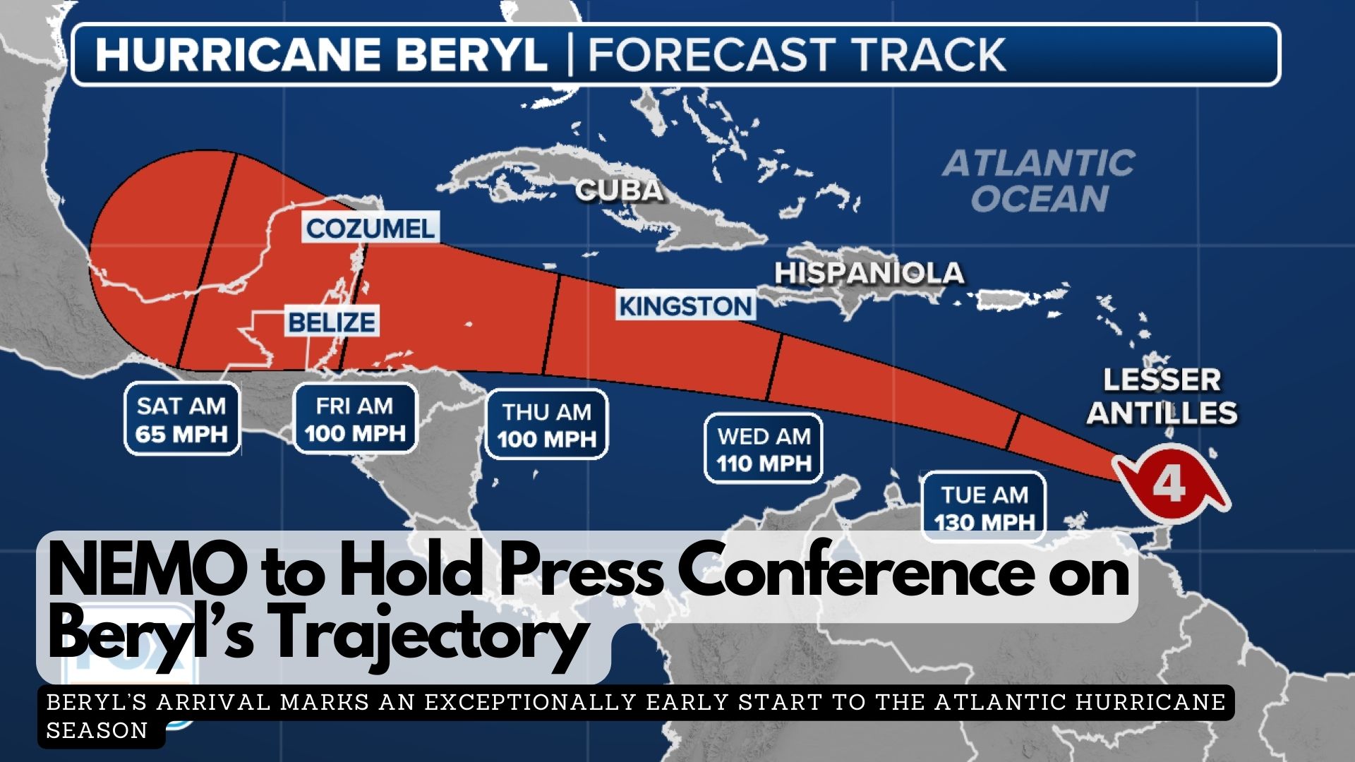
The Ministry of Blue Economy and Disaster Risk Management will hold a press conference today, July 1st, at 1:30 PM to provide an update on the trajectory of Hurricane Beryl in the Caribbean. The Belizean government is urging all citizens to continue their preparations without panic.
“Staying informed through official updates, having a plan, and remaining calm will help us all navigate any challenges that come our way.
Your safety is our top priority!”
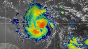
Hurricane Beryl is lashing the Windward Islands as life-threatening Category 4 in a dangerous early start to the season.
Early Monday, Barbados, Grenada, and Trinidad and Tobago began feeling the impact of Hurricane Beryl. St. Vincent, the Grenadines, and Grenada are most at risk of being struck by the storm’s core. While a direct landfall with the eye passing over the coast may not occur, Beryl will still deliver a devastating blow to the nearby islands.
Beryl’s arrival marks an exceptionally early start to the Atlantic hurricane season. On Sunday, it became the earliest Category 4 hurricane on record in the Atlantic Ocean and the only Category 4 hurricane ever recorded in June. The bathtub-warm ocean waters that fueled Beryl’s rapid intensification are a clear sign that this hurricane season will be far from normal, influenced by a warming world due to fossil fuel pollution.
Beryl is breaking records for June because the ocean is currently as warm as it typically would be at the peak of hurricane season, said Jim Kossin, a hurricane expert and science advisor at the nonprofit First Street Foundation.
The National Hurricane Center is now tracking Hurricane Beryl, currently less than 1,000 miles east of the Caribbean.
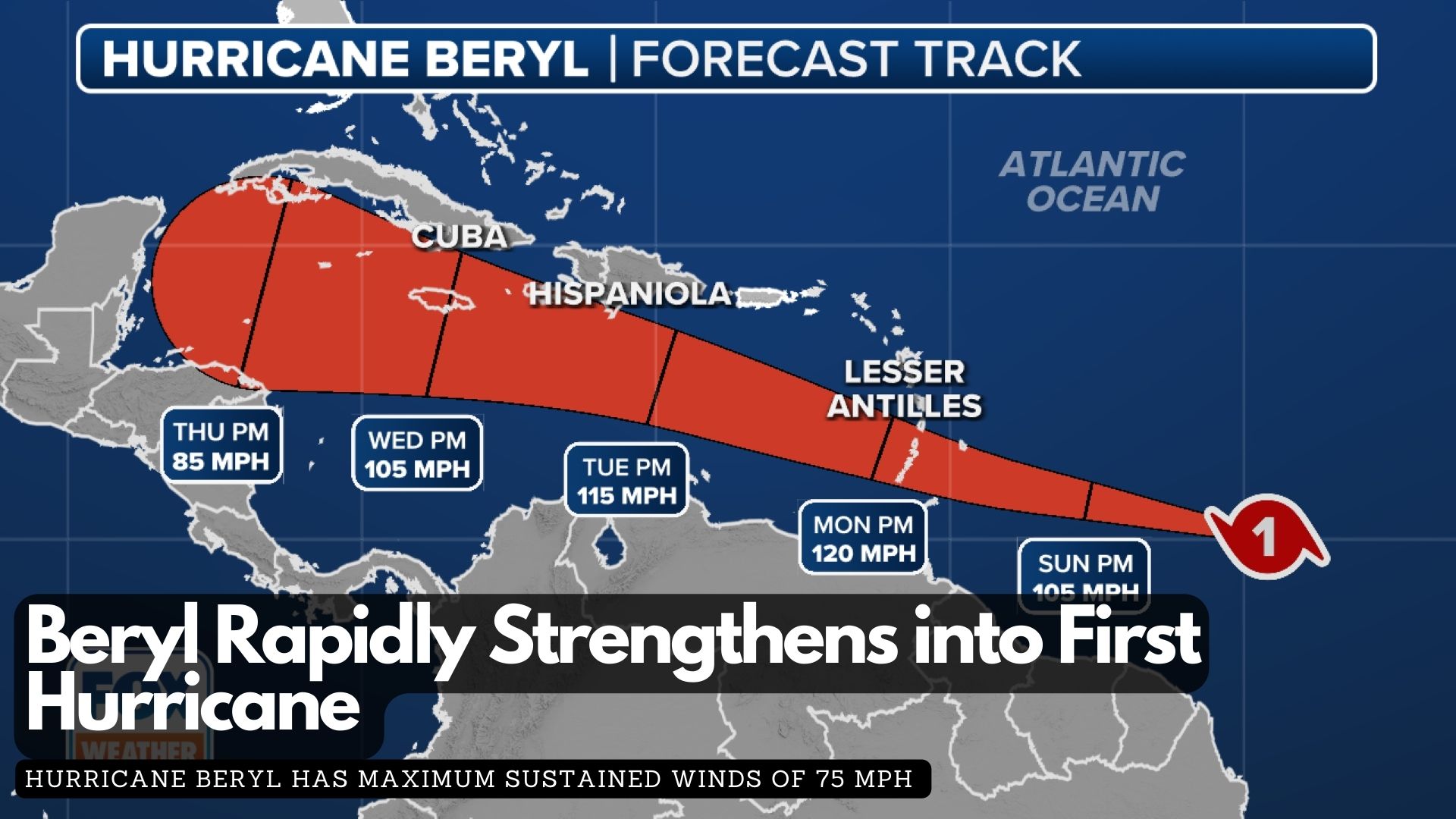
The second named storm of the 2024 Atlantic hurricane season rapidly intensified from a tropical depression to a tropical storm and then to a hurricane within 24 hours, aided by favorable atmospheric conditions.
According to the latest report from the National Hurricane Center, Hurricane Beryl has maximum sustained winds of 75 mph and a minimum central pressure below 992 MB, classifying it as a Category 1 hurricane on the Saffir-Simpson Hurricane Wind Scale. This early season hurricane formation is unusual, as the average date for the first hurricane in the Atlantic basin is August 11.
Water temperatures in parts of the central Atlantic are more typical of August and September, and Beryl’s small size has allowed it to avoid Saharan dust and adverse upper-level winds.
A Hurricane Warning is in effect for Barbados, while other nearby islands, including St. Lucia, Grenada, St. Vincent and the Grenadine Islands, Martinique, Dominica, and Tobago, are under watches.
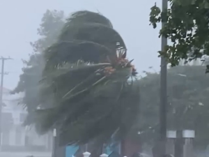
Damaging winds, both tropical-storm-force and hurricane-force, extend up to 45 miles from the center. On its current trajectory, Beryl will impact the Windward Islands with damaging wind gusts over the next 72 hours as it moves west or west-northwest.
The latest forecast from the NHC indicates that winds could reach up to 120 mph in the eastern Caribbean, potentially upgrading Beryl to a major Category 3 hurricane. In addition to hurricane-force winds, the storm is expected to bring torrential rains, with forecast totals of 3-6 inches across Barbados and the affected Windward Islands, likely causing localised flooding.
The NHC has also upgraded its storm surge forecast, now predicting a “life-threatening” surge that could raise water levels by 5 to 7 feet above normal tide levels in areas of onshore flow.
As Barbados braces for severe weather in the next 48 hours, Prime Minister Mia Amor Mottley is urging Barbadians to stay prepared and vigilant as the country braces for Beryl’s impact.
In a video statement tonight, the Prime Minister mentioned meeting with various government departments and agencies earlier today to ensure readiness for any eventualities. She also encouraged Barbadians to look out for each other within their communities.
The Barbados Meteorological Services has issued a Hurricane Watch for Barbados, as Tropical Storm Beryl is anticipated to strengthen into a hurricane before reaching the island late Sunday night.
Residents should prepare for strong winds that could damage homes and properties, along with potential flash flooding, especially in flood-prone areas. Severe thunderstorms may also disrupt power and utility services.
Marine conditions are expected to worsen, with a small craft and high surf warning already in effect due to above-normal sea swells anticipated from Sunday night.
The public is advised to follow guidance from the Department of Emergency Management and local officials. Stay informed through the Barbados Meteorological Services, Department of Emergency Management, and Government Information Service websites, as well as their social media channels and local media.
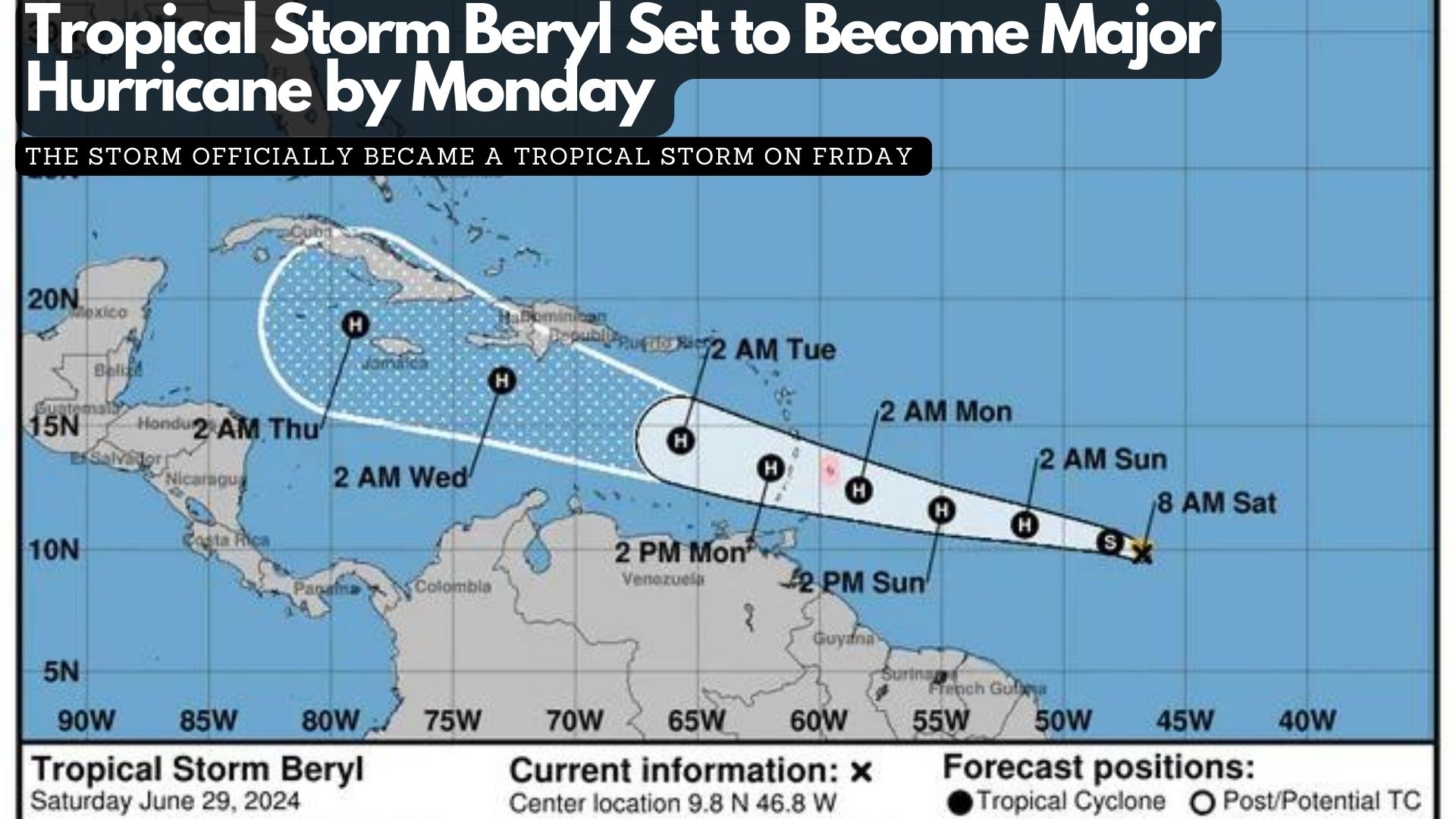
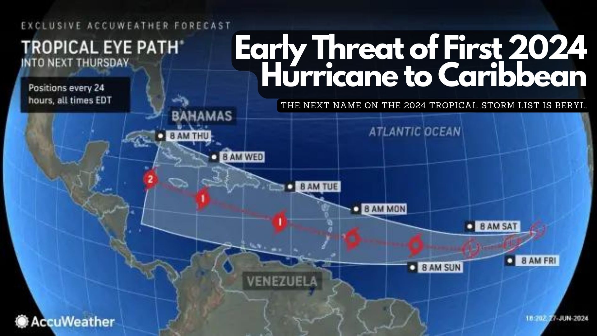
Tropical Storm Beryl formed Friday evening in the Atlantic, east of the Windward Islands, and is projected to become a “dangerous major” hurricane by Monday, according to the National Hurricane Center.
As the second named storm of the 2024 Atlantic hurricane season, Beryl is anticipated to reach hurricane status by Saturday night or Sunday morning as it moves westward. The storm officially became a tropical storm on Friday, approximately 1,100 miles southeast of the Windward Islands at the eastern end of the Caribbean.
As of the hurricane center’s 11 a.m. advisory on Saturday, Beryl was moving at about 23 mph, with maximum sustained winds of 65 mph. The center predicts that Beryl will strengthen into a hurricane by late Saturday or early Sunday and continue to intensify, reaching major hurricane status with winds of 111 mph or more before its center reaches the Windward Islands on Monday morning. The atmosphere and ocean conditions along Beryl’s path are described as “abnormally favorable for strengthening.”
However, conditions may become less favorable after the storm enters the Caribbean, where it could encounter disruptive winds that might prevent further strengthening, the center noted this morning.
Tropical Storm Beryl on NOAA Satellite on Saturday morning.
Beryl is currently 820 miles east-southeast of Barbados, and tropical storm-force winds are expected to extend 45 miles outward from the center. The storm could bring heavy rain, hurricane-force winds, and dangerous storm surges and waves as it crosses the Windward Islands on Sunday night into Monday. A hurricane watch has been issued for Barbados, and more watches are expected later Saturday as the system moves further into the Lesser Antilles, which include the Windward Islands, Leeward Islands, and Leeward Antilles.
Barbados and nearby islands could receive 3 to 6 inches of rain, with localized flooding in vulnerable areas and life-threatening surf and rip currents. People in the central and western Caribbean should monitor the storm’s progress, keeping in mind that the forecast’s margin of error can be significant four or five days out.
By Sunday evening, as Beryl moves into the Caribbean Sea, it could have winds up to 105 mph. Although atmospheric conditions in June are typically not conducive to storm strengthening, some computer models are “quite aggressive” and suggest that Beryl could be a major hurricane before reaching the Windward Islands. Once the storm enters the Caribbean, forecast models are not yet in agreement on its potential path. For now, the official forecast cone shows that the hurricane’s center could be near or over the western half of the Dominican Republic and Haiti on Tuesday evening and over Jamaica or eastern Cuba on Wednesday evening.
Nearly one month into hurricane season, the Ministry of Disaster Risk Management, NEMO, and the National Meteorological Service are evaluating Belize’s plan for the ongoing season. Day two of the twelfth National Climate Outlook Forum got underway in Belize city this morning, where several organizations discussed the strategies that will be implemented moving forward. News Five’s Britney Gordon attended today’s event to learn how prepared Belize is for the 2024 hurricane season. Here’s more on that.
Britney Gordon, Reporting
In 2023, Belize was spared from all the seven hurricanes that tore through the Atlantic during the fourth most active hurricane season since 1993. Nonetheless, Hurricane Lisa, a category one storm that made landfall in 2022, devastated Belize, leaving in its wake hundreds of millions of dollars in structural damage and economic losses. So, is Belize prepared for another Hurricane? That is the question that key stakeholders are seeking to answer at the twelfth National Climate Outlook Forum. Daniel Mendez, coordinator of NEMO, explains.
Daniel Mendez
Daniel Mendez, Coordinator, NEMO
“We are in the middle of the hurricane season. So by now, everyone should have had a plan already. You should know where to go, what you’re going to do if there’s ever a storm developing in our area. So what we’re doing with the MET service today is really to understand the outlook for this season for us at NEMO. We need that for planning purposes. So we can know where to go, what to do, and how we’re better guided in our work. But like I said, in the hurricane season we at government, have a plan, and we also want to ensure that every sector, every organization, every home, every person has also a plan on knowing what to do if there’s ever that in our area.”
The intensification of dry and wet season is a direct result of climate change. Chief Meteorologist Ronald Gordon says that extended dry seasons are becoming a more common occurrence.
Ronald Gordon
Ronald Gordon, Chief Meteorologist, National Meteorological Service
“What we’re seeing is that gradually our dry season is becoming more intense as we saw recently with wildfires and the extreme dry temperatures that we had. We also noticed that sometimes at the start of rainy season, we get rains, but then eventually we get an extended what we typically used to call the maaga season. That’s between around July to August. Sometimes we get an intense dry spell as well. So we noticed that there are changes occurring. And of course, we know that our temperatures are increasing. As we look at our data every year, we monitor our temperatures, they are going up. So It is quite clear that we are in the area of climate change and temperatures are increasing.”
The Ministry of Disaster Risk Management’s preparation includes engaging all partners in information sharing, planning, response and recovery strategies.
Kennedy Carillo
Kennedy Carillo, C.E.O., Disaster Risk Management
“Many times we feel that NEMO is just one organization responsible. But in reality, NEMO is a system, it’s a national system that includes governmental, non-governmental and we have a lot of partners in the private sector community. Everybody, even you, at your home. You are part of Nemo.”
Carillo further explains that the Met Service plays a key role in ensuring that Belizeans are informed and prepared. Stakeholder engagement in this conversation is vital.
Kennedy Carillo
“The Met Service engages a group of technical experts who on a regular basis are being trained. They’re identifying areas, new areas for to be trained. They’re also improving in terms of their technology. And so I think that our country can really feel proud. That we have a met one of the best met service in the region so much so that countries in the Caribbean and even in the US depend on us for information, and I think this is what we’re getting from these forums. The opportunity to recognize where there are areas for improvement.”
The outcome of Belize’s 2024 Hurricane season is yet to be determined, however, Mendez assures the public that NEMO and its partners are doing their part to ensure that Belize is as prepared for the season as possible.
Daniel Mendez
“We are doing our best to strengthen our systems. We have been doing a lot of revision of our plans. We know that we have to strengthen our plans, and we also have to be better understanding the increased hazards, the increased capacity of these hazards to cause damage. So we are in the middle of a review of all our plans and strengthening those, not only within NEMO, but also within all our partner committees. Also with the different villages and municipalities in the country.”
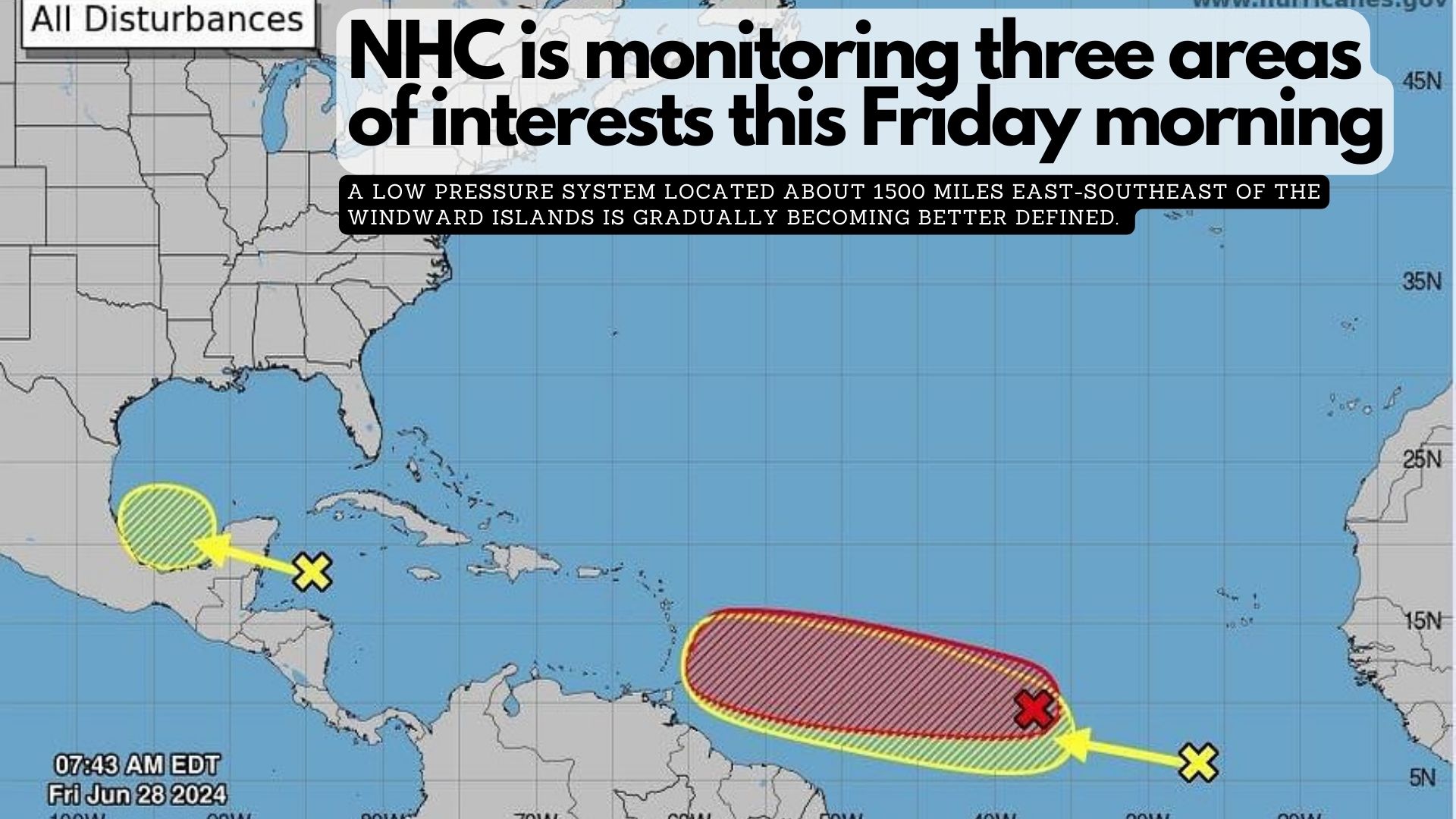
1. Western Caribbean/Southwestern Gulf of Mexico (AL94): A broad area of low pressure over the western Caribbean Sea associated with a tropical wave continues to produce widespread shower and thunderstorm activity. Development of this system is not expected today while it moves west-northwestward at around 15 mph, and an Air Force reconnaissance mission planned for today has been canceled. The disturbance is then expected to move westward over the Yucatan Peninsula and emerge over the Bay of Campeche late Saturday or early Sunday, at which point some development will be possible. Regardless of development, heavy rainfall associated with the tropical wave will affect portions of Central America and Mexico through the weekend. It has a low (30 percent) chance of formation in the next 48 hours and in the next 7 days.
2. Central Tropical Atlantic (AL95):
A low pressure system located about 1500 miles east-southeast of the Windward Islands is gradually becoming better defined. Showers and thunderstorms are also showing signs of organization, and a tropical depression or tropical storm will likely form later today or on Saturday. This system is expected to move westward at 15 to 20 mph and approach the Lesser Antilles by the end of the weekend. Interests there should monitor the progress of this system. For more information, including gale warnings, see High Seas Forecasts issued by the National Weather Service. It has a high (90 percent) chance of formation in the next 48 hours and in the next 7 days.
3. Eastern Tropical Atlantic:
A tropical wave centered several hundred miles south-southwest of the Cabo Verde Islands is producing disorganized showers and thunderstorms. Some slow development of this system is possible next week while it moves generally westward across the central and western tropical Atlantic at 15 to 20 mph. It has a near zero chance of formation in the next 48 hours and a low (20 percent) chance in the next 7 days
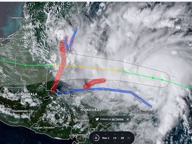
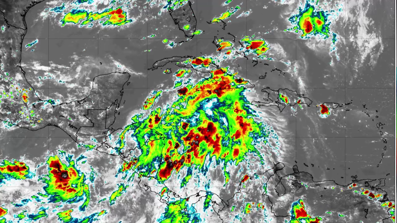
A weather system that will cross this region over the weekend is expected to dump major rains over Belize. Chief Meteorologist Ronald Gordon says the system has little chances of developing into a hurricane before it reaches, but that we need to be alert and take necessary action if our area is prone to flooding. In addition to that, another weather system further out will likely become a hurricane and could possibly come near to us.
Ronald Gordon
Ronald Gordon, Chief Meteorologist
“We are looking at two systems currently that are in the area where one is just on our doorstep just northeast of Honduras, and that’s a broad area of low pressure that currently has a low chance of development before it approaches our coastline. That system will affect us starting tonight. We are going to see an increase in rainfall, and that will persist at least through to Saturday or Sunday of this week. So we’re looking at a few days of relatively heavy rainfall across the country from this system. As I mentioned previously, the chances of it becoming a tropical depression or a hurricane before it gets here are quite low. But it’s going to be a rain producer. And then the second system we’re looking at is more out there in the Atlantic. It’s midway between Africa and the Lesser Antilles and that system has a higher chance of becoming a tropical cyclone within about 48 to 72 hours. We are looking at several models. One of them indicates that system will likely affect the Lesser Antilles on Monday of next week and then enter the Caribbean Sea and thereafter there are some divergence of where it is going. One model shows it going just over northern Honduras. One takes it further to the north. We’re in hurricane season. We know we need to be prepared. So what residents should be doing right now is to closely monitor the weather situation, stay tuned to official weather forecasts and certainly be prepared in the event that we need to take any action.”
The various city, town and village councils have held their hurricane preparedness training sessions and meetings for the 2024 Atlantic Hurricane Season. Today, the Ministry of Blue Economy held its first ever such forum and it had in attendance a host of government departments and units. News Five stopped in at the event in Belmopan and spoke with C.E.O. in the Ministry of Disaster Risk Management, Kennedy Carrillo, and NEMO Coordinator, Daniel Mendez. They said people have to change their mentality that NEMO is just an organization; instead, they say we all have a role to play in NEMO.
Kennedy Carrillo
Kennedy Carrillo, C.E.O., Min. of Blue Economy
“The National Emergency Management Organization and Disaster Risk Management Ministry overall is now under the responsibility of a new minister, a new C.E.O., and obviously our approach to the response at a national level will come with innovation and it will come with greater inclusion. These are some of the areas that we have already assessed as areas that can be strengthened. And so as a ministry, we had very quickly and very fast the opportunity to assess how prepared are we to respond to disasters just three weeks into assuming responsibility for the ministry because of the unprecedented and forest fires and so it was baptism literally by fire, but it gave us the opportunity to assess and to look at where the weaknesses are, and one of them is engagement, at a national level, engagement of the key partners that play an important role in emergency response.”
Daniel Mendez
Daniel Mendez, Coordinator, NEMO
“We’re discussing many different issues that are important to the whole disaster management function. This is where we’re trying to steer NEMO. So we’re moving away from the being name of being the response only organization to one that really focuses on all aspects of the disaster management cycle, including recovery. And these are issues that we haven’t really been speaking about. So the forum today really gives us that ability to reach out and to spend more time talking about these. What we will do for NEMO as C.E.O. Kennedy has said, is really to strengthen the system, the NEMO system, which is important. NEMO is not just the organization that you see on the ground with the people in NEMO uniforms, but actually all of government, everyone is part of NEMO during a disaster.”
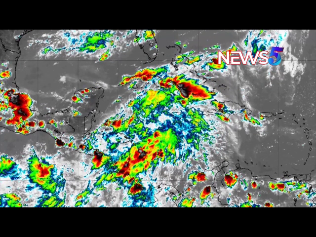
AccuWeather is reporting that early activity in the tropical Atlantic suggests the potential formation of a tropical storm or hurricane, posing a threat to the Caribbean. A narrow plume of moisture extending from the south-central Atlantic to the Caribbean Sea could aid in the system’s development and intensification.
AccuWeather began labeling this system as a tropical rainstorm on Thursday to heighten awareness of its potential hazards to life and property.
Forecasters anticipate the system to strengthen to at least tropical storm intensity as it nears the Windward Islands, likely bringing squally rains, gusty thunderstorms, and rough seas as early as Sunday. There’s a possibility it could reach Category 1 hurricane status (sustained winds of 74-95 mph) upon approaching the Windward Islands.
The next name on the 2024 tropical storm list is Beryl.
Depending on steering currents, the system may track westward across Central America next week or turn northwestward towards the western Gulf of Mexico by the following weekend, potentially threatening the United States.
In another part of the Atlantic, a separate tropical wave is approaching Central America, with a moderate chance of developing into a tropical depression before moving into east-central Mexico on Sunday.
If another system develops in the coming days or weeks, it would be named Chris, according to the 2024 tropical storm list.